This item has been sold, but you can get on the Waitlist to be notified if another example becomes available, or purchase a digital scan.
1596 Magini Map of the World after Mercator
World-magini-1596$750.00

Title
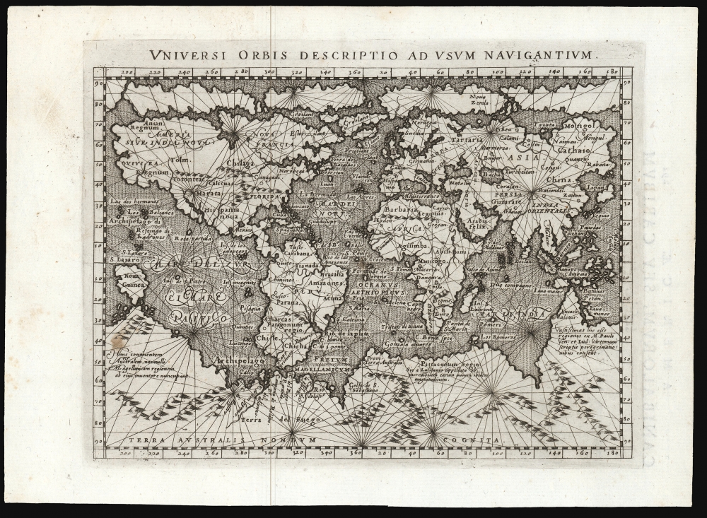
Universi Orbis Descriptio Ad Usum Navigantium.
1596 (undated) 5.25 x 6.75 in (13.335 x 17.145 cm) 1 : 75000000
1596 (undated) 5.25 x 6.75 in (13.335 x 17.145 cm) 1 : 75000000
Description
This beautifully engraved world map is the 1596 first edition of Giovanni Magini's reduction of Mercator's 1569 world wall map. It is among the first commercial maps not by Mercator himself to employ the projection.
A Closer Look
While the small scale necessarily limited detail, it presented Mercator's map well despite its distortion of South America. Although many maps after 1569 reflected Mercator's geography, it was not until after 1596 that maps were produced using Mercator's namesake projection: this among them. Also retained from its illustrious source, Magini's little map is attractively embellished with rhumb lines. While not useful for navigation on such a small map, they communicate the idea of 'navigability' to the reader, reflecting a world where circumnavigations had already occurred.North America
Magini's depiction of the continent - still mostly unexplored by Europeans - is largely speculative. The eastern seaboard juts eastward - a product of inaccurate measurements of longitudes and magnetic variation. No rivers appear on the Gulf Coast. The St. Lawrence is recognizable, and a river emptying into the Gulf of California corresponds roughly to the Colorado. Mexico City is noted. The mythical kingdom of Norumbega is identified along the Atlantic coast. The Pacific Northwest is almost entirely speculative, with the apocryphal kingdoms of Anian (derived from Marco Polo), Quivira (a kingdom of gold associated with Coronado's expedition), and Tolm (derived from Polo) present. The curious inclusion of Polo's references in maps of North America underscores the reality that, even in the late 16th century, European cartographers remained uncertain regarding the relationship between Asia and North America.South America
South America shows the greatest divergence from Mercator's model. Although Mercator's bulge on the western coast is evident, the whole of South America is compressed on the east-west axis. At the very tip of South America, the Strait of Magellan gives way not to Tierra del Fuego but to the sprawling apocryphal continent of Terra Australis. Further north, the Rio de la Plata and, of course, the Amazon River can be discerned. Several known centers are mapped, including Quito and Cusco.Terre Australis
The southern Polar Regions are dominated by the vast apocryphal continent of Terra Australis. Terra Australis was a long-speculated landmass supposedly situated in the southern hemisphere. The theoretical basis for the continent dates to the writings of Aristotle, who taught that the globe must be in balance - so as the Americas counterbalanced Europe and Africa, another undiscovered continent must counterbalance Asia.Australia and the Pacific
While the map pre-dates the official discovery of Australia in 1606 by Dutchman Willem Janszoon, a large promontory extending northwards from Terra Australis is highly suggestive of the western coast of the southern continent. The lands of Maletur and Lucach (from Polo) are noted along the coast. Mercator may have had access to information about Australia from the Dieppe school maps, believed to have been derived from secret, now lost, Portuguese maps. A small island just west of the Proto-Australian promontory is identified as Java Minor, again sourced from the cosmographic speculations of Marco Polo.Asia
Most of the interior reveals ignorance: the Caspian Sea is oriented to the east-west, a typical error of the period. Japan is mapped along a 'kite-shaped' model, with a string of small islands in the southwest leading to one major Japanese island clearly identified. There is no sign of Korea. Of the Great Wall, there is no mention. The Spice Islands appear in embryonic form. Sumatra is recognizable, but Java takes on a bulbous form. Borneo has been elongated, and the whole has been absorbed into the Philippine Islands.Africa
The continent of Africa presents the imaginary interior typical of the period. Two major river systems, the Nile and the Niger, dominate the continent. The Nile follows the Ptolemaic model, extending well into southern Africa.The Long Arm of Zeno
The North Atlantic displays the debt owed by Mercator to the fraudulent geography of Nicolo Zeno the Younger, whose 1558 mapping of the north parts of the world would be absorbed eagerly by Mercator, to be broadly disseminated well into the 17th century. The depiction of Greenland and Iceland here is consistent with Zeno, as is the appearance of the phantom island 'Friesland.' In North America, the Labrador coast bears Zeno's placename 'Estotiland.'Publication History and Census
This map was prepared for inclusion in the 1596 Magini edition of Ptolemy's 'Geography'. The engraving is attributed to Girolamo Porro. The grid-like stippling of the ocean is typical of the maps engraved for this edition. Perhaps 17 examples of various editions of the map are listed in OCLC. Three are cataloged as 1596.CartographerS
Giovanni Antonio Magini (June 13, 1555 - February 11, 1617) was an Italian astronomer, astrologer, cartographer, and mathematician. Born in Padua, he completed his studies in philosophy in Bologna in 1579. In 1588 he was chosen over Galileo Galilei as the chair of mathematics at the University of Bologna after the death of Egnatio Danti. Magini was a prolific writer, putting forth theories of celestial motion (he was a supporter of a geocentric solar system), the use of quadrants in surveying and astronomy, and trigonometry. In 1608, Magini produced the first map of Italy to improve on that of Gastaldi: his meticulously researched and beautifully engraved 8-sheet Italia Nuova was hugely influential: upon its publication, Blaeu promptly copied it to produce his own wall map of Italy; the rest of the mapmaking establishment swiftly followed suit. Consequently, virtually every 17th century map of Italy can be identified as a derivative of Magini's monumental achievement. His atlas, Atlante geografico d’Italia, was published posthumously by his son in 1620. This work was intended to include maps of every Italian region with exact nomenclature and historical notes. He also served as court astrologer for the Duke of Mantua. More by this mapmaker...
Girolamo Porro (1520 - 1604) was an Venetian engraver, humanist, illustrator, map maker, and publisher. Porro was born in Padua but lived most of his life in Venice. Porro worked with a number of important Venetian humanists including Camillo Camilli, Scipione Barbuo, Porcacchi, Ruscelli, and Ariosto. Cartographically Porro has produced only a few works, but these include such important works as the maps for Porcacchi's 1572 Isole piu Famose del Mondo (including the first obtainable specific map of North America), and the maps included with Ruscelli's 1574 Italian translation of Ptolemy's Geographia. Learn More...
Gerard Mercator (March 5, 1512 - December 2, 1594) is a seminal figure in the history of cartography. Mercator was born near Antwerp as Gerard de Cremere in Rupelmonde. He studied Latin, mathematics, and religion in Rupelmonde before his Uncle, Gisbert, a priest, arranged for him to be sent to Hertogenbosch to study under the Brothers of the Common Life. There he was taught by the celebrated Dutch humanist Georgius Macropedius (Joris van Lanckvelt; April 1487 - July 1558). It was there that he changed him name, adapting the Latin term for 'Merchant', that is 'Mercator'. He went on to study at the University of Louvain. After some time, he left Louvain to travel extensively, but returned in 1534 to study mathematics under Gemma Frisius (1508 - 1555). He produced his first world map in 1538 - notable as being the first to represent North America stretching from the Arctic to the southern polar regions. This impressive work earned him the patronage of the Emperor Charles V, for whom along with Van der Heyden and Gemma Frisius, he constructed a terrestrial globe. He then produced an important 1541 globe - the first to offer rhumb lines. Despite growing fame and imperial patronage, Mercator was accused of heresy and in 1552. His accusations were partially due to his Protestant faith, and partly due to his travels, which aroused suspicion. After being released from prison with the support of the University of Louvain, he resumed his cartographic work. It was during this period that he became a close fried to English polymath John Dee (1527 - 1609), who arrived in Louvain in 1548, and with whom Mercator maintained a lifelong correspondence. In 1552, Mercator set himself up as a cartographer in Duisburg and began work on his revised edition of Ptolemy's Geographia. He also taught mathematics in Duisburg from 1559 to 1562. In 1564, he became the Court Cosmographer to Duke Wilhelm of Cleve. During this period, he began to perfect the novel projection for which he is best remembered. The 'Mercator Projection' was first used in 1569 for a massive world map on 18 sheets. On May 5, 1590 Mercator had a stroke which left him paralyzed on his left side. He slowly recovered but suffered frustration at his inability to continue making maps. By 1592, he recovered enough that he was able to work again but by that time he was losing his vision. He had a second stroke near the end of 1593, after which he briefly lost speech. He recovered some power of speech before a third stroke marked his end. Following Mercator's death his descendants, particularly his youngest son Rumold (1541 - December 31, 1599) completed many of his maps and in 1595, published his Atlas. Nonetheless, lacking their father's drive and genius, the firm but languished under heavy competition from Abraham Ortelius. It was not until Mercator's plates were purchased and republished (Mercator / Hondius) by Henricus Hondius II (1597 - 1651) and Jan Jansson (1588 - 1664) that his position as the preeminent cartographer of the age was re-established. Learn More...
Source
Magini, G., Geographiae universae tum veteris tum novae absolutissimum opus voluminibus distinctum, (Venice: Karera) 1596.
Condition
Fine. A bright, unblemished example with full margins and a bold strike.
References
OCLC 165574972.