This item has been sold, but you can get on the Waitlist to be notified if another example becomes available, or purchase a digital scan.
1779 Pallas and Mentelle Map of the Physical World
World-mentelle-1779$225.00

Title
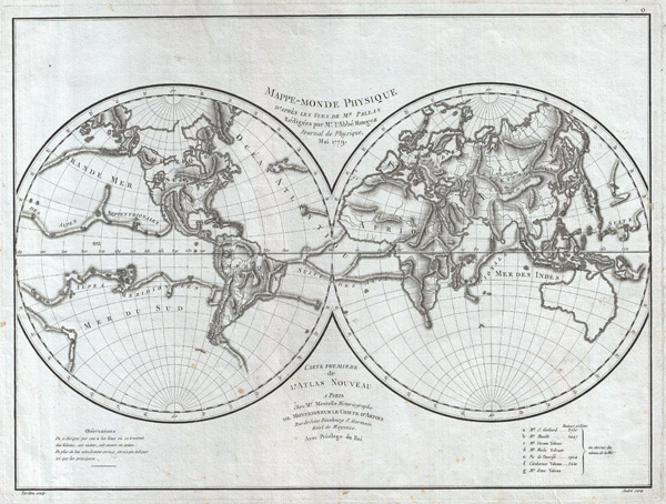
Mappe-Monde Physique d'Apres les Vues de Mr. Pallas Redigees par Mr. l'Abbe Mongez Journal de Physique, Mai, 1779.
1779 (dated) 13 x 17 in (33.02 x 43.18 cm)
1779 (dated) 13 x 17 in (33.02 x 43.18 cm)
Description
This is a highly unusual 1779 map of the world exhibiting a very peculiar physical topography that reveals mountain ranges both on land and under the sea. The curious undersea mountain ranges displayed here was drawn by Abbe Mongez to illustrate the geographical theories of Peter Simon Pallas, a German polymath living in Russia, who speculated that mountain ranges originated from a series of interterrestial explosions (volcanoes), many of which are noted on the map as asterisks.
Aside from Pallas's unusual marine topography, this map follows many of the speculative cartographic conventions of the late 18th century. These include the presence of a large inland sea in the western part of North America, a series of navigable channels in modern day Canada (harkening to the mythical Admiral De Fonte's journals), and a mountainous Nile source in Africa. Van Diemen's Land or Tasmania is attached to the mainland of Australia. A southern continent is only tenuously suggested by two speculative landmasses shown in the southern Indian Ocean and just south of Tierra del Fuego.
This map was first drawn by Abbe Mongez, then engraved by Ambrose Tardieu for inclusion as title plate, number 0, or folio 1 in Mentelle's 1779 Atlas Universel
A curious side note. The Abbe Mongez, who drew this map, was the geologist and naturalist on La Perouse's ill-fated expedition to the Pacific. The Perouse expedition shipwrecked in 1788 on the island of Vanikoro and, after living on the island for a short time, vanished entirely. Recently the remains of the Perouse wreckage, including a mysterious skull, were discovered on the Vanikoro reefs. Forensic scientists have reconstructed the facial features of the skull which many believe to be none other than the Abbe Mongez.
CartographerS
Edme Mentelle (October 11, 1730 - April 28, 1816) was a French geographer and historian active in Paris during the late 18th century. Mentelle was born in Paris in 1730. He studied under the historian Jean-Baptiste Louis Crevier at the College of Beauvais before accepting a position as professor of Geology and History at the Ecole Militaire where, incidentally, he tutoring the young Napoleon Bonaparte. He remained in this position until the institution was abolished in 1792. Mentelle later worked as a private tutor and then as a professor of Geography at the Ecole Normale. From 1795 he was a member of the Institut National des Sciences et des Arts, which he helped to found. Mentelle published a number of importantly geographical works including the 1778 Geographie Comparee, the 1779 Atlas Universel, and the 1801 Cours Complet de Cosmographie, de Chronologie, de Geographie et d'Histoire. He is known to have worked with Conrad Malte-Brun, Ambrose Tardieu, Peter Simon Pallas, and other important cartographic figures of his period. Edme Mentelle is frequently erroneously confused with Francois Simon Mentelle, another French Geographer who worked with Cassini on his historic survey of France. More by this mapmaker...
Ambroise Tardieu (March 2, 1788 - January 17, 1841) was a prominent French cartographer and engraver operating in the late 18th and early 19th centuries. He was member of the large and prolific Tardieu family, which, for over 200 years, produced multiple skilled and active engravers. Tardieu's work is known for its beauty and accuracy as well as for its depth of detail. Tardieu's most important work is his version of John Arrowsmith's large format map of the United States, published in 1806. Ambroise Tardieu is eclipsed in fame by his son, artist and medical scholar, August Ambroise Tardieu. Ambroise Tardieu is also frequently confused with Jean Baptiste Pierre Tardieu, another unrelated French map and print engraver active in the early 19th century. Learn More...
Source
Mentelle, E., Atlas Universel, (Paris) 1779.
Condition
Very good. Blank on verso. Original plate mark visible.
References
National Library of Australia, MAP RM 2051.