This item has been sold, but you can get on the Waitlist to be notified if another example becomes available, or purchase a digital scan.
1646 Merian Map of the World
World-merian-1646-2$750.00

Title
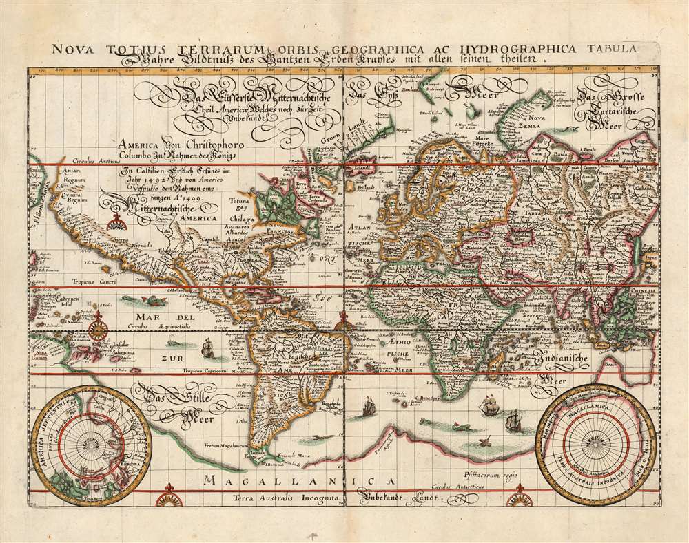
Nova Totius Terrarum Orbis Geographica Ac Hydrographica Tabula...
1646 (undated) 10.25 x 14 in (26.035 x 35.56 cm)
1646 (undated) 10.25 x 14 in (26.035 x 35.56 cm)
Description
This is a scarce 1646 map of the world on the Mercator Projection, produced for inclusion in the 1646 edition of Matthias Merian's Neuwe Archontologia cosmica. It is a meticulous and beautiful reduced version of Blaeu's similarly-titled 1606 map, which remained the dominant depiction of the world using that projection - appearing in all of Blaeu's successful atlas editions up through the 1640s. While this map does not retain the decorative borders of its source, the cartographic detail is reproduced faithfully, including the polar projections in the lower corners.
Cartographic Anomalies of the Age
The map exhibits the apocryphal southern continent of Terra Australis, presumed to exist based upon ancient Aristotelian philosophical speculation regarding geographical balances. It illustrates Korea as an Island. The strait of Anian is identified between Asia and America. In Africa, the map follows Ptolemaic speculation regarding the sources of the Nile, mapping two speculative lakes in southern Africa. Both Lake Parima (Manoa) and Laguna de Xarayes (Lacus Eupana), fictional locations of El Dorado, appear in South America. In North America, the cartographer maps the supposed Seven Cities of Gold, noted here as 'Septem Citao' - a legend dating to the saga of Álvar Núñez Cabeza de Vaca, the discoveries of the conquistador or Francisco Vázquez de Coronado, and ancient Portuguese legends relating to the Moorish invasion of Iberia.Real Discoveries
Despite a plethora of geographical confusions, the map genuinely attempts to embrace the most up to date cartographic information. The Straits of La Maire, discovered by Jacob Le Maire and Willem Schouten in 1616, appear just to the east of Tierra del Fuego - which is now correctly an island. The discoveries of Martin Frobisher and John Davis's expeditions in search of the Northwest Passage in 1576 - 1587 appear in the Canadian Arctic. There is as yet no trace of the Great Lakes or Hudson Bay. The seas around Nova Zembla, in the Russian Arctic, are mapped according to the discoveries of Willem Barentz made between 1594 and 1597. A large promontory south of Java identified as 'Beach' bears a striking resemblance to northern Australia's Arnhem Land and the Gulf of Carpentaria, despite the fact that Australia had not yet been discovered. 'Beach' itself is a reference from Marco Polo's narratives.Publication History and Census
This map was executed in 1646 for inclusion in Matthias Merian's Neuwe Archontologia cosmica, a German translation of Pierre d'Avity's 1616 Les Estats, empires, et principautez du monde. The first, 1638 edition of Merian's work contained a very similar map, but for unknown reasons a new plate was required for later editions. The new plate was a close copy of the first, with minor typographical changes in the lettering, and lacking only Merian's imprint. This may indicate that this later plate was engraved by a different hand. We identify about ten examples of later editions of Merian's Neuwe Archontologia cosmica in institutional collections, and six examples of this separate map.CartographerS
Matthäus Merian (September 22, 1593 - June 19, 1650), sometimes referred to as 'the Elder' to distinguish from his son, was an important Swiss engraver and cartographer active in the early to mid 17th century. Merian was born in Basel and studied engraving in the centers of Zurich, Strasbourg, Nancy and Paris. In time Merian was drawn to the publishing mecca of Frankfurt, where he met Johann Theodor de Bry, son of the famed publisher Theodor de Bry (1528 - 1598) . Merian and De Bry produced a number of important joint works and, in 1617, Merian married De Bry's daughter Maria Magdalena. In 1623 De Bry died and Merian inherited the family firm. Merian continued to publish under the De Bry's name until 1626. Around this time, Merian became a citizen of Frankfurt as such could legally work as an independent publisher. The De Bry name is therefore dropped from all of Merian's subsequent work. Of this corpus, which is substantial, Merian is best known for his finely engraved and highly detailed town plans and city views. Merian is considered one of the grand masters of the city view and a pioneer of the axonometric projection. Merian died in 1650 following several years of illness. He was succeeded in the publishing business by his two sons, Matthäus (1621 - 1687) and Caspar (1627 - 1686), who published his great works, the Topographia and Theatrum Europeaum, under the designation Merian Erben (Merian Heirs). Merian's daughter, Anna Maria Sibylla Merian, became an important naturalist and illustrator. Today the German Travel Magazine Merian is named after the famous engraver. More by this mapmaker...
Willem Janszoon Blaeu (1571 - October 18, 1638), also known as Guillaume Blaeu and Guiljelmus Janssonius Caesius, was a Dutch cartographer, globemaker, and astronomer active in Amsterdam during the late 16th and early 17th centuries. Blaeu was born 'Willem Janszoon' in Alkmaar, North Holland to a prosperous herring packing and trading family of Dutch Reformist faith. As a young man, he was sent to Amsterdam to apprentice in the family business, but he found the herring trade dull and instead worked for his cousin 'Hooft' as a carpenter and clerk. In 1595, he traveled to the small Swedish island of Hven to study astronomy under the Danish Enlightenment polymath Tycho Brahe. For six months he studied astronomy, cartography, instrument making, globe making, and geodesy. He returned to Alkmaar in 1596 to marry and for the birth of his first son, Johannes (Joan) Blaeu (1596 – 1673). Shortly thereafter, in 1598 or 1599, he relocated his family to Amsterdam where he founded the a firm as globe and instrument makers. Many of his earliest imprints, from roughly form 1599 - 1633, bear the imprint 'Guiljelmus Janssonius Caesius' or simply 'G: Jansonius'. In 1613, Johannes Janssonius, also a mapmaker, married Elizabeth Hondius, the daughter of Willem's primary competitor Jodocus Hondius the Elder, and moved to the same neighborhood. This led to considerable confusion and may have spurred Willam Janszoon to adopt the 'Blaeu' patronym. All maps after 1633 bear the Guiljelmus Blaeu imprint. Around this time, he also began issuing separate issue nautical charts and wall maps – which as we see from Vermeer's paintings were popular with Dutch merchants as decorative items – and invented the Dutch Printing Press. As a non-Calvinist Blaeu was a persona non grata to the ruling elite and so he partnered with Hessel Gerritsz to develop his business. In 1619, Blaeu arranged for Gerritsz to be appointed official cartographer to the VOC, an extremely lucrative position that that, in the slightly more liberal environment of the 1630s, he managed to see passed to his eldest son, Johannes. In 1633, he was also appointed official cartographer of the Dutch Republic. Blaeu's most significant work is his 1635 publication of the Theatrum orbis terrarum, sive, Atlas Novus, one of the greatest atlases of all time. He died three years later, in 1638, passing the Blaeu firm on to his two sons, Cornelius (1616 - 1648) and Johannes Blaeu (September 23, 1596 - December 21, 1673). Under his sons, the firm continued to prosper until the 1672 Great Fire of Amsterdam destroyed their offices and most of their printing plates. Willem's most enduring legacy was most likely the VOC contract, which ultimately passed to Johannes' son, Johannes II, who held the position until 1617. As a hobbyist astronomer, Blaeu discovered the star now known as P. Cygni. Learn More...
Gerard Mercator (March 5, 1512 - December 2, 1594) is a seminal figure in the history of cartography. Mercator was born near Antwerp as Gerard de Cremere in Rupelmonde. He studied Latin, mathematics, and religion in Rupelmonde before his Uncle, Gisbert, a priest, arranged for him to be sent to Hertogenbosch to study under the Brothers of the Common Life. There he was taught by the celebrated Dutch humanist Georgius Macropedius (Joris van Lanckvelt; April 1487 - July 1558). It was there that he changed him name, adapting the Latin term for 'Merchant', that is 'Mercator'. He went on to study at the University of Louvain. After some time, he left Louvain to travel extensively, but returned in 1534 to study mathematics under Gemma Frisius (1508 - 1555). He produced his first world map in 1538 - notable as being the first to represent North America stretching from the Arctic to the southern polar regions. This impressive work earned him the patronage of the Emperor Charles V, for whom along with Van der Heyden and Gemma Frisius, he constructed a terrestrial globe. He then produced an important 1541 globe - the first to offer rhumb lines. Despite growing fame and imperial patronage, Mercator was accused of heresy and in 1552. His accusations were partially due to his Protestant faith, and partly due to his travels, which aroused suspicion. After being released from prison with the support of the University of Louvain, he resumed his cartographic work. It was during this period that he became a close fried to English polymath John Dee (1527 - 1609), who arrived in Louvain in 1548, and with whom Mercator maintained a lifelong correspondence. In 1552, Mercator set himself up as a cartographer in Duisburg and began work on his revised edition of Ptolemy's Geographia. He also taught mathematics in Duisburg from 1559 to 1562. In 1564, he became the Court Cosmographer to Duke Wilhelm of Cleve. During this period, he began to perfect the novel projection for which he is best remembered. The 'Mercator Projection' was first used in 1569 for a massive world map on 18 sheets. On May 5, 1590 Mercator had a stroke which left him paralyzed on his left side. He slowly recovered but suffered frustration at his inability to continue making maps. By 1592, he recovered enough that he was able to work again but by that time he was losing his vision. He had a second stroke near the end of 1593, after which he briefly lost speech. He recovered some power of speech before a third stroke marked his end. Following Mercator's death his descendants, particularly his youngest son Rumold (1541 - December 31, 1599) completed many of his maps and in 1595, published his Atlas. Nonetheless, lacking their father's drive and genius, the firm but languished under heavy competition from Abraham Ortelius. It was not until Mercator's plates were purchased and republished (Mercator / Hondius) by Henricus Hondius II (1597 - 1651) and Jan Jansson (1588 - 1664) that his position as the preeminent cartographer of the age was re-established. Learn More...
Source
Merian, M. Neuwe Archontologia cosmica (Franckfurt am Mayn), 1646.
Condition
Very good. Light toning at centerfold, else a very clean example with fine hand color.
References
OCLC 216757362. Shirley, Rodney W., The Mapping of the World: Early Printed World Maps 1472-1700, #369.