This item has been sold, but you can get on the Waitlist to be notified if another example becomes available, or purchase a digital scan.
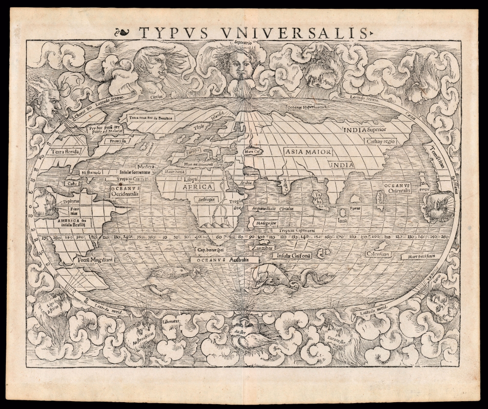
1540 Sebastian Münster map of the world (First block, 1545 third state)
World-munster-1540$5,250.00

Title
Typus Universalis.
1540 (undated) 10.5 x 13.5 in (26.67 x 34.29 cm) 1 : 120000000
1540 (undated) 10.5 x 13.5 in (26.67 x 34.29 cm) 1 : 120000000
Description
This is a superb example of the scarce first block of Sebastian Münster's 1540 map of the world, one of the most distinctive maps of the Age of Discovery. It is a remarkable work of synthesis, providing the best summation of the rapidly expanding known world. Although this first block only appeared in the few editions of Münster's Geographia and Cosmographia that were printed prior to 1550, its content was largely preserved in the second block which replaced it. Thus, it was able to provide a broad audience their first image of the post-Magellanic world, unchallenged until the 1570 publication of Ortelius' Theatrum Orbis Terrarum. The present example is the 1545 third state of the map.
More to the point, this is the first generally accessible world map to show an entirely circumnavigable globe. This map presents a world fully accessible to mariners, via the Straits of Magellan, the optimistically-sized Pacific Ocean, and the unobstructed Indian Ocean. This notion would have been new to Münster's readers, even thirty years after Magellan sailed.
Münster's choice of names is interesting in that he does not use the name Greenland here in any of its variations. Münster instead uses the name Terra nova sive de Bacalhoa (New Land of the Codfish), which he also applied to Greenland on his Scandinavia map. The name would later be seized upon by the Portuguese priest and historian Gaspar Frutuoso, who alleged in his 1570-1580 Saudades de terra that João Vaz Corte-Real (father of Gaspar and Miguel) had discovered this 'New Land of the Codfish' in 1473. No report of this discovery exists prior to Frutuoso's notoriously unreliable account. Lands and Islands of Codfish do appear on earlier maps, any of which Münster is likely to have had access to. He certainly knew Zeigler's 1532 map, which used both 'Gronlandia' and 'Terra Baccalaos' for the same landmass. The 1507 Ruysch map places a small 'Ins. Baccalauras' on the east coast of a larger 'Terra Nova,' which itself is presented as part of the same land mass with 'Gruenlant.'
Although Münster's sources long predated both Frobisher and Davis's exploration of what would later be named Davis Strait, his synthesis of the early mapping of Scandinavia and Greenland with the newer reports of Corte-Real, Verrazano, and Cabot provided a surprisingly clear picture of the opening between North America and Greenland.
An Attractive and Informative Woodcut
As important as its geographical revelations were, the map was also an elegant and attractive woodcut. It is bordered with billowing clouds and superbly executed wind-heads marking the cardinal directions, puffing their breezes over the waters. The southern oceans are prowled by two great sea monsters. One of the distinguishing features of this 1540 block from the 1550 is that the wind-heads of the east and the west are positioned within the border of the map. The revision of the map in 1550 would have these placed outside the map with the rest.An Impressive Array of Firsts
Along with his map of America, Münster's world is the first map to name the Pacific Ocean and the first acquirable one to name the Straits of Magellan. It ranks among the earliest acquirable maps to show and name Japan (Zipangri, here just off the American coast.). In conjunction with Munster's concurrently published map of Asia, this is the first map to show Asia in a form shorn of Ptolemaic elements: there is no 'Dragon's Tail' or other element retained from Ptolemy's land bridge connecting Africa and China, and it is the first generally acquirable world map to hint at the existence of the East Indies. As distinct from the Ptolemaic maps of the late 15th and early 16th century, the island 'Taprobana' is applied not to Sri Lanka, but to Sumatra.More to the point, this is the first generally accessible world map to show an entirely circumnavigable globe. This map presents a world fully accessible to mariners, via the Straits of Magellan, the optimistically-sized Pacific Ocean, and the unobstructed Indian Ocean. This notion would have been new to Münster's readers, even thirty years after Magellan sailed.
Speculative Geography in America
There being vast gaps in European scholars’ knowledge of the Americas, Münster and any other geographers of his era had to fill in with speculation - leading to a wealth of unusual features. The Florida peninsula is recognizable, although the entire region west of Verrazano's Sea is identified as 'Terra Florida.' The Caribbean is represented by the two principal islands of Cuba and Hispaniola. The whole of the northeastern part of North America is labeled 'Francisca,' derived from Giovanni Verrazano's nod to his patron, Francis I, king of France. The wedge-like bay bisecting North America was derived from interpretations of Verrazano’s observations during his 1524 voyage. This so-called 'Sea of Verrazano' would also appear on Münster’s map of America.Gaspar Corte-Real's Newfoundland
Off the coast of Francisca is an island named Corterati. This name comes from Waldseemüller's 1516 Carta Marina, and is a misspelling of the name of Gaspar Corte-Real as found on the Portuguese 1502 Cantino map. That 1502 manuscript represents the sole cartographic evidence of Gaspar Corte-Real's 1501 transatlantic voyage, which may present the first cartographic representation of Newfoundland. The Waldseemüller applies 'Coterati' to an island south and west of a land mass entitled 'Terra Laboratoris.' Despite the failure of the actual documentary record in determining specifically what lands Gaspar Corte-Real actually found before he disappeared, the consensus interpretation of both the Cantino and Waldseemüller is that the land associated with 'Coterati' was Newfoundland. Münster's use of this toponym, both here and on his America map, is a strong indication that he was informed at least in part by the Carta Marina. His unambiguous presentation of 'Coterati' as an island sets it apart among the earliest glimpses of Newfoundland to appear on a map.The North Part of the World
A prominent arctic strait north of America is labeled Per hoc fretū iter paret ad Molucas (Through this strait there is a clear passage to the Moluccas). This was the most explicit claim with respect to a Northwest Passage that had yet appeared on a map - despite no actual exploration having revealed any such thing. On the other hand, Münster's mapping of Scandinavia and the arctic strongly discouraged the notion of a Northeast passage: Scandinavia is given an extension reaching far to the west, appearing to include Greenland - here labeled Terra nova sive de Bacalhoa. Münster's connection of Greenland and Scandinavia was partly informed by Jacob Ziegler's 1532 map of the north part of Europe, but earlier maps still had set a precedent for that connection, notably the 1482 Ulm Ptolemy, whose map of Scandinavia originated from a 1427 Claudius Clavus manuscript.Münster's choice of names is interesting in that he does not use the name Greenland here in any of its variations. Münster instead uses the name Terra nova sive de Bacalhoa (New Land of the Codfish), which he also applied to Greenland on his Scandinavia map. The name would later be seized upon by the Portuguese priest and historian Gaspar Frutuoso, who alleged in his 1570-1580 Saudades de terra that João Vaz Corte-Real (father of Gaspar and Miguel) had discovered this 'New Land of the Codfish' in 1473. No report of this discovery exists prior to Frutuoso's notoriously unreliable account. Lands and Islands of Codfish do appear on earlier maps, any of which Münster is likely to have had access to. He certainly knew Zeigler's 1532 map, which used both 'Gronlandia' and 'Terra Baccalaos' for the same landmass. The 1507 Ruysch map places a small 'Ins. Baccalauras' on the east coast of a larger 'Terra Nova,' which itself is presented as part of the same land mass with 'Gruenlant.'
Although Münster's sources long predated both Frobisher and Davis's exploration of what would later be named Davis Strait, his synthesis of the early mapping of Scandinavia and Greenland with the newer reports of Corte-Real, Verrazano, and Cabot provided a surprisingly clear picture of the opening between North America and Greenland.
Iceland
An island north of the British Isles is here named Thyle, which on his Scandinavia map is used in conjunction with Island to refer to Iceland. The placename Islandia here appears on the promontory connecting Greenland to Scandinavia, but this is likely a compositional error (Münster, after all, names Iceland correctly on the Scandinavia map.) The 1550 map would simplify the toponymy, dispensing with Thyle and associating the name Island more clearly with Iceland.Africa
Likewise, this is one of the earliest acquirable world maps to show the continent of Africa in recognizable form. Madagascar appears in roughly the correct location. Zanzibar appears as an island much farther out from land than is accurate - its resulting visibility perhaps underscoring its rising significance. Africa's interior nonetheless retains the Ptolemaic geography for the course of the Nile, and its sources in the Mountains of the Moon.Publication History and Census
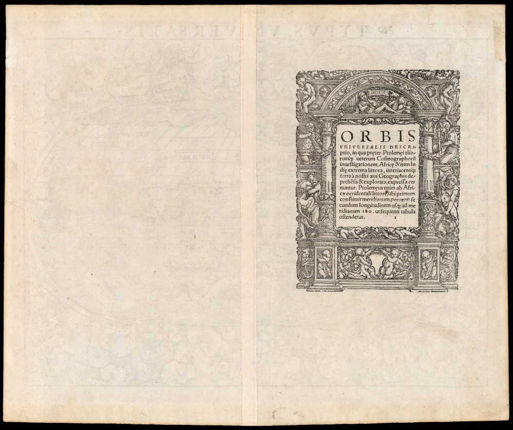
This map first appeared in Münster’s 1540 edition of Ptolemy's Geographia, appearing as well in all but the 1552 editions of that work as well as the German editions of Münster's Cosmographia until 1548. In 1550, the woodblock for the map was re-cut by formschneider David Kandel, introducing a variety of changes. That second block appeared first in the German edition of 1550 and remained in use until 1578. The subsequent editions of Cosmographia employed an entirely new map based on Ortelius. This specific example is a first block, corresponding typographically the 1545 Latin edition of Geographia. This edition of Geographia Universalis is catalogued in thirty-six institutional collections. We see two examples of this edition of the separate map in OCLC, and five examples of the first block overall. The map appears on the market from time to time.Cartographer
Sebastian Münster (January 20, 1488 - May 26, 1552), was a German cartographer, cosmographer, Hebrew scholar and humanist. He was born at Ingelheim near Mainz, the son of Andreas Munster. He completed his studies at the Eberhard-Karls-Universität Tübingen in 1518, after which he was appointed to the University of Basel in 1527. As Professor of Hebrew, he edited the Hebrew Bible, accompanied by a Latin translation. In 1540 he published a Latin edition of Ptolemy's Geographia, which presented the ancient cartographer's 2nd century geographical data supplemented systematically with maps of the modern world. This was followed by what can be considered his principal work, the Cosmographia. First issued in 1544, this was the earliest German description of the modern world. It would become the go-to book for any literate layperson who wished to know about anywhere that was further than a day's journey from home. In preparation for his work on Cosmographia, Münster reached out to humanists around Europe and especially within the Holy Roman Empire, enlisting colleagues to provide him with up-to-date maps and views of their countries and cities, with the result that the book contains a disproportionate number of maps providing the first modern depictions of the areas they depict. Münster, as a religious man, was not producing a travel guide. Just as his work in ancient languages was intended to provide his students with as direct a connection as possible to scriptural revelation, his object in producing Cosmographia was to provide the reader with a description of all of creation: a further means of gaining revelation. The book, unsurprisingly, proved popular and was reissued in numerous editions and languages including Latin, French, Italian, and Czech. The last German edition was published in 1628, long after Münster's death of the plague in 1552. Cosmographia was one of the most successful and popular books of the 16th century, passing through 24 editions between 1544 and 1628. This success was due in part to its fascinating woodcuts (some by Hans Holbein the Younger, Urs Graf, Hans Rudolph Manuel Deutsch, and David Kandel). Münster's work was highly influential in reviving classical geography in 16th century Europe, and providing the intellectual foundations for the production of later compilations of cartographic work, such as Ortelius' Theatrum Orbis Terrarum Münster's output includes a small format 1536 map of Europe; the 1532 Grynaeus map of the world is also attributed to him. His non-geographical output includes Dictionarium trilingue in Latin, Greek, and Hebrew, and his 1537 Hebrew Gospel of Matthew. Most of Munster's work was published by his stepson, Heinrich Petri (Henricus Petrus), and his son Sebastian Henric Petri. More by this mapmaker...
Source
Munster, S., Geographia Universalis, (Basel: Petri) 1545.
Following in the footsteps of Martin Waldseemuller and Lorent Fries before him, Sebastian Munster edited and published a modernized version of Claudius Ptolemy's Geographia. This appeared in six Latin editions in 1540, 1541, 1542, 1545, 1551 and 1552. According to Karrow, Munster based the text on the Latin translation of Willibald Pirkheimer, but he carefully collated it with previous editions, adding notes of his own. The first three editions contained 48 maps, consisting of 27 based on Ptolemy's ancient geography, and 21 maps based on modern geographical knowledge. The latter three editions contained 54 maps, comprised of the same ancient works but with six of the modern maps discarded, and twelve new ones added. For the collector, the modern maps are of sharpest interest. Some were based on Waldseemuller's geography, but many were based on Munster's own surveys and those of other European geographers whose assistance Munster had been able to enlist. Most of these would be reprised in Munster's magnum opus, Cosmographia Universalis. A disproportionate number of Munster's modern maps show contemporary geographical knowledge of the their respective areas for the very first time: The first map to show the continents of the Western Hemisphere; the first map to focus on the continent of Asia; the first modern map to name the Pacific Ocean. Even in cases where earlier maps exist, Munster's works very often remain the earliest such acquirable by the collector.
Condition
Excellent. Some visible specks. Else a fine example with a bold strike and generous margins.
References
OCLC 1145365176. Rumsey 11623.009 (1540 first state). Shirley, Rodney W., The Mapping of the World: Early Printed World Maps 1472-1700, #77.