This item has been sold, but you can get on the Waitlist to be notified if another example becomes available, or purchase a digital scan.
1596 / 1612 Matthias Quad map of the World, after Mercator
World-quad-1596$750.00

Title
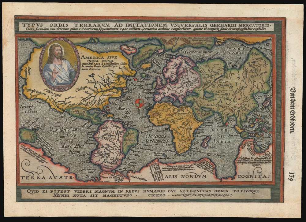
Typus Orbis Terrarum, ad Imitationem Universalis Gerhardi Mercatoris.
1596 (undated) 8.25 x 12.5 in (20.955 x 31.75 cm) 1 : 143000000
1596 (undated) 8.25 x 12.5 in (20.955 x 31.75 cm) 1 : 143000000
Description
This is an attractive example of Matthias Quad's 1596 map of the world, modeled on Mercator's 1569 wall map. Quad's reduction is one of the first maps to use the projection bearing Mercator's name, and of these, it is the one that does so the most precisely. In addition, Quad's map relates to Abraham Ortelius' world map by using at the bottom the Latin quotation from Cicero, similarly decorating Ortelius' work: 'For what can seem important in human affairs to someone who is aware of all eternity and the size of the whole world?' Quad has also added the image of Christ in a medallion in the upper left quadrant of the map, bearing the Latin legend 'Our Lord Jesus Christ the founder, redeemer and future judge of the whole world'.
Mercator's World
Although many maps after 1569 reflected Mercator's geography, it was not until after 1596 that maps were produced using Mercator's namesake projection: this among them.North America
Quad's depiction of the continent - still mostly unexplored by Europeans - is largely speculative. The eastern seaboard juts eastward - a product of inaccurate measurements of longitudes and magnetic variation. Several small rivers appear on the Gulf Coast, but as yet, there was no inkling of the Mississippi. The St. Lawrence is recognizable, and a river emptying into the Gulf of California corresponds roughly to the Colorado. The mythical city of Norumbega is identified along the Atlantic coast. The Pacific Northwest is almost entirely speculative, with the apocryphal kingdoms of Anian (derived from Marco Polo), Quivira (a kingdom of gold associated with Coronado's expedition), and Tolm (derived from Polo) present. Most of the interior of the American Northwest is covered by the portrait of Christ, thus obscuring a region of which mapmakers were entirely ignorant. The curious inclusion of Polo's references in maps of North America underscores the reality that, even in the late 16th century, European cartographers remained uncertain regarding the relationship between Asia and North America.South America
South America shows Mercator's bulge on the western coast and includes a proto-Amazon and a reasonably well-delineated Rio de la Plata. At the very tip of South America, the Strait of Magellan gives way not to Tierra del Fuego but to the sprawling apocryphal continent of Terra Australis.Terre Australis
The southern Polar Regions are dominated by the vast apocryphal continent of Terra Australis. Terra Australis was a long-speculated landmass supposedly situated in the southern hemisphere. The theoretical basis for the continent dates to the writings of Aristotle, who taught that the globe must be in balance - so as the Americas counterbalanced Europe and Africa, another undiscovered continent must counterbalance Asia.Australia and the Pacific
While the map pre-dates the official discovery of Australia in 1606 by Dutchman Willem Janszoon, a large promontory extending northwards from Terra Australis is highly suggestive of the western coast of the southern continent. The lands of Maletur and Lucach (from Polo) are noted along the coast. Mercator may have had access to information about Australia from the Dieppe school maps, believed to have been derived from secret, now lost, Portuguese maps. A small island just west of the Proto-Australian promontory is identified as Java Minor, again sourced from the cosmographic speculations of Marco Polo.Asia
Most of the interior reveals ignorance: the Caspian Sea is oriented to the east-west, a typical error of the period. Japan is mapped along a 'kite-shaped' model, with a string of small islands in the southwest leading to one major Japanese island clearly identified. There is no sign of Korea. Of the Great Wall, there is no mention. The Spice Islands appear in embryonic form. Sumatra is recognizable, but Java takes on a bulbous form. Borneo has been elongated, and the whole has been absorbed into the Philippine Islands.Africa
The continent of Africa presents the imaginary interior typical of the period. Two major river systems, the Nile and the Niger, dominate the continent. The Nile follows the Ptolemaic model, extending well into southern Africa.The Long Arm of Zeno
The North Atlantic displays the debt owed by Mercator to the fraudulent geography of Nicolo Zeno the Younger, whose 1558 mapping of the north parts of the world would be absorbed eagerly by Mercator, to be broadly disseminated well into the 17th century. The depiction of Greenland and Iceland here is consistent with Zeno, as is the appearance of the phantom islands of Frischland and Drogeo. In North America, the Labrador coast bears Zeno's placename 'Estotiland'.Publication History and Census
This map was prepared for inclusion in the 1596 edition of Matthias Quad's Europae, but it would enjoy a long print history in other works. The present example is typographically consistent with examples printed in J. Rauw's 1612 Cosmographia. The map appears on the market from time to time in its various editions.CartographerS
Matthias Quad (1557 - October 29, 1613) was Dutch engraver active in Cologne during the late 16th and early 17th centuries. Quad was born in the Netherlands and studied engraving under Johannes van Deutecum (fl. 1552 - 1606) of Deventer and Hendrick Goltzius (1558-1616) of Haarlem. Around 1580 he relocated to Heidelberg or Cologne where he primarily engraved geographical texts in conjunction with fellow publisher Johann Bussemacher. In 1608 he published an atlas, Fasciculus Geographicus, with Bussemacher in Cologne. In 1609, another major work, his Teutscher Nation Herligkeit, a historico-cultural regional study of Germany, was published by Wilhelm Lutzenkirchen . More by this mapmaker...
Gerard Mercator (March 5, 1512 - December 2, 1594) is a seminal figure in the history of cartography. Mercator was born near Antwerp as Gerard de Cremere in Rupelmonde. He studied Latin, mathematics, and religion in Rupelmonde before his Uncle, Gisbert, a priest, arranged for him to be sent to Hertogenbosch to study under the Brothers of the Common Life. There he was taught by the celebrated Dutch humanist Georgius Macropedius (Joris van Lanckvelt; April 1487 - July 1558). It was there that he changed him name, adapting the Latin term for 'Merchant', that is 'Mercator'. He went on to study at the University of Louvain. After some time, he left Louvain to travel extensively, but returned in 1534 to study mathematics under Gemma Frisius (1508 - 1555). He produced his first world map in 1538 - notable as being the first to represent North America stretching from the Arctic to the southern polar regions. This impressive work earned him the patronage of the Emperor Charles V, for whom along with Van der Heyden and Gemma Frisius, he constructed a terrestrial globe. He then produced an important 1541 globe - the first to offer rhumb lines. Despite growing fame and imperial patronage, Mercator was accused of heresy and in 1552. His accusations were partially due to his Protestant faith, and partly due to his travels, which aroused suspicion. After being released from prison with the support of the University of Louvain, he resumed his cartographic work. It was during this period that he became a close fried to English polymath John Dee (1527 - 1609), who arrived in Louvain in 1548, and with whom Mercator maintained a lifelong correspondence. In 1552, Mercator set himself up as a cartographer in Duisburg and began work on his revised edition of Ptolemy's Geographia. He also taught mathematics in Duisburg from 1559 to 1562. In 1564, he became the Court Cosmographer to Duke Wilhelm of Cleve. During this period, he began to perfect the novel projection for which he is best remembered. The 'Mercator Projection' was first used in 1569 for a massive world map on 18 sheets. On May 5, 1590 Mercator had a stroke which left him paralyzed on his left side. He slowly recovered but suffered frustration at his inability to continue making maps. By 1592, he recovered enough that he was able to work again but by that time he was losing his vision. He had a second stroke near the end of 1593, after which he briefly lost speech. He recovered some power of speech before a third stroke marked his end. Following Mercator's death his descendants, particularly his youngest son Rumold (1541 - December 31, 1599) completed many of his maps and in 1595, published his Atlas. Nonetheless, lacking their father's drive and genius, the firm but languished under heavy competition from Abraham Ortelius. It was not until Mercator's plates were purchased and republished (Mercator / Hondius) by Henricus Hondius II (1597 - 1651) and Jan Jansson (1588 - 1664) that his position as the preeminent cartographer of the age was re-established. Learn More...
Source
Rauw, J., Cosmographia, (Frankfurt) 1612.
Condition
Good. Margins extended on three sides; upper border reinstated in manuscript.
References
OCLC 39451431 (1596). Rumsey 9690.010 (1600). Shirley, Rodney W., The Mapping of the World: Early Printed World Maps 1472-1700, no. 197.