
This item below is out of stock, but another example (left) is available. To view the available item, click "Details."
Details
1561 Ruscelli Double-Hemisphere Map of the World
$2,500.00
1561 Ruscelli Double-Hemisphere Map of the World
World-ruscelli-1561-4$1,375.00

Title
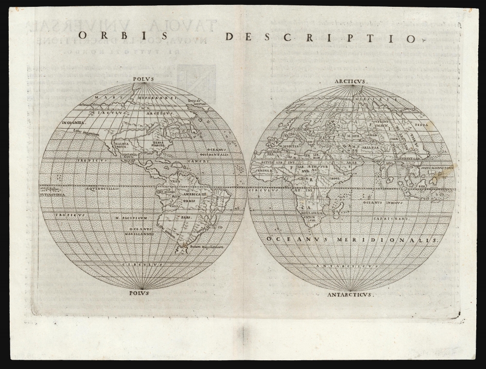
Orbis Descriptio.
1561 (undated) 6.25 x 10 in (15.875 x 25.4 cm) 1 : 160000000
1561 (undated) 6.25 x 10 in (15.875 x 25.4 cm) 1 : 160000000
Description
This is the 1561 Girolamo Ruscelli map of the world, in the first state of the first plate. It is the earliest acquirable double hemisphere world map, and is the first such to appear in a geography. Like most maps in Ruscelli's work, the broad geographic details were derived from Giacomo Gastaldi's (1500 - 1566) 1548 Ptolemy. Here, the double-hemispherical projection - along with elements incorporated from new geographical sources - transforms this map into a fully new composition. Amongst printed maps, the only earlier map using this projection is the unacquirable 1555 Georgio Sideri 'Calapoda' (fl. 1537 - 1565) map.
Although Ruscelli preserves Greenland as separate from the American mainland on his copy of the Zeno map, his conflation of it with Labrador on this world map seems to be an attempt to reconcile the Zeno information with the Gastaldi cartography. Ruscelli's advocacy for the Zeno cartography and its synthesis with Gastaldi's (as here) was probably the spur leading Mercator and Ortelius to embrace the same.
The Arctic lands extend from Greenland and North America over the pole to Europe. In Arctic America, Ruscelli applies both the terms Terra de Lavorad and 'Hyperborei' , a classical geographical term originally applied to northern Eurasia, and later to northern Asia. That name here underscores Ruscelli's argument for a land connection between Asia and North America. A 'Mare Glaciale' covers the rest of the north, corresponding to the Mare Scithio appearing on Gastaldi's 1548 Gastaldi maps.
A Closer Look
The map is oriented to the north, with the three parts of the Old World in the right hemisphere and the Fourth Part of the World - the Americas - dominating the left hemisphere. Some geographical elements are derived from Gastaldi's 1546 and 1548 world maps, but unlike Ruscelli's Carta Marina Nuova Tavola (which was a faithful copy of Gastaldi's 1548 Carta Marina Nova Tabula), this map diverges from any prior source.North Part of the World
Ruscelli's depiction of the Arctic is very distinctive, most likely the result of Ruscelli's embrace of the egregious 1558 Zeno Carta de Navegar: this is the first map of the world to incorporate the Zeno geography. While the map does not include the infamous phantom island Frisland, the elongated island in the North Atlantic conforms very closely to Iceland as it appeared on the 1558 Zeno. If that island is assumed to be Iceland, the southern coast of the great Arctic landmass presented on this map must be Greenland.Although Ruscelli preserves Greenland as separate from the American mainland on his copy of the Zeno map, his conflation of it with Labrador on this world map seems to be an attempt to reconcile the Zeno information with the Gastaldi cartography. Ruscelli's advocacy for the Zeno cartography and its synthesis with Gastaldi's (as here) was probably the spur leading Mercator and Ortelius to embrace the same.
The Arctic lands extend from Greenland and North America over the pole to Europe. In Arctic America, Ruscelli applies both the terms Terra de Lavorad and 'Hyperborei' , a classical geographical term originally applied to northern Eurasia, and later to northern Asia. That name here underscores Ruscelli's argument for a land connection between Asia and North America. A 'Mare Glaciale' covers the rest of the north, corresponding to the Mare Scithio appearing on Gastaldi's 1548 Gastaldi maps.
Western North America
As with Gastaldi's maps up to 1561, Ruscelli's map shows a clear connection between the continents of Asia and North America. The present work features a distinctive river system extending from the Gulf of California into the continent. Ruscelli's map also includes imaginary mountain ranges in North America that do not appear on precursor Gastaldi.Unknown Shores
In several key locations, Ruscelli completes coastlines using a distinct broken line to indicate unexplored or speculative territory. On the southwest coast of South America and on the southern coast of the landmass connecting North America and Asia, this is reinforced with the notations Littus incognitum and Littus ignotum. The same use of broken lines is applied to the southern coasts of Tierra del Fuego and Java, though the notation does not appear. The northernmost island of the East Indies is also shown with a dotted, indeterminate coast.An Island Northeast
Ruscelli may have derived his remarkable insular Northeast from the conflation of the Hudson River with the Saint Lawrence appearing on the 1556 Gastaldi-Ramusio La Nuova Francia. Ruscelli's 1561 version of Gastaldi's 1548 Tierra Nueva was similarly amended to include the river system. These features do not appear on any of Gastaldi's printed world maps. The bay separating the American Northeast from 'Terra Florida' may have been influenced by the idea of the Sea of Verrazano, which appears prominently on Gastaldi's Carta Marina but not his other 1548 world map.South America and Tierra del Fuego
The overall shape of South America, including the shape of the mouth of the Rio de la Plata, is similar to the c. 1561 Gastaldi, but is very different from his earlier works, and very distinctive in its broad and angular shape. An important divergence from Gastaldi's world maps is Ruscelli's treatment of Tierra del Fuego. Unlike Gastaldi, and most of the geographers of the era, Ruscelli does not present the land beyond the Strait of Magellan as part of a massive southern continent - instead leaving the area blank.Africa
The delineation of Africa, including the scattering of islands north of Madagascar, appears to be roughly consistent with Gastaldi's geography, preserving the Ptolemaic sourcing of the Nile, and showing a large Senegal River with many tributaries. Madagascar itself is accurately shaped, though without interior detail. It is named only with initials - S.L., indicating 'San Lorenzo,' an early term for the island.Southeast Asia
South Asia is mostly recognizable. The Indian peninsula, though narrow, resembles modern (as opposed to Ptolemaic) geography. Sri Lanka is marked with a Z, indicating that it is being identified as Zeylon (Ceylon), as opposed to Taprobana, which we see contracted into 'Tapr.' and applied to Sumatra. Borneo also appears and is initialed 'Bor.' The island of Java is shown with an indeterminate coast, and the island north of Borneo (roughly corresponding to the Philippines) shows a similarly tentative northern shore. Interestingly, the map lacks Japan - unless the archipelago with the initials 'IA' is intended to represent it. This would conform with Gastaldi's earlier small maps of the world, which also lack Japan.A Short Lineage
As enumerated above, Ruscelli's map incorporated features from conventional maps of the day but applied them in unique ways. Mapmaking in Europe would swiftly outpace Ruscelli, and cartographic innovation would pass from Rome and Venice to Antwerp and the Netherlands. From there, the works of Mercator and Ortelius would become the standards most widely copied by subsequent mapmakers - so much so that the 1571 map produced by Arias Montanus would appear to have materialized out of thin air, despite being essentially an enlarged copy of this Ruscelli.Publication History and Census
This map was engraved for the 1561 first edition of Ruscelli's La Geografia di Claudio Tolomeo. The maps of this edition were engraved two-to-a-plate, and consequently, the platemark runs off the edge of the sheet at the top. Later editions were engraved on a singular plate. We see six examples of this separate map cataloged in OCLC.CartographerS
Girolamo Ruscelli (1500 - 1566) was an Italian polymath, humanist, editor, and cartographer active in Venice during the early 16th century. Born in Viterbo, Ruscelli lived in Aquileia, Padua, Rome and Naples before relocating to Venice, where he spent much of his life. Cartographically, Ruscelli is best known for his important revision of Ptolemy's Geographia, which was published posthumously in 1574. Ruscelli, basing his work on Gastaldi's 1548 expansion of Ptolemy, added some 37 new "Ptolemaic" maps to his Italian translation of the Geographia. Ruscelli is also listed as the editor to such important works as Boccaccio's Decameron, Petrarch's verse, Ariosto's Orlando Furioso, and various other works. In addition to his well-known cartographic work many scholars associate Ruscelli with Alexius Pedemontanus, author of the popular De' Secreti del R. D. Alessio Piemontese. This well-known work, or "Book of Secrets" was a compilation of scientific and quasi-scientific medical recipes, household advice, and technical commentary on a range of topics that included metallurgy, alchemy, dyeing, perfume making. Ruscelli, as Alexius, founded a "Academy of Secrets," a group of noblemen and humanists dedicated to unearthing "forbidden" scientific knowledge. This was the first known experimental scientific society and was later imitated by a number of other groups throughout Europe, including the Accademia dei Secreti of Naples. More by this mapmaker...
Giacomo Gastaldi (c. 1500 - October, 1566) was an Italian astronomer, cartographer, and engineer active in the second half of the 16th century. Gastaldi (sometimes referred to as Jacopo or Iacobo) began his career as an engineer, serving the Venetian Republic in that capacity until the fourth decade of the sixteenth century. During this time he traveled extensively, building a large library relating to voyages and exploration. From about 1544 he turned his attention to mapmaking, working extensively with Gextantiovanni Battista Ramusio, Nicolo Bascarini, and Giovanbattista Pedrezano, as well as taking private commissions for, among others, Venice's Council of Ten. He is credited with the fresco maps of Asia and Africa still extant in the map room of the Doge's Palace. Gastaldi was also one of the first cartographers to embrace copper plate over woodblock engraving, marking an important development in the history of cartography. His 1548 edition of Ptolemy's Geographia was the first to be printed in a vernacular; it was the first to be printed in copperplate. As with his Swiss/German contemporary Münster, Gastaldi's work contained many maps depicting newly discovered regions for the first time, including the first map to focus on the East Coast of North America, and the first modern map of the Indian Peninsula. His works provided the source for the vast majority of the Venetian and Roman map publishers of the 1560s and 70s, and would continue to provide an outsize influence on the early maps of Ortelius, De Jode, and Mercator. Learn More...
Source
Ruscelli, G., La Geografia di Claudio Tolomeo Alessandrino…, (Venice: Vincenzo Valgrisi) 1561.
Beginning in 1561, Girolamo Ruscelli published this important, expanded edition of Giacomo Gastaldi's 1548 Ptolemy. Its maps, engraved in Venice by Giulio Sanuto, were in the main based directly upon those in Gastaldi's 1548 work. The maps were larger format than Gastaldi's, however, and Sanuto's engraving was far clearer and more legible than those appearing in the 1548 work. There are some important additions that distinguish Ruscell's Ptolemy from Gastaldi's. Ruscelli's work contained a map of the habitable world according to Ptolemy, which the Gastaldi lacked; also, the double-hemisphere map appearing in the Ruscelli was new and did not appear in the Gastaldi. Ruscelli's modern map of England was based on the work of George Lily, rather than the Waldseemüller-derived map appearing in the Gastaldi; the Ruscelli is the earliest generally acquirable map of England based on knowledge from someone who lived there. In a fateful innovation, Ruscelli's work included Septentrionalium partium nova tabula,the first copy of Nicolo Zeno's 1558 fraud Carta da Navegar, which introduced a novel mapping of the north parts of the world, including the phantom islands of Frisland, Icaria, Drogeo and Estotiland. Had Ruscelli not copied the Zeno - which had a narrow, brief publication - this preposterous geography would have probably not taken hold. Its inclusion in Ruscelli's beautiful, authoritative and popular work would lead to the adoption of the Zeno map by Mercator, Ortelius, Plancius and their successors, baffling scholars for centuries. Ruscelli's Ptolemy had a long publication history, cementing the influence of the work. It appeared both in Italian and Latin editions, all printed in Venice, throughout the latter 16th century:
- 1561 La Geographia di Claudio Tolomeo Alessandrino, Italian. Venice, Vincenzo Valgrisi.
- 1562 Geographia Cl. Ptolemaei Alexandrini, Latin. Venice, Vincenzo Valgrisi.
- 1564 La Geographia di Claudio Tolomeo Alessandrino, Italian. Venice, Giordano Ziletti.
- 1564 Geographia Cl. Ptolemaei Alexandrini, Latin. Venice, Giordano Ziletti.
- 1574 La Geographia di Claudio Tolomeo Alessandrino, Italian. Venice, Giordano Ziletti.
- 1598 Geographia di Claudio Tolomeo Alessandrino, Italian. Venice, heirs of Melchoir Sessa.
- 1599 Geographia di Claudio Tolomeo Alessandrino, Italian. Venice, heirs of Melchoir Sessa.
Condition
Excellent. Plate mark visible, running off sheet at top, as with all examples of the 1561 plate. Faint text show through, else fine.
References
Rumsey 11311.063. OCLC 60356866. Shirley, Rodney W., The Mapping of the World: Early Printed World Maps 1472-1700, 110.