This item has been sold, but you can get on the Waitlist to be notified if another example becomes available, or purchase a digital scan.
1676 John Speed Map of the World
World-speed-1676$3,500.00

Title
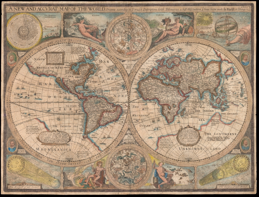
A New and Accurat Map of the World Drawne according to ye truest Descriptions latest Discoveries and best Observations yt have beene made by English or Strangers.
1676 (dated) 15.5 x 20.5 in (39.37 x 52.07 cm) 1 : 110000000
1676 (dated) 15.5 x 20.5 in (39.37 x 52.07 cm) 1 : 110000000
Description
This is John Speed's 1626 map of the world, in its 1676 Bassett and Chiswell edition. It is the earliest acquirable English world map, and the first world map to appear in an English atlas. It is the earliest acquirable world map to illustrate the California-as-an-island myth. It was also singular in its emphasis on the English colonies in America and is the first world map to mark the settlement of New Plymouth. The map presents the globe in a double-hemisphere format, and is embellished with astronomical diagrams and allegorical representations of the seasons, as well as portraits of famous circumnavigators.
As is the case with all of the Speed maps engraved during his lifetime, the engraver was Dutch - in the case of the present work, elements of style suggest Abraham Goos as the artist. Goos's model for the composition of the map was predominantly one of his countrymen's works, the 1617 Nova Totius Terrarum Orbis Geographica ac Hydrographica Tabula of Jodocus Hondius. A cursory look over the Far East, Japan, the Straits of Anian, and the bulk of South America and Africa show the debt owed the earlier Dutch map. The Pacific Northwest also resembles that of the Hondius, in most respects. Like the Hondius map, Speed's includes in South America the legendary El Dorado on the shore of Lake Parime. In the north Atlantic, the fraudulent geography of Nicolo Zeno is made evident by the presence of the phantom island Frisland, east of Labrador.
There are an array of geographical features that are pulled from Grent to improve on Hondius' map, however, and there are improvements here that appear on neither of the precursor maps.
This map differs from these precursors by its curtailment of Magellanica in the Pacific at the Tropic of Capricorn. This is likely due to the inclusion on this map of a handful of Pacific Islands also revealed by Le Maire and Schouten's circumnavigation - 'Cocos Island' (Tafahi), 'Traitors Island' (Niuatoputapu), 'Island of Good Hope' (Niuafo'ou) and the Hoorn Islands (Futuna and Alofi). The presence of these islands counterindicated the existence, in that place, of a Terra Australis incognita.
A Look at the Sources
Speed's map did not appear in a vacuum. In its composition, it owes much to two, unacquirable, precursor maps. One primary model was William Grent's 1625 A New and Accurate Map of the World Drawne According To the truest Descriptions, latest Discoveries, and best Observations, that have been made by English, or Strangers. Grent's map provided Speed his explorer's portraits, the celestial charts, and the astronomical charts. Many of the text notations on the map are also sourced from Grent's work. The geographical features of the map differ in many respects, however.As is the case with all of the Speed maps engraved during his lifetime, the engraver was Dutch - in the case of the present work, elements of style suggest Abraham Goos as the artist. Goos's model for the composition of the map was predominantly one of his countrymen's works, the 1617 Nova Totius Terrarum Orbis Geographica ac Hydrographica Tabula of Jodocus Hondius. A cursory look over the Far East, Japan, the Straits of Anian, and the bulk of South America and Africa show the debt owed the earlier Dutch map. The Pacific Northwest also resembles that of the Hondius, in most respects. Like the Hondius map, Speed's includes in South America the legendary El Dorado on the shore of Lake Parime. In the north Atlantic, the fraudulent geography of Nicolo Zeno is made evident by the presence of the phantom island Frisland, east of Labrador.
There are an array of geographical features that are pulled from Grent to improve on Hondius' map, however, and there are improvements here that appear on neither of the precursor maps.
The Island of California
Speed's map is the first world map sporting an insular California that a collector can hope to find. After the unacquirable 1624 Goos T'Noorder deel van West-Indien, the equally unobtainable Grent world map and the 1625 Briggs North America would be the only earlier glimpses of this geographical myth to appear. Its appearance on the Speed provides a connection to both the Grent map and the Briggs: The 1617 Hondius was produced prior to the spread of the idea that California was an island; Grent's world map was the first to include that innovation. Speed's map does not copy Grent's delineation of that island, however, choosing to follow instead Henry Briggs' 1625 model whilst retaining Hondius' coastline continuing to the north. The presence of the island here would place Speed's map in the geographical state-of-the-art: for the remainder of the century, more maps would show an insular Californa than not.Tierra del Fuego, and Whittling Away Magellanica
Like most early maps of the world, Speed's fills the southern part of the world with a massive 'Magallanica' - the Terra Australis Incognita, or the Southern unknown land. Both the Hondius and the Grent share in this. Hondius' 1617 map showed the massive landmass to begin at the Strait of Magellan: although Le Maire and Schouten had already passed through their own strait and entered the Pacific by passing south of Tierra del Fuego, Schouten would not return to Amsterdam until June 1617 and Hondius probably had not received this news at the time his map was completed. Speed's map instead follows Grent in its depiction of the Strait of Le Maire, and Cape Hoorn, and Staten Island, thus separating Tierra del Fuego from the hypothetical southern continent.This map differs from these precursors by its curtailment of Magellanica in the Pacific at the Tropic of Capricorn. This is likely due to the inclusion on this map of a handful of Pacific Islands also revealed by Le Maire and Schouten's circumnavigation - 'Cocos Island' (Tafahi), 'Traitors Island' (Niuatoputapu), 'Island of Good Hope' (Niuafo'ou) and the Hoorn Islands (Futuna and Alofi). The presence of these islands counterindicated the existence, in that place, of a Terra Australis incognita.
New England
English efforts to colonize North America are memorialized here, largely following the lead of the Grent map in naming New England and Virginia (including The Virginian Sea) and crediting the discovery of those lands to Captain John Smith. While Grent did include a depiction of the Chesapeake, Speed's portrayal of the coast of New England proper is much better defined and is probably drawn from Briggs' map of North America. Long Island is recognizable but unnamed; Cape Cod is shown and named. The colony of New Plymouth is named, a first on a world map.I. Caupaw, derived from the name of the indigenous settlement 'Capaum,' is probably the first reference to the island of Nantucket to appear on a world map. In an ambitious move, the bulk of what was named (on the Hondius) Nova Francia is here named 'New Britaine.'Diagrams and Decorative Elements
It is interesting that, while the most obvious geographical features pertaining to the circumnavigation of the world on this map reflect the voyage of Le Maire and Schouten, the explorers' portraits flanking the map do not include them. The Dutch are represented instead by Oliver van Noort, whose voyage passed through the Strait of Magellan on his 1598 voyage. Magellan himself is also pictured. The other two circumnavigators honored on the map are Sir Francis Drake, and Sir Thomas Cavendish. These decorative elements were copied from Grent's 1625 map, as were the diagrams illustrating an armillary sphere, eclipses of the Sun and of the moon, and the diagram of the geocentric solar system. The two celestial hemispheres at the top and bottom are derived from those appearing on the 1617 Hondius map, as are the four allegorical representations of the elements. In its combination of images, Speed's map introduces to English geography the stylistic elements for which the Dutch were already renowned.Publication History and Census
This map was engraved in 1626, probably by Abraham Goos, whose imprint does not appear here but does appear on a number of the other of Speed's maps. The map appeared in all editions of Speed's A Prospect of the most Famous Parts of the World, appearing in four identified states. The first, dated 1626, appeared with George Humble's imprint in Speed's atlas from 1627 until 1650. The second state, with the date 1651, replaced George's name with that of his son, William. A third state, from 1662 and possibly 1665, bore the imprint of Roger Rea and his son. The present, fourth-state example, though still dated 1651, bears the sellers' imprint of Thomas Bassett and Richard Chiswell and is thus dated 1676. None of these state changes included any alteration of the geographical matter of the map. We see twenty separate examples of the map listed in OCLC. The map appears on the market from time to time.CartographerS
John Speed (1542 - 1629) was an important English historian and cartographer active in the early 17th century. Speed was born in Fardon, Cheshire and apprenticed under his father as a tailor. Though his heart was never in tailoring, Speed dedicated himself to this profession until he was about 50 years old. During all the time, Speed dedicated his spare time to research as amateur historian and mapmaker - even preparing several maps for Queen Elizabeth. In London, Speed's interest in history lead him to join the Society of Antiquaries. Eventually he befriended the wealthy Sir Fulke Greville, who sponsored his researches and eventually freed him from the haberdashery profession. Working with William Camden, Speed eventually published his 1611 Historie of Great Britaine. Though this history itself was amateurish and of minimal importance, Speed's inclusion of numerous maps of British Cities and town was seminal. In many cases these plans were the first maps ever issued of their respective subjects. Later, turning his attention more fully to Geography, Speed published the magnificent atlas Theatre of the Empire of Great Britaine and, just prior to his death, the 1627 A Prospect of the Most Famous Parts of the World. These were the first British world atlases and have a landmark position in the history of cartography. These atlases continued to be published well after Speed's death. More by this mapmaker...
Abraham Goos (1590 - 1643) was a Dutch engraver of maps, sea charts, and globes based in Antwerp and Amsterdam. He was born in Haarlem, the sone of diamond cutter Pieter Goos and Margaret van de Keere. Through is mother he was related to engraver Pieter van den Keere (Petrus Kaerius; 1571 - 1646), the brother-in-law of map publisher Jodocus Hondius (1563 - 1612). He was likely trained in engraving by Kaerius, as his first known work is a collaboration on the 1614 terrestrial globe of Petrus Plancius. He went on to engrave for Joannes Jansson, Jocodus Hondius, and John Speed. One of his most significant works is the Holy Land map of Yaacov ben Avraham Aladdin, considered one of the earliest printed maps in Hebrew. Abraham Goos was succeeded by his son Pieter Goos (1616 - 1675), who was in tern succeeded by his son Henrik Goos. Learn More...
Source
Speed, J., The Theater of the Empire of Great Britian, 1676. Also in, Speed, J., A Prospect of the Most Famous Parts of the World…, (London) 1676.
Condition
Poor, but stabilized and priced accordingly. Surface mends with some small areas of infill. Sized and stiffened for preservation.
References
OCLC 558018492. Rumsey 12058.169. Shirley, R. The Mapping of the World #317.