
Goos, Abraham

Abraham Goos (1590 - 1643) was a Dutch engraver of maps, sea charts, and globes based in Antwerp and Amsterdam. He was born in Haarlem, the sone of diamond cutter Pieter Goos and Margaret van de Keere. Through is mother he was related to engraver Pieter van den Keere (Petrus Kaerius; 1571 - 1646), the brother-in-law of map publisher Jodocus Hondius (1563 - 1612). He was likely trained in engraving by Kaerius, as his first known work is a collaboration on the 1614 terrestrial globe of Petrus Plancius. He went on to engrave for Joannes Jansson, Jocodus Hondius, and John Speed. One of his most significant works is the Holy Land map of Yaacov ben Avraham Aladdin, considered one of the earliest printed maps in Hebrew. Abraham Goos was succeeded by his son Pieter Goos (1616 - 1675), who was in tern succeeded by his son Henrik Goos.
The Most Beautiful 17th Century English Map of Africa, in a. beautiful old color example.
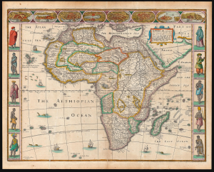
Africae described, the manners of their Habits, and buildings newly done into English by I. S. Are to be sold by Tho Basset in Fleet Street, and Ric Chiswell in St. Pauls Churchyard.
$3,000.00
Acquire
- Digital Map Information
- Suitable for large format printing
- Full resolution TIFF file
- ICC color profile embedded
- Delivered instantly via download link
This is John Speed's 1626 map of Africa, the first English map of the continent, in a beautifully colored 1676 edition. This beautiful map is one of the most desirable early maps of Africa, combining superb engraving, attractive Dutch styling, and entertaining and abundant English text. Moreover, the present example sports old color of unusually high quality. (more details)
Visually Entertaining English Map of Africa.
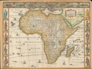
Africae described , the manners of their Habits, and buildings newly done into English by I. S. Are to be sold by Tho Basset in Fleet Street, and Ric Chiswell in St. Pauls Churchyard.
$2,500.00
Acquire
- Digital Map Information
- Suitable for large format printing
- Full resolution TIFF file
- ICC color profile embedded
- Delivered instantly via download link
This is John Speed's 1626 map of Africa. It is the first English map of the continent. This beautiful map is one of the most desirable early maps of Africa, combining superb engraving, attractive Dutch styling, and entertaining and abundant English text. Speed was an accomplished historian and compiler, drawing his maps from state-of-the-art sources. His atlases of the British Isles and the World are among the signal cartographic works of the 17th century. The cartography for this map is drawn from the maps of Jodocus Hondius (whose student Goos actually engraved the map). Hondius' source was ultimately Willem Blaeu's 1608 wall map of Africa. As is the case with all of these maps, the map demonstrates 17th century European geography's detailed knowledge of Africa's coasts wedded to a deep mystification of the interior. The course of the Nile, for example, is shown in substantially the same configuration as was supposed in the second century by Claudius Ptolemy. Speed adds descriptive text - for example, noting areas in western and central Africa where gold is said to be found, and indicating areas said to be occupied by Amazons. (more details)
'For an earnest collector of old maps of Persia, this could be the first map.' ~ Alai
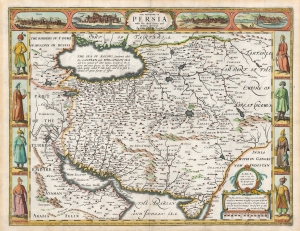
The Kingdome of Persia with the cheef Citties and Habites described. By John Speede.
$2,200.00
Acquire
- Digital Map Information
- Suitable for large format printing
- Full resolution TIFF file
- ICC color profile embedded
- Delivered instantly via download link
This is John Speed's map of Persia in its 1676 Bassett and Chiswell edition. This beautiful map is one of the most desirable early maps of the Near East, combining superb engraving, attractive Dutch styling, and entertaining and abundant English text. While Speed cannot be accused of innovation as a mapmaker, he was an accomplished historian and compiler. His atlases of the British Isles and the World are among the signal cartographic works of the 17th century. (more details)