This item has been sold, but you can get on the Waitlist to be notified if another example becomes available, or purchase a digital scan.
1862 Schnell and Takeda Japanese Map of the World
World2-kangoschnell-1862$2,000.00

Title
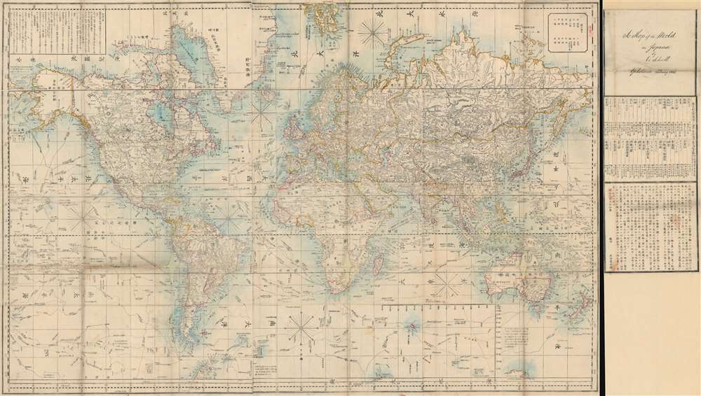
Bankoku Kōkai-zu / 萬国航海圖 / World Navigational Map.
1862 (dated) 36 x 67 in (91.44 x 170.18 cm) 1 : 29500000
1862 (dated) 36 x 67 in (91.44 x 170.18 cm) 1 : 29500000
Description
An important 1862 Bunkyu 2 world map, the product of a clash of Japanese and European cultures and the end of Tokugawa isolationism that lead to the lifelong imprisonment of one of its makers. Centered on Europe, this enormous map covers the entire world on a Mercator Projection, marking it as one of the first Japanese maps to use this western projection model. The map illustrates trade routes from Japan to England, passing through the Malacca Straits and the Red Sea. Major exploratory routes followed by Cook and others, drawn from the Purdy map, are also included. The map is accompanied by its usual side panel with Schnell's manuscript 'Yokohama February 1862' imprint.
Clash of Cultures
This is based upon an 1845 English map of the world by John Purdy. Purdy's map was brought to Japan by the Russian Admiral Yevfimy Putyatin sailing the Diana during a diplomatic mission to negotiate and sign the 1855 Treaty of Shimoda, the first treaty between the Russian Empire and the Empire of Japan. When the Ansei-Tōkai Earthquake struck Japan in 1855, the Diana shipwrecked in Hiroshima Bay. The map was salvaged from the wreckage and came into the hands of Kango Takeda, then working as a translator. Takeda translated the map into Japanese and issued a first edition in Ansei 5 or 1858.The Schnell Edition
Takeda had considerable difficulty with the translation and so when the Dutch merchant, Edwards Schnell arrived in Yokohama in 1860, the two worked together to revise the translation and republish the map, with Schnell's imprint. In this way, the most up to date cartographic knowledge made its way into Japan, although not without cost. By this time Japan had been opened to western trade and the power of the isolationist Tokugawa Shogunate had diminished. Nonetheless, learning of the map, the Shogunate interrogated Takeda family and Kango Takeda himself was imprisoned for the remainder of his days. Schnell saw no repercussions.Publication History and Census
This map was first published in 1858, Ansei 5, by Kango Takeda. It was subsequently revised and published in Yokohama by Edward Schenll, presumable with Kango Takeda as a partner. The map was typically issued with a variety of side panels, some with distance data and the Schnell manuscript imprint, probably in his own hand. Other examples also feature flag charges. This map is scarce on the market with only 3 examples listed in the OCLC.CartographerS
Kango Takeda (武田 簡吾, 18?? - 18??) was a Japanese translator and map publisher active in Numazu (沼津市), Japan, during the late Edo Period. He published one important map in two editions, first in 1858, then in a revised 1862 edition. This second edition was revised and updated with the help of the Dutch merchant Edward Schnell. The work created a stir in isolationist Edo Japan, with Kango Takeda and his entire family interrogated by the Shogunate. Kango himself imprisoned for the remainder of his life. More by this mapmaker...
Edward Schnell (c. 1834 - c. 1890) was a Dutch/German arms dealer active in Japan during the middle part of the 19th century/. He traveled there with his brother Henry Schnell following the enforced opening of Yokohama to foreign trade. Edward, who in the 1850s had served in the Prussian Army and spoke Malay, must have arrived in Japan around 1860 and took a Japanese wife. Kawai Tsugonusuke, with whom he had a boy and purchased property, 'Lot No. 44,' in Yokohama. He teamed up with the Swiss watch dealer Perregeux presumably until 1867. Edward and Henry Schnell also served the Aizu domain as military advisors and procurer of weaponry. Edward was granted the Japanese name Hiramatsu Buhei, which inverted the characters of the daimyo's name Matsudaira. Hiramatsu (Schnell) was given the right to wear swords, as well as a residence in the castle town of Wakamatsu, a Japanese wife (the daughter of a Shonai-han retainer), and retainers. In many contemporary references, he is portrayed as wearing a Japanese kimono, overcoat, and swords, with Western riding trousers and boots. Learn More...
Condition
Good. Right panel detached, as issued. Map exhibits some fill repairs at 3 fold intersections, bottom fold line, and here and there along the border. Backed on Japanese tissue.
References
OCLC 5569126. Univ. of California Library, Berkeley, East Asian Library, A14.