This item has been sold, but you can get on the Waitlist to be notified if another example becomes available, or purchase a digital scan.
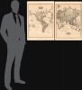
1812 Pinkerton Mercator Projection Map of the World in 2 Sheets
World2Sheets-pinkerton-1812$600.00


Title
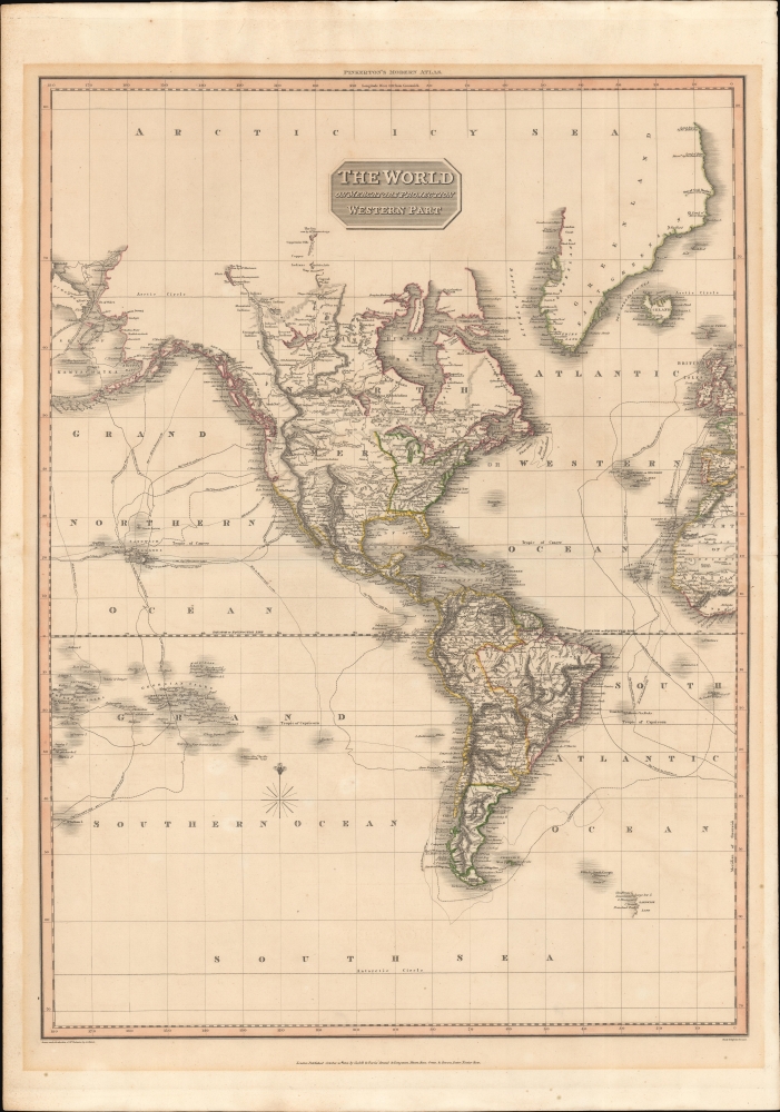
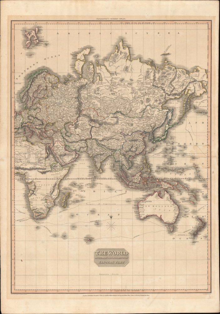
The World on Mercator's Projection Western Part. / The World on Mercator's Projection Eastern Part.
1812 (dated) 31.5 x 44.5 in (80.01 x 113.03 cm) 1 : 40000000
1812 (dated) 31.5 x 44.5 in (80.01 x 113.03 cm) 1 : 40000000
Description
This is John Pinkerton's 1812 map of the world on Mercator's projection, here in two folio sheets.
In South America there is little evidence of the wars of independence then raging throughout the continent - instead presenting Spanish and Brazilian territories as cohesive blocks. Nonetheless, Simón Bolívar, in a series of ongoing wars, was attempting to liberate and consolidate modern-day Venezuela, Colombia, Ecuador, Peru, and Bolivia, but was suffering nonstop setbacks, including the 1812 fall of the First Republic of Venezuela. In Argentina, the 1810 May Revolution liberated Buenos Aires, and in 1812, the revolutionaries were organizing military campaigns to spread independence to other parts of the Viceroyalty of the Río de la Plata. Similarly, Chile began its own struggles for independence in 1810, but by 1812, infighting among revolutionary factions stymied progress. Brazil, on the other hand, remained solidly a colony of Portugal, with the royal family, fleeing Napoleon, relocating there in 1808, making Brazil, in essence, the center of an empire in exile.
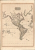
Western Sheet
The western sheet covers North and South America, Greenland, parts of Polynesia, and the western parts of Africa and Europe - including England and Spain. In North America, it represents the situation at the beginning of the War of 1812 (1812 - 1815). The United States is limited to that territory east of the Mississippi and north of Florida. Despite postdating the 1803 Louisiana Purchase by nearly 10 years, the map does not recognize it. This is more a product of intent than omission. England was then involved in both the Napoleonic Wars (1803 - 1815) and the War of 1812, and thus loathe to accept any agreements between rivals - especially one that might impact its own territorial claims in Canada and British Columbia. Note, here all modern-day Canada and Alaska, as well as California north of San Francisco Bay, are identified as British. The topography of the North America west of Santa Fe, particularly the Rocky Mountains (Topian Mountains) and Sierra Nevada, owes a debt to Humboldt.In South America there is little evidence of the wars of independence then raging throughout the continent - instead presenting Spanish and Brazilian territories as cohesive blocks. Nonetheless, Simón Bolívar, in a series of ongoing wars, was attempting to liberate and consolidate modern-day Venezuela, Colombia, Ecuador, Peru, and Bolivia, but was suffering nonstop setbacks, including the 1812 fall of the First Republic of Venezuela. In Argentina, the 1810 May Revolution liberated Buenos Aires, and in 1812, the revolutionaries were organizing military campaigns to spread independence to other parts of the Viceroyalty of the Río de la Plata. Similarly, Chile began its own struggles for independence in 1810, but by 1812, infighting among revolutionary factions stymied progress. Brazil, on the other hand, remained solidly a colony of Portugal, with the royal family, fleeing Napoleon, relocating there in 1808, making Brazil, in essence, the center of an empire in exile.
Eastern Sheet
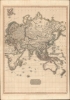
The eastern sheet offers coverage of most of Europe, Asia, the bulk of Africa, Australia, and Polynesia. In Europe, the Napoleonic Wars were nearing their zenith. Africa is mostly unexplored, but maintains speculative geography, including the supposed 'Mountains of the Moon' (likely reflecting indigenous reports of the Rwenzoris Mountains) and the Mountains of Kong (courtesy of Scottish explorer Mungo Park). Lake Malawi is recognizable and correctly located, although the image suggests a supposed connection with then speculative Lake Tanganyika. In India we can see the effective British cartographic efforts of James Rennell and others. Australia remains 'New Holland', although the still-young British colony of New South Wales is identified. Much of the western and southern parts nonetheless still rely on the geography of Dampier, Vancouver, and Cook. Both maps highlight the important maritime explorers of the latter 19th century, among them Cook and Vancouver.Publication History and Census
These maps were drafted by Lewis Hebert and engraved by Samuel John Neele in 1812 for issue in the 1815 first edition of John Pinkerton's A Modern Atlas. Both the maps and atlas are well represented institutionally but increasingly scarce on the market.CartographerS
John Pinkerton (February 17, 1758 - March 10, 1826) was an Scottish writer, historian, and cartographer. Pinkerton was born in Edinburgh, Scotland. He was a studious youth with a passion for the classics. As a young man, he studied at Edinburgh University before apprenticing as a lawyer. Around this time, he began writing, with his first book, Elegy on Craigmillar Castle published in 1776. Pinkerton moved to London in 1781 to pursue his writing career in earnest. He successfully published several works of literature, poetry, and history. Pinkerton proved passionate in his literary and historical writings, but his correspondence with other cartographers has been labeled as aggressive, even insane. In addition to his work as a writer and historian, Pinkerton was one of the leading masters of the Edinburgh school of cartography which flourished from roughly 1800 to 1830. Pinkerton and his contemporaries (Thomson and Cary) redefined European cartography by abandoning typical 18th century decorative elements such as elaborate title cartouches and fantastical beasts in favor of detail and accuracy. Pinkerton's principle work is Pinkerton's Modern Atlas published from 1808 through 1815 with a special American reissue by Dobson and Co. in 1818. Pinkerton relocated to Paris in 1818, where he managed his publishing business until his death in 1826. More by this mapmaker...
Lewis Hebert (fl. c. 1809 - 1842) was a British surveyor, cartographer, and draughtsman active in the early 19th century. Little is known of his life. He apparently was trained as a surveyor and worked as such under John Cary, where he also, perhaps became involved in engraving. He compiled or engraved numerous maps of John Cary, Sidney Hall, Richard Holmes Laurie, and others. Hins son, Lewis John Hebert (? - 1851) was also a draughtsman and lithographer. Learn More...
Samuel John Neele (July 29, 1758 - May 13, 1824) was a prolific British map engraver active in the late 18th and early 19th centuries. Neele apprenticed as a printer and engraver with Harry Ashby from about 1781 to 1782 before establishing himself independently in 1785 at 352 Strand, London. The combination of business acumen and technical skill made Neele extremely successful with literally hundreds of maps to his credit. His vast corpus was composed of notable maps by most major English publishers of the period including, Haywood, Faden, Wallis, Stockdale, Arrowsmith, Thomson, Pinkerton, and Greenwood, among others. Neele's sons, James and Josiah Neele, also engravers, took over their fathers business around 1818, both becoming notable in their own right. Learn More...
Source
Pinkerton, John, A Modern Atlas, from the Latest and Best Authorities, Exhibiting the Various Divisions of the World, with its Chief Empires, Kingdoms, and States; in Sixty Maps, carefully reduced from the largest and most authentic sources, (London: T. Cadell and W. Davies / Longman, Hurst, Rees, Orme, and Brown) 1815.
Condition
Very good. Some acid transference from older framing. Eastern Part exhibits some water damage right border, at center height. Size indicated references composite image, as shown.
References
Wheat, C. I., Mapping of the Transmississippi West, 1540 – 1861, #310. Rumsey 0732.062, 0732.063, 0732.064.