This item has been sold, but you can get on the Waitlist to be notified if another example becomes available, or purchase a digital scan.
1867 Hughes Map of the World According to the Ancients
WorldAnciets-hughes-1867$50.00

Title
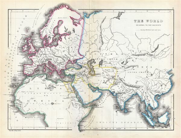
The World as known to the Ancients.
1867 (undated) 10 x 13 in (25.4 x 33.02 cm) 1 : 53000000
1867 (undated) 10 x 13 in (25.4 x 33.02 cm) 1 : 53000000
Description
This is an interesting 1867 map of the ancient World by William Hughes. The map covers Europe, Asia and Africa during the time of the Ancient Roman Empire. It depicts the world of antiquity from the Atlantic Ocean to China and from the Indian Ocean north as far as Norway. It includes all of Europe with most of Asia and Africa. The map also notes the boundary of the Persian Empire under Cyrus the Great. Founded by Cyrus the Great in the 6th century BCE, the First Persian Empire or the Achaemenid Empire was, at its height, the biggest Empire the world has ever seen.
In Africa, the author notes various cities from Ptolemy's Geographica, including Rapta (Rhaptus), Axum(Auxume), Garama, and others. The Libyan Desert is noted, and the continent itself is identified as 'Libya or Africa.' In the Far East a number of classical locales are noted, including the island of Taprobana (Celon). The map indicates the region of Sarmatia Europea separated from Sarmatia Asiatica by the River Tanais (River Don) in Russia. The map also shows Scythia Intra Imaum and Scythia Extra Imaum, the region of Scythia as it was known during the time of the Roman Empire, divided by Mount Imaum, denoting the whole of Northern Asia.
The Roman Empire was established in 27 BC after Gaius Julius Caesar Octavianus, the grandnephew and heir of Julius Caesar was awarded the honorific title of Augustus. During the time of the empire, Roman cities flourished. Trade spread as far as India, Russia, China and Southeast Asia. However, the sheer size of the empire and its success also contributed to its downfall. The Western Roman Empire collapsed in AD 476, when Romulus Augustulus was deposed by the German Odovacer. The eastern Roman Empire, evolving into the Byzantine Empire, survived until the Ottoman Turks captured Constantinople in 1453.
This map was created by William Hughes, printed by J. Bien and engraved by G.E. Sherman, for issued as plate 2 in Sheldon and Company's An Atlas of Classical Geography.
CartographerS
William Hughes (c. 1818 - May 21, 1876) was a cartographer, engraver, lithographer, printer, and publisher active in London during the middle part of the 19th century. Hughes enjoyed and long and varied cartographic career. He was elected a Fellow of the Royal Geographical Society in 1838 and, from about 1840, taught geography and mapmaking at St. Johns College for Civil Engineers. He later taught the same at both Queens College and Kings College, London. For a time he was employed as a map librarian for the British Museum. Hughes began engraving maps around 1839 and worked with most of the prominent British map and atlas publishers of his era, including but not limited to Charles Knight, A. and C. Black, George Philip, William Cassell, and others. More by this mapmaker...
Julius (Julien) Bien (September 27, 1826 - December 21, 1909) was a German-Jewish lithographer and engraver based in New York City. Bien was born in Naumburg, Germany. He was educated at the Academy of Fine Arts, Cassell and at Städel's Institute, Frankfurt-am-Main. Following the suppression of the anti-autocratic German Revolutions of 1848, Bien, who participated in the pan-German movement, found himself out of favor in his home country and joined the mass German immigration to the United States. Bien can be found in New York as early as 1849. He established the New York Lithographing, Engraving & Printing Company in New York that focused on the emergent chromo-lithograph process - a method of printing color using lithographic plates. His work drew the attention of the U.S. Government Printing Office which contracted him to produce countless government maps and surveys, including the Pacific Railroad Surveys, the census, numerous coast surveys, and various maps relating to the American Civil War. Bien also issued several atlases both privately and in conjunction with a relation, Joseph Bien. At the height of his career Bien was elected president of the American Lithographers Association. After his death in 1909, Bien's firm was taken over by his son who promptly ran it into insolvency. The firm was sold to Sheldon Franklin, who, as part of the deal, retained the right to publish under the Julius Bien imprint. In addition to his work as a printer, Bien was active in the New York German Jewish community. He was director of the New York Hebrew Technical Institute, the New York Hebrew Orphan Asylum, and president of the B'nai B'rith Order. Learn More...
Sherman and Smith (fl. c. 1829 - 1855), sometimes working as Stiles, Sherman & Smith, were American engravers active in New York City during the middle part of the 19th century. The firm including John Calvin Smith (surveyor and engraver), George E. Sherman, and sometimes, Samuel Stiles. Their work primarily focused on government publications, including the maps and engravings prepared to illustrate the official records of the 1838-42 United States Exploring Expedition (U.S. Ex. Ex.), maps issued for the Army Corps of Topographical Engineers, and various U.S. Coast Survey Charts. They also engraved privately for Thomas Bradford and John Disturnell, among others. Sherman and Smith maintained offices at the corner of Broadway and Liberty Street in New York City and were highly regarded as the finest cartographic engravers in the city. Their non-cartographic legacies include George Inness, who apprenticed with them for two years before going on to become a well regarding American landscape painter of the Hudson River School. Learn More...
Source
Sheldon and Company, An Atlas of Classical Geography constructed by William Hughes and edited by George Long, (New York) 1867.
Condition
Very good. Minor wear and toning along original centerfold.