This item has been sold, but you can get on the Waitlist to be notified if another example becomes available, or purchase a digital scan.
1588 Munster/ Petri set of World and Continents Maps
WorldContinentsSet-munsterpetri-1592$7,250.00


Title
Die erst General Tafel... Ptolemeisch General Tafel... Europa... Asia... Africa... Die newen Inseln.
1592 (undated) 12.5 x 14.25 in (31.75 x 36.195 cm)
1592 (undated) 12.5 x 14.25 in (31.75 x 36.195 cm)
Description
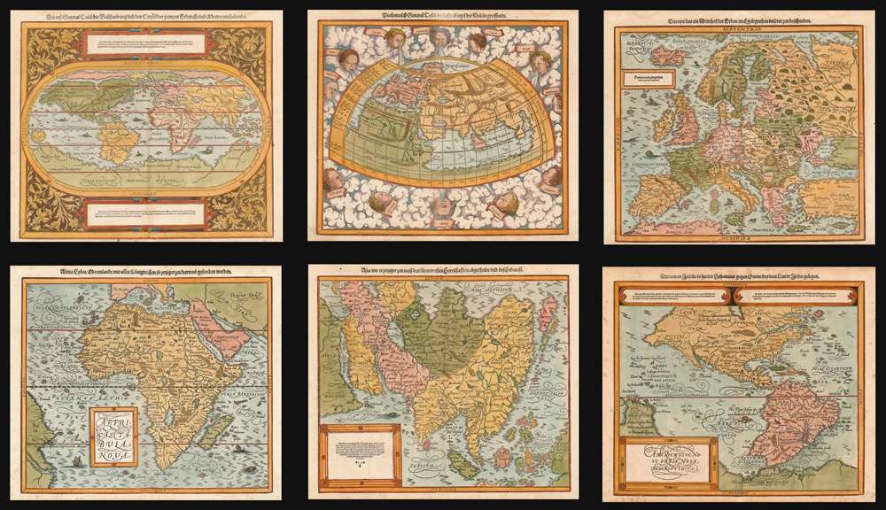
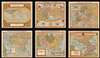
This is a beautiful, 6-map set of maps of the world and continents executed for 1588 and later editions of Sebastian Münster's magnum opus, Cosmographia Universalis, entitled in these later editions Cosmographey: das ist, Beschreibung Aller Länder, Herrschafften vnd fürnemesten Stetten des gantzen Erdbodens, sampt ihren Gelegenheiten, Eygenschafften, Religion, Gebräuchen, Geschichten vnd Handtierungen, [et]c. Beginning in 1544, this work would be the primary source of information for anyone who wished to know about the rest of the world: consequently its maps would have had a disproportionate impact, providing the first glimpse of remote and newly-discovered parts World to literate laypeople in Europe for more than half a century.
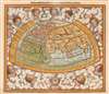
This was not the only cartographic depiction of Europe to appear in these editions of Cosmographey - there was also a half-sheet allegorical map showing Europe in the form of a queen, essentially a reduction of Heinrich Bünting’s full-sheet Europe map of 1581. This smaller map appeared in the body of the book, at the front of the section describing Europe.
Something Old, Something New
Depending on the edition, Münster's Cosmographiacontained between fourteen and twenty-eight 'foretext maps' (so called because of their position in the front of the book.) These remarkable and distinctive maps stand out as some of the first maps to show the areas they depicted. Cosmographia was an extremely successful work. Münster's printer, Heinrich Petri, continued to add material to the book even after Münster's death by plague in 1552. But during the 16th century new maps were being produced rapidly: Mercator's groundbreaking world map appeared in 1569, for example, and the first edition of Ortelius' Theatrum Orbis Terrarum would see the light of day in 1570. From that moment on, Münster's maps - especially those of the world and the continents - would be woefully out of date. Petri nevertheless produced editions of Cosmographia with the old maps until 1578. After his death in 1579, his son Sebastian realized that to continue to be competitive the work would need to be updated. In 1588 the fruits of that labor were revealed: the new edition of Cosmographey featured twenty-six newly cut foretext maps. These corresponded to the same regions depicted in the original editions, but were completely redrawn, drawing largely upon the maps appearing in the Ortelius atlas for geographical detail. Although derivative in content, these woodcut maps are beautifully executed and visually distinctive. The fine detail in the woodcutting surpasses any of Münster's own maps, reflecting both the advances in the art of xylography and the aesthetic influence from the copperplate engraving of the low countries. Note in particular the delicate Italic lettering, integral to the woodcuts, rather than the primitive stereotype lettering of the earlier Münster maps. It is a pity that the name of the artist who executed these beautiful woodcuts has not been preserved for posterity.The Modern World
The irony here is that in bringing Cosmographia's modern world map up to date, Petri has chosen the 1570 Ortelius as his model - which itself had been updated in 1587. (The 'potato' shape of South America is the main giveaway here.) Ortelius' map was itself a reduction of Mercator's monumental world map of 1569; like the Ortelius, Petri's map is a somewhat simplified reduction of its source. Mercator's four Arctic landmasses appear in the north, and a monumental Terra Australis dominates the southern portion of the map. Asia and North America are shown as separate continents, despite no evidence of the division until Cook's voyages in the late 18th century.The World of the Ancients
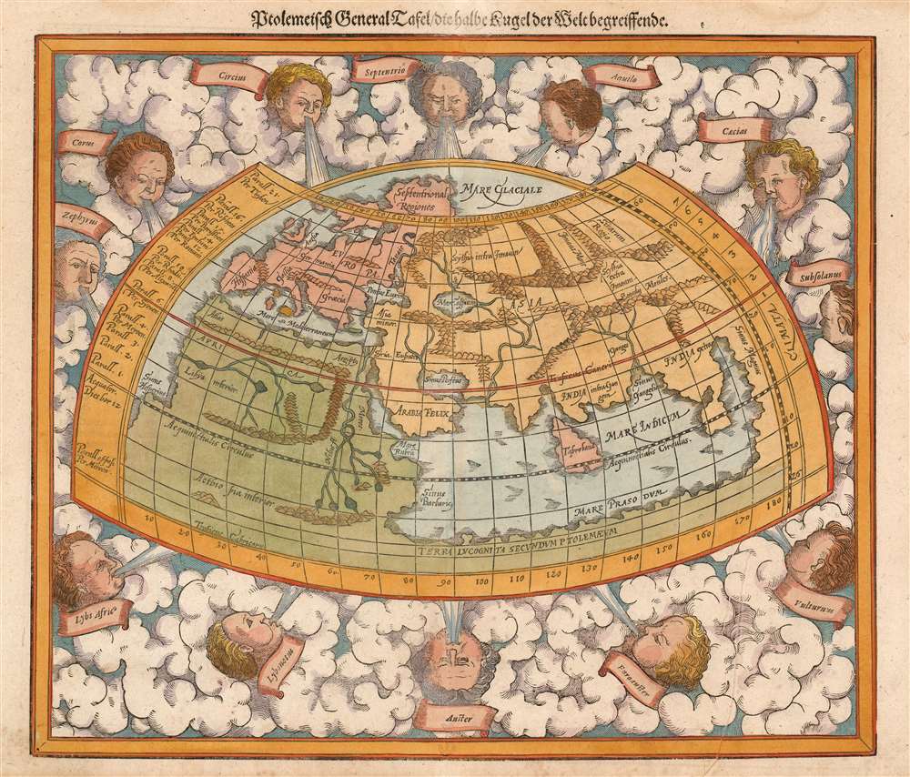
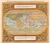
Scholarship of the 16th century depended less on innovation and more on the absorption and understanding of the work of earlier, established authorities: once these masters were fully comprehended, then new work could be achieved. For geographers in the 16th century, the reigning authority remained the 2nd century geographer and astronomer, Claudius Ptolemy. It was the rediscovery of Ptolemy's Geographia which provided the basis for all mathematical geography in the 15th and 16th century, and while the Alexandrian-Roman-Greek's data was plainly obsolete, his methodology for plotting out geographical locations on a grid remained the foundation for every map that followed. The first atlas-like works were simply printed editions of Ptolemy: these were followed by modernized 'Ptolemies' which combined the classic, 2nd century maps with maps using modern placenames and, increasingly, maps showing regions unknown to the Roman world. For the 16th century reader, the new discoveries were best understood in comparison with the assumptions of earlier geographers: thus, the inclusion of the Ptolemeisch General Tafel, showing the portions of Europe, Africa and Asia known to Ptolemy. Note, in particular, the land bridge of Terra Incognita Secundum Ptolemaeum connecting Africa with China. The Portuguese discovery that the Indian Ocean was not indeed landlocked, and that Africa was circumnavigable, is beautifully displayed by comparing the two world maps of this set. Also, in this land mass stretching from Africa to Asia we can see the seeds of the idea of the Terra Australis Nondum Cognita.Europe, The First Third of the World Described According to Our Times
This is the translation of the title of the map of Europe appearing in all German editions of Cosmographia. The southern-oriented map appearing in the 1544 - 1578 editions was remarkable for being the first generally acquirable modern depiction of the world, but by the end of its publication life this was no longer the case; in replacing the map with the present one, Petri again acknowledges the dominance - via Ortelius- of Mercator’s geographical model. The Mediterranean Sea dominates the south of the map, which extends far north to include Iceland (which did not appear on Münster's map) and a tantalizing glimpse of a northeast passage via the straits between Nova Zembla, Vaygach Island and Siberia. (It would take several attempts by the Dutch in the 1590s to determine that these straits were frozen solid more often than not: a poor alternative to the southern route to the Indies.)This was not the only cartographic depiction of Europe to appear in these editions of Cosmographey - there was also a half-sheet allegorical map showing Europe in the form of a queen, essentially a reduction of Heinrich Bünting’s full-sheet Europe map of 1581. This smaller map appeared in the body of the book, at the front of the section describing Europe.
The dominant mapping of Africa at the turn of the 16th Century
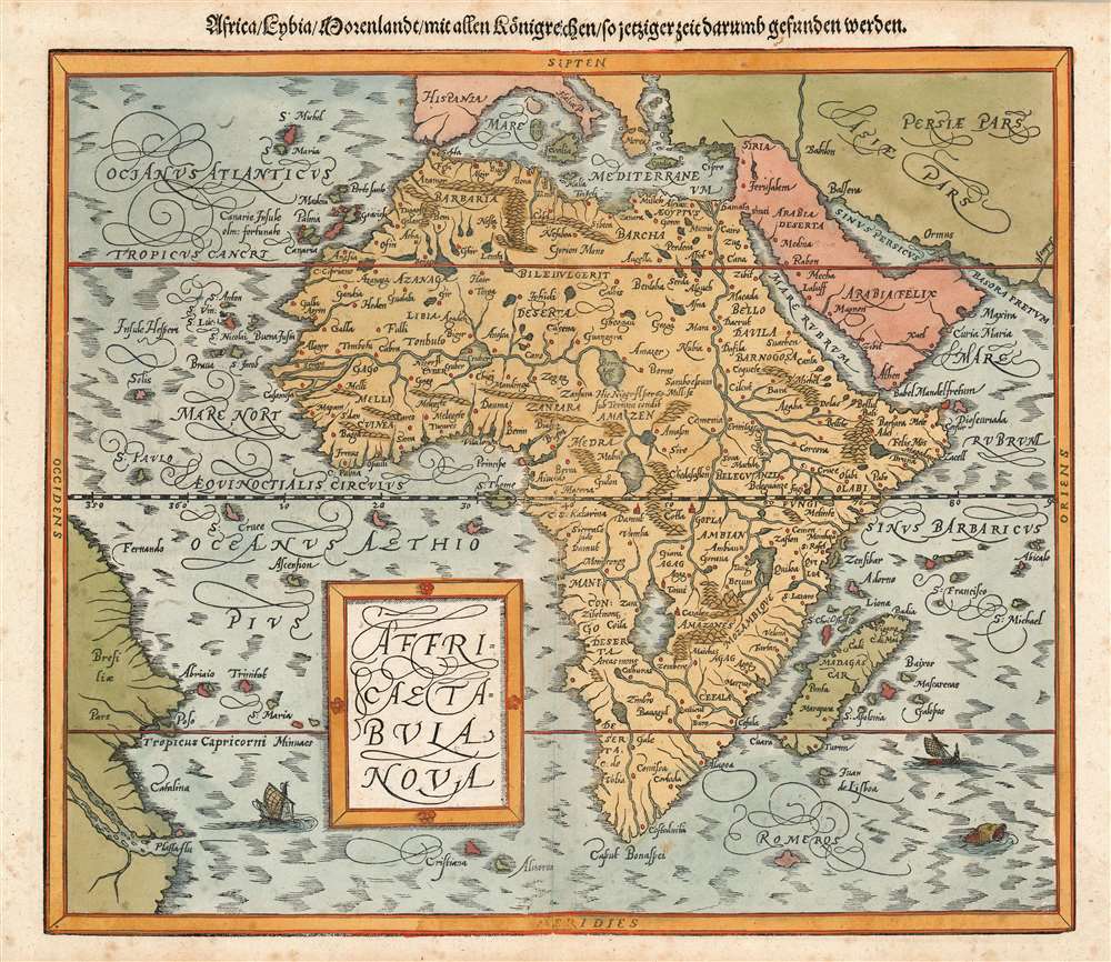
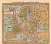
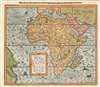
Ortelius’ map of Africa, first printed in 1570, represented the standard for the mapping of Africa at the time this woodcut was executed, and it would remain so for the rest of the century. Though necessarily lacking some of the fine detail afforded a copperplate engraving, this beautiful woodcut captures the essence of its model. The coastlines on this map reflect European knowledge of the Portuguese exploration of the coast, while the interior relies as heavily on ancient sources as much as did the map it replaced: the course of the Nile is based on Ptolemaic data here, just as it was on the original Münster map. As is the case with all the continental maps presented in this set, in addition to the lovely calligraphic flourishes the map is decorated with sea monsters and sailing ships. A note on dating: Betz catalogues an example of the Africa map, with comparable verso printing to this one, as a 1598 issue, but we find a similar map appears in the 1592 Cosmographey in the Bayerische Staatbibliothek, and are therefore confident with the earlier date.Mapping India, Asia and the Far East
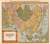
To our eyes, this map can seem more distorted than it actually is - Petri’s rendition of Ortelius’ map lacks latitude and longitude lines, so the projection used for the map is not apparent. Even considering that, it must be admitted the extent to which the map becomes less accurate as one progresses eastwards. China does not bulge as it should, and the depiction of Japan - apart from the indication that the island existed - is not reflective even of cartographic information that appeared in Ortelius atlases of the 1580s. In spite of this, the map’s treatment of India and Southeast Asia is reasonably accurate. Just as is the case with the Europe map, this one preserves Ortelius’ clearly-presented sea passage north of Asia.The Map of the Americas
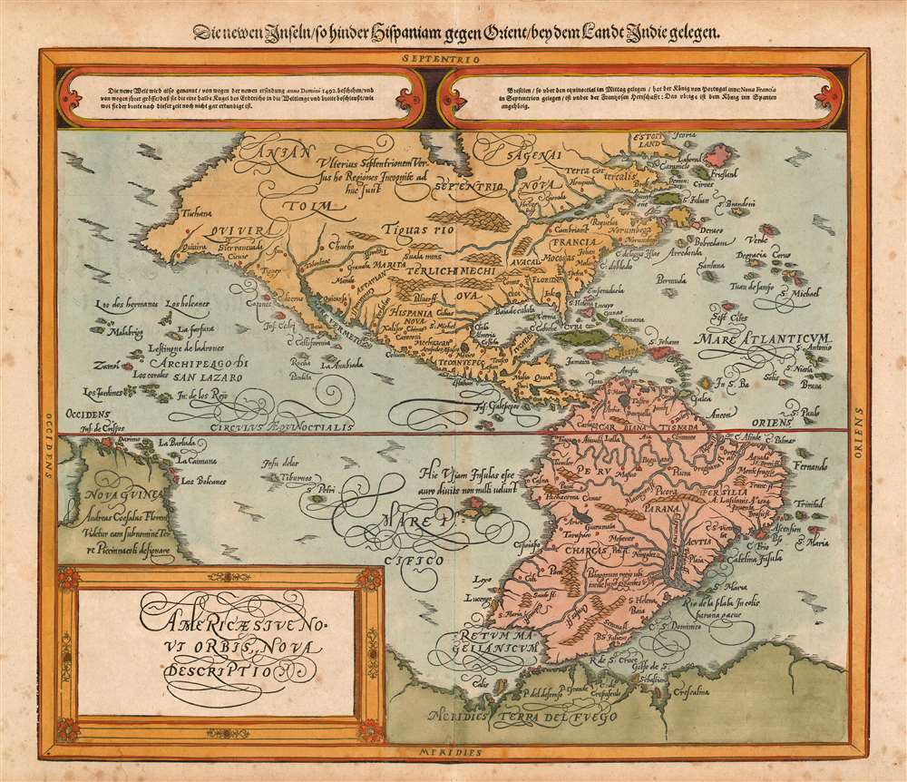
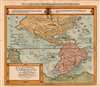
Perhaps more than any of Münster’s continents maps, his map of the western hemisphere was in direst need of update. Groundbreaking though that map was, Ortelius’ synthesis of Portuguese and Spanish sources - both his own and Mercator’s - would render the earlier work charmingly obsolete. Here, even considering the detail elided by the xylographer, the Spanish-conquered areas of California, Mexico, the West Indies and South America are quite recognizable and well presented. A note on dating: although there appears to be only one state of this map, typographic variations in the verso text and decoration lead us to identify this sheet as having been produced in 1588 for the first Sebastian Petri edition of Cosmographey, rather than 1592. As the text content of the two editions is essentially the same, it is entirely credible that sheets remaining unbound from the 1588 run might have been utilized in subsequent editions. We cannot, however, discount the possibility that this sheet originated from a different example of the work.Publication History and Census
Despite the advent of the modern atlas with Ortelius, Petri’s late editions of Cosmographey were successful, and separate examples of these maps appear on the market in varying condition. The book, sometimes bound in multiple volumes, is well represented in institutional collections. Attractive sets, comparable to this, are desirable and difficult to find.CartographerS
Sebastian Münster (January 20, 1488 - May 26, 1552), was a German cartographer, cosmographer, Hebrew scholar and humanist. He was born at Ingelheim near Mainz, the son of Andreas Munster. He completed his studies at the Eberhard-Karls-Universität Tübingen in 1518, after which he was appointed to the University of Basel in 1527. As Professor of Hebrew, he edited the Hebrew Bible, accompanied by a Latin translation. In 1540 he published a Latin edition of Ptolemy's Geographia, which presented the ancient cartographer's 2nd century geographical data supplemented systematically with maps of the modern world. This was followed by what can be considered his principal work, the Cosmographia. First issued in 1544, this was the earliest German description of the modern world. It would become the go-to book for any literate layperson who wished to know about anywhere that was further than a day's journey from home. In preparation for his work on Cosmographia, Münster reached out to humanists around Europe and especially within the Holy Roman Empire, enlisting colleagues to provide him with up-to-date maps and views of their countries and cities, with the result that the book contains a disproportionate number of maps providing the first modern depictions of the areas they depict. Münster, as a religious man, was not producing a travel guide. Just as his work in ancient languages was intended to provide his students with as direct a connection as possible to scriptural revelation, his object in producing Cosmographia was to provide the reader with a description of all of creation: a further means of gaining revelation. The book, unsurprisingly, proved popular and was reissued in numerous editions and languages including Latin, French, Italian, and Czech. The last German edition was published in 1628, long after Münster's death of the plague in 1552. Cosmographia was one of the most successful and popular books of the 16th century, passing through 24 editions between 1544 and 1628. This success was due in part to its fascinating woodcuts (some by Hans Holbein the Younger, Urs Graf, Hans Rudolph Manuel Deutsch, and David Kandel). Münster's work was highly influential in reviving classical geography in 16th century Europe, and providing the intellectual foundations for the production of later compilations of cartographic work, such as Ortelius' Theatrum Orbis Terrarum Münster's output includes a small format 1536 map of Europe; the 1532 Grynaeus map of the world is also attributed to him. His non-geographical output includes Dictionarium trilingue in Latin, Greek, and Hebrew, and his 1537 Hebrew Gospel of Matthew. Most of Munster's work was published by his stepson, Heinrich Petri (Henricus Petrus), and his son Sebastian Henric Petri. More by this mapmaker...
Heinrich Petri (1508 - 1579) and his son Sebastian Henric Petri (1545 – 1627) were printers based in Basel, Switzerland. Heinrich was the son of the printer Adam Petri and Anna Selber. After Adam died in 1527, Anna married the humanist and geographer Sebastian Münster - one of Adam's collaborators. Sebastian contracted his stepson, Henricus Petri (Petrus), to print editions of his wildly popular Cosmographia. Later Petri, brought his son, Sebastian Henric Petri, into the family business. Their firm was known as the Officina Henricpetrina. In addition to the Cosmographia, they also published a number of other seminal works including the 1566 second edition of Nicolaus Copernicus's De Revolutionibus Orbium Coelestium and Georg Joachim Rheticus's Narratio. Learn More...
Abraham Ortelius (April 14, 1527 - June 28, 1598) also known as Ortels, was a cartographer, geographer, and cosmographer of Brabant, active in Antwerp. He was the creator of the first modern atlas, Theatrum Orbis Terrarum and is a seminal figure in the history of cartography. Along with Gerard Mercator and Gemma Frisius, he was a founder of the Netherlandish school of cartography. His connections with Spain - culminating in his 1575 appointment as Royal Cartographer to King Phillip II of Spain - gave him unmatched access to Spanish geographical knowledge during a crucial period of the Age of Discovery. Ortelius was born in 1527 in Antwerp. In 1547 he entered the Antwerp Guild of Saint Luke as an illuminator of maps. He began trading in books, prints, and maps, traveling regularly to the Frankfurt book and print fair, where in 1554 he met Mercator. He accompanied Mercator on journeys throughout France in 1560 and it was at this time, under Mercator's influence, that he appears to have chosen his career as a scientific geographer. His first published geographic work appeared in 1564, an eight-sheet cordiform world map. A handful of other maps preceded the 1570 publication of the first edition of the Theatrum Orbis Terrarum, which would prove to be his life work. Appearing with but 53 maps in its first edition, Ortelius' work expanded with new maps added regularly. By 1592, it had 134 maps. Many of Ortelius' maps remained the standard for nearly a century. He traveled extensively, but his genius was as a compiler, locating the best informed maps on which to base his own. His contacts throughout Europe and extending even (via the Portuguese) to the Far East were formidable. Moreover, many of his maps were based on his own scholarship, particularly his historical works. His theories of geography were particularly ahead of his time with respect to the notion of continental drift, the possibility of which he mused on as early as 1596, and which would be proven correct centuries later.
In a sense his greatest achievement was his successful navigation of the religious and political violence endemic to his city throughout his adult life: The Dutch Revolt, or Eighty Years' War (1568 - 1648), fully embroiled Antwerp. Although outwardly and officially recognized as Catholic (Arias Montanus vouched for Ortelius' Catholic orthodoxy prior to his appointment as Royal Geographer), Ortelius was able to separate himself from the religious furor which characterized the war in the low countries. Ortelius showed a glimpse of himself in a letter to a friend, regarding humanist Justus Lipsius: 'I do not know whether he is an adherent of the Pope or a Calvinist, but if he has ears to hear, he will neither be one nor the other, for sins are committed on both sides'. Ortelius' own explorations of Biblical history in his maps, and the Christogram contained in his own motto, suggest him to be a religious man, but his abjuration of political religious authorities mark him as an individualist. His tombstone at St Michael's Præmonstratensian Abbey in Antwerp bears the inscription, Quietis cultor sine lite, uxore, prole. ('served quietly, without accusation, wife, and offspring.') Learn More...
Source
Munster, S. Cosmographey... (Basel: Petri, S.) 1592.
The Cosmographia Universalis, one of the greatest geographical and historical works of the 16th century, 'taught nearly three generations of laymen most of what they knew about the world beyond their native places' (Strauss). Filled with maps, views, and rich descriptions of places throughout Europe and beyond, it was the best general source of geographical information until the advent of Ortelius' Theatrum. It was first issued by Sebastian Munster (1488 - 1552) in its 1544 German edition, and stayed in print long after its author's death in thirty five editions, and in five languages. (Of these, the 1550 and 1552 editions are widely regarded as the most complete and truest to the author's intentions: thereafter, later editors continued to add to the work's text; editions from 1588 onwards employed an entirely different set of maps produced on Ortelius' model.) Munster's goal, initially, was to rally his homeland's humanists and scholars to produce a new map of Germany in order to 'see what kind of a land our ancestors conquered for their home... bring honor to our country and place its beauties in the clear light of day.' Munster's project quickly expanded to cover the known world in its scope to produce a 'sufficiently large volume, in which I touch upon the foundation of all nations and kingdoms, their peculiarities, rivers, mountains, customs of men, royal successions, origins of the more important cities, succinct histories, religions, characteristics and fertility of lands... in Germany, however, I tarry a little longer'.
Munster's methodology in Cosmographia is notable in particular for his dedication to providing his readers with direct access to firsthand reports of his subjects wherever possible. Many of the maps were the result of his own surveys; others, the fruit of an indefatigable letter writing campaign to scholars, churchmen and princes throughout Europe, amicably badgering them for maps, views, and detailed descriptions of their lands. For lands further afield than his letters could reach, Munster relied on the best that the authorities of northern European scholarship could offer: he was well familiar with the work of Waldseemuller and other geographers of the early 16th century, and was well connected with the best geographers of his own generation. A disproportionate number of the maps of Cosmographia show contemporary geographical knowledge of the their respective areas for the very first time: The first map to show the continents of the Western Hemisphere; the first map to focus on the continent of Asia; the first modern map to name the Pacific Ocean; the first map to use a key; the first modern map of the British Isles and so on. Even in cases where earlier maps exist, Munster's works very often remain the earliest such acquirable by the collector.
Munster's methodology in Cosmographia is notable in particular for his dedication to providing his readers with direct access to firsthand reports of his subjects wherever possible. Many of the maps were the result of his own surveys; others, the fruit of an indefatigable letter writing campaign to scholars, churchmen and princes throughout Europe, amicably badgering them for maps, views, and detailed descriptions of their lands. For lands further afield than his letters could reach, Munster relied on the best that the authorities of northern European scholarship could offer: he was well familiar with the work of Waldseemuller and other geographers of the early 16th century, and was well connected with the best geographers of his own generation. A disproportionate number of the maps of Cosmographia show contemporary geographical knowledge of the their respective areas for the very first time: The first map to show the continents of the Western Hemisphere; the first map to focus on the continent of Asia; the first modern map to name the Pacific Ocean; the first map to use a key; the first modern map of the British Isles and so on. Even in cases where earlier maps exist, Munster's works very often remain the earliest such acquirable by the collector.
Condition
Very good condition. Light toning, fine hand color.
References
OCLC 79422854 (1588), 163162460 (1588), 163162466 (1588), 163163398 (1588), 182560528 (1588), 53935167 (1588). Shirley, Rodney W., The Mapping of the World: Early Printed World Maps 1472-1700, 162, 163. Betz, R., The Mapping of Africa A Cartobibliography of Printed Maps of the African Continent to 1700, 21. Burden, P., The Mapping of North America, 67.