
1930 Osaka Mainichi Shinbun World Map Sugoroku

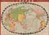

世界航空路圖 / Sekai kōkūrozu. / World Aviation Route Map. / 征空すごろく/ Seikū su-goro ku.
Graphically wonderful Japanese world aviation board game.
- Digital Map Information
- Suitable for large format printing
- File Size: 212.57 MB
- File Type: ZIP / TIFF
- ICC color profile embedded
- Delivered instantly via download link
Graphically wonderful Japanese world aviation board game.
This is a 1930 Osaka Mainichi Shinbun world aviation map and sugoroku game that brings the record-breaking flights of the 1920s into the Japanese home. Issued for New Year's Day, when major newspapers like the Osaka Mainichi would often publish sugoroku supplements, it invites players to explore an interconnected world by airplane and airship, combining aviation history, geographical instruction, and family entertainment. Its prominent Zeppelin route had particular relevance to the publisher: an Osaka Mainichi correspondent had traveled aboard the Graf Zeppelin during its celebrated round-the-world journey in 1929.A Closer Look
The world appears on a Japan-centered oval projection, with Eurasia and Africa to the left and the Americas to the right. Contrasting country colors and national flags establish the political geography, while red aviation routes dominate the composition. Airplanes, flying boats, and elongated airships punctuate the oceans, giving recognizable forms to the different technologies competing to overcome distance, a contest whose outcome was by no means considered a foregone conclusion at the time. The legend distinguished between exceptional flights and repeatable transportation. Heavy segmented lines identify famous long-distance flights, with a related symbol distinguishing stretches also used by scheduled services. Thinner solid, dashed, and dotted lines differentiate scheduled routes, routes already flown, and projected routes.Among the historic flights represented are the United States Army Air Service's 1924 circumnavigation, Charles Lindbergh's solo Atlantic crossing of May 20 - 21, 1927, the airship Italia's 1928 North Polar expedition, and the Graf Zeppelin's 1929 circumnavigation. The upper-right text surveys major aviation journeys, while the upper-left section assembles records for speed, endurance, altitude, and distance. Together, these columns turn the game board into a compact reference to contemporary aeronautical achievement.
A ring of 52 numbered photographic vignettes supplies a second itinerary. Beginning with Osaka's Nakanoshima district, it passes through Chinese monuments, Siberian railways, European cities, African landscapes, Asian temples, Pacific islands, and the Americas before returning to Tokyo. The imagery moves freely between engineering, natural history, architecture, and popular culture: the Forth Bridge and Panama Canal share the border with a zebra, kangaroo, polar bear, and Hollywood actress Clara Bow. Her portrait makes cinema another destination in this armchair tour, alongside mountains, capitals, and archaeological monuments.
From Newspaper Event to Family Game
In August 1929, the German rigid airship Graf Zeppelin (LZ 127), commanded by Hugo Eckener (1868 - 1954, long-time manager of the Luftschiffbau Zeppelin), completed the first passenger-carrying circumnavigation of the globe. Largely financed by American newspaper publisher William Randolph Hearst in exchange for exclusive reporting rights, the official voyage began and ended at Naval Air Station Lakehurst in New Jersey, with intermediate stops in Friedrichshafen, Tokyo, and Los Angeles. Covering 20,651 miles (33,234 km) in 21 days, 5 hours, and 31 minutes—with an actual airborne flight time of just 12 days—the historic expedition shattered global travel records and transfixed international audiences, briefly establishing the airship as the pinnacle of long-distance intercontinental transit.The Graf Zeppelin's visit to Japan was an immediate news sensation. During its stop at Kasumigaura from August 19 - 23, 1929, more than 300,000 spectators came to see the airship. Newspapers followed its progress closely, and Osaka Mainichi correspondent Enchi Yoshimatsu (円地与四松, 1895 - 1972), who joined the flight in Germany, regularly sent dispatches to Japan from aboard.
Several Ways Around the World
This sheet is intended for sugoroku, more specifically e-sugoroku (繪双六). Historically, there are two variants of sugoroku, one that is similar to backgammon, and the presently offered 'snakes and ladders' style variant. This version of the game appeared as early as the 13th century and was popularized by the rise of printing technology, especially in the Edo and Meiji periods, leading to the production of high-quality, visually arresting gameboards. A standard sugoroku board has a starting point, the furi-dashi, and a winding or spiral path terminating at the agari (上利 / 上リ) or finish line. Many sugoroku had an educational or didactic purpose and were geared towards inculcating patriotism and good morals in children, especially in the Meiji period. Sugoroku can be played at any time of year, but is a traditional pastime associated with Oshogatsu, the Japanese New Year, leading the Osaka Mainichi and other leading newspapers of the era to publish eye-catching supplements for their subscribers.The instructions here offer substantially more than a single race along a fixed track. In the simplest version, players follow the numbered border photographs from Osaka to Tokyo, advancing by die throws. An exact throw is required to finish, with an overshoot sending the player backward. A more geographical version moves play onto the aviation routes within the map, allowing players to choose their connections. Other variants require visits to six capitals - London, Paris, Berlin, Rome, Moscow, and Washington - or a circumnavigation incorporating an Atlantic crossing.
The exploration variant adds remote destinations and obstacles. Polar regions, the Sahara, the Amazon's forests, and New Guinea become objectives, while mountain crossings can require a landing and repairs. Players are encouraged to combine conditions or devise additional rules. This flexibility makes geographical decisions part of the entertainment: the map is both the subject being learned and the network through which the game proceeds. The closing instructions solicit reports of successful adventures and explorations, extending the newspaper's relationship with its young readers beyond the initial distribution of the sheet.
Publication History and Census
This map was compiled by the Osaka Mainichi Shinbun and issued on January 1, 1930 (Showa 5), as its New Year's supplement. The lower-right imprint credits the Seiban Printing Company as printer. It is cataloged among the holdings of the David Rumsey Historical Map Collection, Harvard University, Princeton University, Carleton College, and the National Library Board in Singapore, as well as the National Diet Library, Ritsumeikan University, and the Mie Prefectural Museum.Cartographers
The Osaka Mainichi Shimbun (大阪毎日新聞; 1876 - 1942) was an Osaka based daily newspaper active in the late 19th and early 20th century. The Osaka Mainichi Shimbun (大阪毎日新聞, Osaka Daily News) was founded in 1876 as Osaka Nippo(大阪日報). In 1888 it was renamed Osaka Mainichi Shimbun. In 1911 it merged with the Tokyo Nichi Nichi Shimbun (東京日日新聞), but both companies continued to print their newspapers independently until 1943, they were consolidated under the Mainichi Shimbun (毎日新聞, Daily News) masthead. The Mainichi Shimbun is today one of Japans larges and longest lasting newspapers. Further Details...
Seiban Printing Co. (精版印刷株式會社; fl. c. 1925 - 1945) was an Osaka-based publisher in the early Showa period. A number of contemporaneous publishing houses used Seiban (or Seihan) in their name (帝国精版印刷, 京都精版印刷社, 日本精版印刷), but were evidently distinct from this publishing house, which specialized in producing maps of the Japanese Empire (such as Manchukuo and occupied areas of China), often for the Osaka Mainchi Shimbun. The company published its own brief history in English in 1929 (A brief history of the Seihan Printing Company Limited, OCLC 843142406), suggesting that the company had already existed for some time by that point. Further Details...
Source
Osaka Mainichi Shinbunsha, Osaka Mainichi Shinbun, no. 16755, New Year's supplement, (Osaka: Osaka Mainichi Shinbunsha, January 1, 1930).
Condition
Good. Some wear along original fold lines. Professionally flattened and backed with archival tissue. Small areas of loss at fold intersections.
References
OCLC 941281151, 945189709, 1340394740. Rumsey, 7926.000.