This item has been sold, but you can get on the Waitlist to be notified if another example becomes available, or purchase a digital scan.
1924 Ogawa Jihei and Maekawa Senpan Cartoon Map of the World
WorldManga-ogawajihei-1924-2$700.00


Title
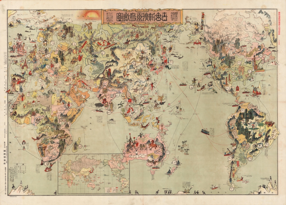
世界新漫画鳥瞰圗 / New Cartoon View of the World. / Sekai Shin Manga Chōkanzu.
1924 (dated) 29 x 42 in (73.66 x 106.68 cm) 1 : 23250000
1924 (dated) 29 x 42 in (73.66 x 106.68 cm) 1 : 23250000
Description
This is a rare Taisho 13 or 1924 Japanese manga or cartoon map of the world by artists Maekawa Senpan and Ogawa Jihei, published by Toshiaki Ishihara as a supplement to the New Year's edition of the magazine International Graphic (国際写真情報). Though exaggerated and in some cases disparaging of other cultures and countries, the map also reflects the simultaneous arrogance and anxieties of interwar Japanese nationalism.
There are a few political references, particularly in China, where north and south China are shown in a tug of war battle, a reference to infighting between regional warlords. Meanwhile, a sickly figure in southern China drinks from a bottle labelled 'opium.' The map also alludes to the Japanese population in Hawaii and Southeast Asia. In addition, there are historical notes throughout, identifying the landing place of Christopher Columbus, St. Helena where Napoleon was exiled, and more.
The more negative aspects of the map include its illustration of Russia, with a chained slave populace, military aggression, and a rabid tiger bearing a bloody saber north of Manchuria. Not only had Japan defeated Russia, at great cost, in the Russo-Japanese War of 1904-1905, but it had also intervened in the Russian Civil War, occupying much of the eastern portion of the Trans-Siberian Railway to prevent it falling into Bolshevik hands. Below the title, a Bolshevik madman rides an eastbound Trans-Siberian train, wildly distributing propaganda leaflets (the 'redification' of Asia was a frequent bugbear in Japanese public discourse in these years).
Taiwan, then part of the Japanese Empire, is illustrated by a spear-wielding savage, clearly a derogatory reference to the aboriginal peoples of eastern Taiwan. A Korean figure on the border of Manchuria appears as a bomb-wielding maniac. Attempted assassinations of Japanese politicians and military leaders by Korean nationalists were common at this time (Korea was under brutal Japanese colonial occupation), but this figure likely refers specifically to the assassination of senior statesman and architect of modern Japan Itō Hirobumi by An Jung-geun in Harbin in 1906. Given Japan's alignment with the Allied or Entente powers in World War I, the map also appears to reference the Armenian genocide with a bloodied sword directed towards Armenia, while Germany is gloomily represented by a skull sitting on a pile of books.
In 1932 Shishido Sakō (宍戸左行) redrew this map with a darker more militant message. On that map, the United States is no longer the land of fun and sports, instead bloated politicians and capitalists sit in New York and Washington, racist imagery appears in the south, and Chicago's criminal bootleggers are in cages. Political figures like Stalin, Hitler, Franco, and Mussolini make appearances. In that later edition, the pleasure craft, merchant ships, and fishermen on this map are replaced with battleships.
A Closer Look
Centered on Japan, the map covers most of the globe with the exception of the Atlantic Ocean. Cartoon figures illustrate geography, culture, historical events, flora, fauna, and more. Predating the greater hostilities of World War II, this map exhibits a fairly friendly and open-minded worldview, at least towards most parts of the world. Scotland is described as having kind people and being 'beautiful, similar to Japan.' France is a land of wine, art, and fashion. The United States is a place of rich agriculture, shingling skyscrapers, scenic beauty, and sports, including tennis, boxing, and baseball, though some mention is made of the odd curiosities (real or imagined) of contemporary America, such as Prohibition and polygamy in Utah. In the Amazon there is a great anaconda snaking about the river itself. Canada is mostly forests and lumberjacks.There are a few political references, particularly in China, where north and south China are shown in a tug of war battle, a reference to infighting between regional warlords. Meanwhile, a sickly figure in southern China drinks from a bottle labelled 'opium.' The map also alludes to the Japanese population in Hawaii and Southeast Asia. In addition, there are historical notes throughout, identifying the landing place of Christopher Columbus, St. Helena where Napoleon was exiled, and more.
The more negative aspects of the map include its illustration of Russia, with a chained slave populace, military aggression, and a rabid tiger bearing a bloody saber north of Manchuria. Not only had Japan defeated Russia, at great cost, in the Russo-Japanese War of 1904-1905, but it had also intervened in the Russian Civil War, occupying much of the eastern portion of the Trans-Siberian Railway to prevent it falling into Bolshevik hands. Below the title, a Bolshevik madman rides an eastbound Trans-Siberian train, wildly distributing propaganda leaflets (the 'redification' of Asia was a frequent bugbear in Japanese public discourse in these years).
Taiwan, then part of the Japanese Empire, is illustrated by a spear-wielding savage, clearly a derogatory reference to the aboriginal peoples of eastern Taiwan. A Korean figure on the border of Manchuria appears as a bomb-wielding maniac. Attempted assassinations of Japanese politicians and military leaders by Korean nationalists were common at this time (Korea was under brutal Japanese colonial occupation), but this figure likely refers specifically to the assassination of senior statesman and architect of modern Japan Itō Hirobumi by An Jung-geun in Harbin in 1906. Given Japan's alignment with the Allied or Entente powers in World War I, the map also appears to reference the Armenian genocide with a bloodied sword directed towards Armenia, while Germany is gloomily represented by a skull sitting on a pile of books.
In 1932 Shishido Sakō (宍戸左行) redrew this map with a darker more militant message. On that map, the United States is no longer the land of fun and sports, instead bloated politicians and capitalists sit in New York and Washington, racist imagery appears in the south, and Chicago's criminal bootleggers are in cages. Political figures like Stalin, Hitler, Franco, and Mussolini make appearances. In that later edition, the pleasure craft, merchant ships, and fishermen on this map are replaced with battleships.
Publication History and Census
This manga map was drawn by Maekawa Senpan (前川千帆) and Ogawa Jihei (小川治平). It was printed by Ōtsu Yonezō (大津米造) of the Sanken Printing Company (三間印刷合名會社) and published by Toshiaki Ishihara (石原俊明) in the 1924 New Year's edition of International Graphic (国際写真情報), a monthly public affairs magazine with a strong visual element published between 1922 and 1968. This map is only cataloged among the holdings of the National Library of Australia, the National Museum of Taiwan History, the Fukui Prefectural Library and Archives, and the Nichibunken (International Research Center for Japanese Studies).CartographerS
Ogawa Jihei (小川治平, 1887 - 1925) was a Japanese political satirist, caricaturist and manga artist (cartoonist) active in the late 19th and early 20th centuries. Ogawa was born in Yatsugura, Saitama Prefecture, Japan in Meiji 20, or 1887. He worked with Kitazawa Rakuten (北沢楽天, 1876-1955) Jiji Shinpōsha's (時事新報社) Jiji Manga (時事漫画 ) magazine from 1921 to his death in 1924. More by this mapmaker...
Maekawa Senpan (前川千帆, October 5, 1888-1960) was a Japanese printmaker, artist, and cartoonist active in the first half of the 20th century. Maekawa was born in Kyoto, the younger brother of print-artist, Asaga Manjiro (1885-1965). From about 1905 he studied with Asai Chu (1856-1907) at the Kansai Bijutsuin (Kansai Fine Art Academy). In 1911 he relocated to Tokyo, taking work as a charicaturist and cartoonist for the Yomiuri Shinbun, the Kokumin Shinbun, and for Tokyo Pakku (Tokyo Puck). While in Tokyo, he thought himself woodblock printing and was a member of the Japanese Print Association from 1931 – 1960. During World War II, he was active with the Nihon Manga Hōkō Kai, a government sponsored cartoonists society organized to support the war effort. He was a staunch traditionalist while at the same time a political radical. Artistically, Maekawa was connected to the Sōsaku-hanga (創作版画) movement. Following the war his work became popular with the occupying forces and was repressed in several international exhibits, earning him global recognition. Learn More...
Toshiaki Ishihara (石原俊明, January 21, 1888 – January 17, 1973) was a Japanese businessman, publisher, and newspaperman active in the early to middle 20th century. For a time was a monk of Zen Buddhism. Toshiaki was born in Kakogawa City, Shizuoka, Japan. During the pre-war period he published various scientific journals. In 1922 he founded the International Information Agency (國際情報) , which published until 2002. After World War II, in 1851 he restructured the International Information Company. In, 1966 he launched the Taiwanese Company Limited Company and in 1969, Ishihara Shokai Kaikai. He died of heart failure in January of 1973. Learn More...
Condition
Good. Soiling and areas of discoloration, most noticeable in the margins.
References
OCLC 1020941189. National Library of Australia, MAP G3200 1924. National Museum of Taiwan History Registration Number 2020.006.0093.