This item has been sold, but you can get on the Waitlist to be notified if another example becomes available, or purchase a digital scan.
1850 Ensign and Thayer Wall Map of the World
WorldMercator-ensignthayer-1850$1,250.00

Title
Map of the World, on Mercators Projection.
1850 (dated) 31 x 46 in (78.74 x 116.84 cm) 1 : 36000000
1850 (dated) 31 x 46 in (78.74 x 116.84 cm) 1 : 36000000
Description
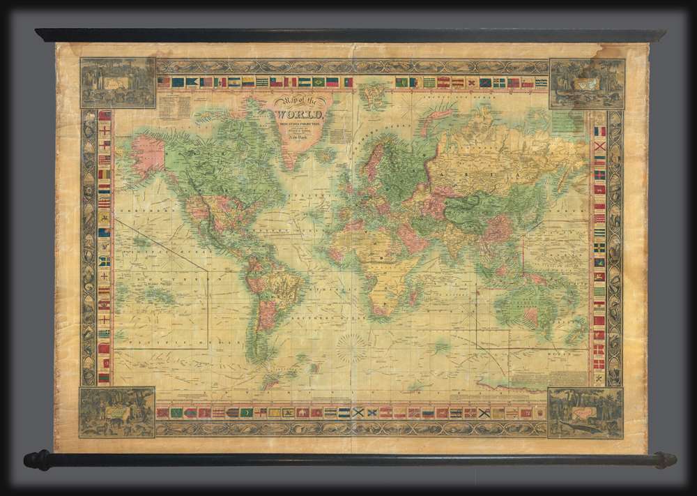
An attractive 1850 wall map of the world by the New York firm of Ensign and Thayer. The map presents the entire world on a Mercator Projection. It is surrounded by ensigns or flags of major maritime powers as well as an unusual decorative border defined by seashell vignettes. Different countries are highlighted by color, except the United States, wherein the individual states have their own color defination. The map meticulously details the routes of important explorers, including Christopher Columbus’ first voyage John and Sebastian Cabot, Vasco de Gama, Magellan, Sir Francis Drake, Commodore Anson, Captain James Cook, Captain Jean de la Perouse, Captain George Vancouver, and the United States Exploring Expedition (U.S. Ex. Ex.). In California, the Gold Region, reflecting general interest in the 1849 California Gold Rush, is noted. Texas is illustrated according to the Compromise of 1850, thus underscoring the cartographers' meticulousness in updating their maps.
Publication History and Census
This map was first published by Phelps and Ensign in 1841. It subsequently underwent numerous updates under various 'Ensign' related partnerships, including T. and E. H. Ensign, and, as here, Ensign and Thayer. Ensign and his various partners were responsible for some of the most unusual and decorative American wall maps of the mid-19th century. While the Ensign firm was prolific, producing a wide variety of maps, his individual publications were invariably small runs and are almost universally quite scarce. This map is no exception with only two cited references in the OCLC and no record on the private market.CartographerS
Edward Hooker Ensign (August 18, 1818 - July 10, 1871) was an American map and print publisher based in New York during the middle part of the 19th century. Edward was born in West Hartland, Connecticut. Little is known of Ensign's training but he may have inherited his business from his father, Timothy Ensign (1795 - 1859), who was a map publisher active in New York. Ensign seems to have had a flair for partnerships and variously published with Humphrey Phelps (1799 - 1875), Horace Thayer, Thomas C. Fanning (1805 - 1873) and Erastus C. Bridgman (1817 - 1870), among others. His various imprints include 'Phelps and Ensign' (1841-1844), 'T. and E. H. Ensign' (1844-1848), 'Ensign and Thayer' (1849), 'Ensign, Thayer, and Company' (1850-1851), 'Horace Thayer and Company' (1852), and 'Ensign, Bridgman and Fanning' (1854-1863). It appears that father and son worked together for some time as well, publishing as either 'T. and E. H. Ensign' or 'Ensigns'. At least some of these companies maintained offices in both Buffalo and New York City. More by this mapmaker...
Horace Thayer (June 29, 1811 - March 15, 1875) was a New York based publisher and lithographer active in New York City and Buffalo, New York, during the middle part of the 19th century. Thayer's publications focused on travel guides, wall, and pocket maps - many of which were based on the works of other American cartographers including J. H. Colton and S. A. Mitchell. In the 1840s, he partnered with the Hartford, Connecticut publisher Timothy Ensign (1795 - 1849) and later his son, Edward Hooker Ensign (1818 - 1871). According to map historian Walter Ristow, J. H. Colton's older son, George Washington Colton, partnered with Thayer in the late 1850s and early 1860s, possibly in order to learn Thayer's lithography techniques. Certainly a number of maps emerged bearing a 'Thayer and Colton' imprint. At various points Thayer also published with other prominent publishers and printmakers, publishing as Kelloggs and Thayer (1846 - 1847), Ensigns and Thayer (1848), Ensign and Thayer (1849 - 1850), and Ensign, Thayer, and Company (1850 - 1851), Phelps and Watson (1859), and Thayer and Colton (1859-186?). Thayer seems to have moved frequently and had offices at 50 Ann Street, 156 William Street, and at 18 Beekman Street, all in New York City. Learn More...
Condition
Good. Unrestored wall map on original rollers. Some cracking and whitening. Even overall toning. Water stain upper right.
References
OCLC 78150071.