This item has been sold, but you can get on the Waitlist to be notified if another example becomes available, or purchase a digital scan.
1871 Colton Map of World Telegraph Lines
WorldTelegraphLines-colton-1871$400.00

Title
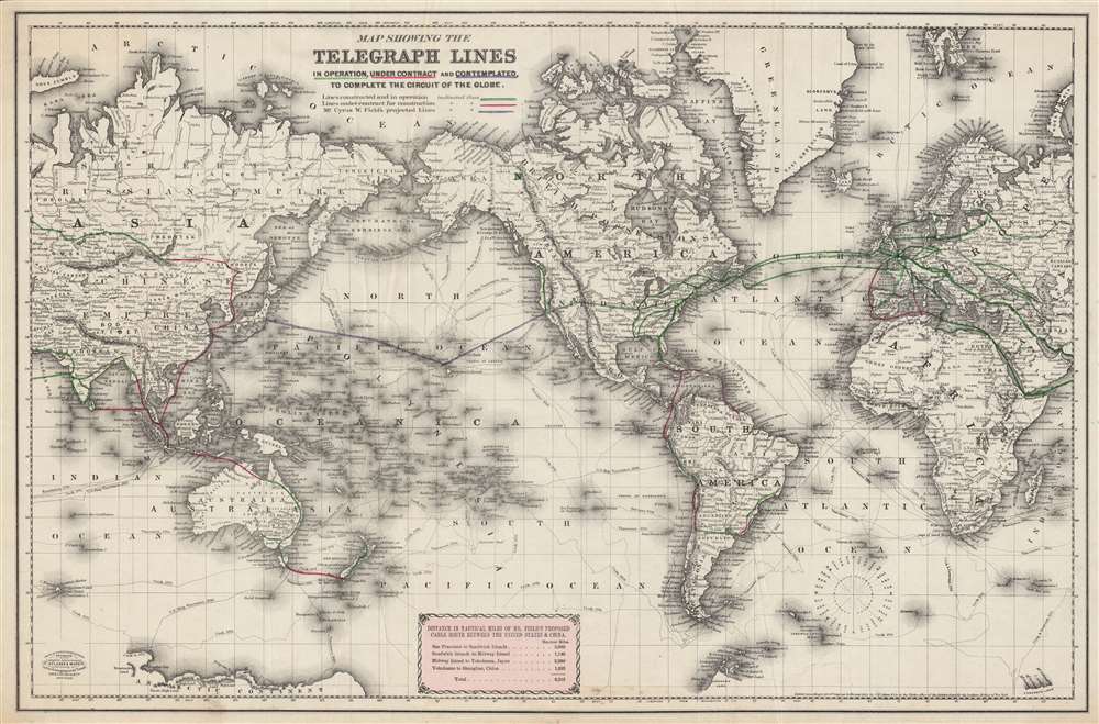
Map showing the telegraph lines in operation, under contract, and contemplated, to complete the circuit of the globe.
1871 (undated) 16.75 x 25.5 in (42.545 x 64.77 cm) 1 : 75000000
1871 (undated) 16.75 x 25.5 in (42.545 x 64.77 cm) 1 : 75000000
Description
This is an engaging c. 1871 map of existing and proposed global telegraph lines produced by G.W. and C.B. Colton. This map was produced in the wake of a speech to the U.S. Congress by Cyrus W. Field in May 1870 promoting a Transpacific cable. It highlights the promise of a complete global telegraph circuit, including across the Pacific Ocean, a project not completed until more than thirty years later.
Though completed in 1858, the first Transatlantic cable was plagued with problems and was barely usable, leading the architect of the project, Cyrus W. Field, to spend nearly a decade preparing a second, much improved, cable. By the time this map was produced, Transatlantic telegraphy was becoming faster and more reliable, leading Field and others to speculate on even more ambitious projects.
Ultimately, while the economic logic for a cable linking the Far East to the American West was not compelling, political logic drove the project. First the British and then the Americans were impelled to link their imperial possessions in the Pacific with the home country. For the British, this was less essential as Australia and New Zealand had telegraph links to Britain via Java, India, and the Suez beginning in the 1870s (nevertheless, Vancouver and Australia were connected via undersea cable in 1911). For the Americans, though, looking to secure and administer Hawaii, Guam, and the Philippines in the wake of the Spanish-American War, a cable across the Pacific was a necessity, and was completed in short order by the Commercial Pacific Cable Company, which had linked San Francisco with Shanghai by 1906.
A Closer Look
Existing international telegraph lines along with ones under construction and under consideration are displayed prominently on a global Mercator projection, with a corresponding table at bottom noting the distances. Small islands, which played an outsize role in the development of any telegraph lines, are emphasized. The travels of explorers in the Pacific (Perouse, Cook, Vancouver, etc.) are also tracked.Completing the Global Telegraph Circuit
Often forgotten in the wake of even more advanced communications technologies, telegraphy was nevertheless a revolutionary innovation that transformed economies and societies in the 19th century. Two major forces drove the development of international telegraph networks. One was the economic benefits of linking North America to Europe, and the other was the desire on the part of European powers (especially the British) to establish near-instantaneous communications throughout their empires. The importance of the latter objective became abundantly clear in the course of the Indian Mutiny of 1857.Though completed in 1858, the first Transatlantic cable was plagued with problems and was barely usable, leading the architect of the project, Cyrus W. Field, to spend nearly a decade preparing a second, much improved, cable. By the time this map was produced, Transatlantic telegraphy was becoming faster and more reliable, leading Field and others to speculate on even more ambitious projects.
A Proposed Transpacific Cable
In May 1870, Field gave a speech to the U.S. Congress where he proposed a cable across the Pacific similar to the Transatlantic cable. However, this was a much more difficult task, and one lacking the same economic imperative of the Transatlantic cable. Aside from Field's proposal for a submarine cable, an overland cable through Siberia and Alaska was also attempted, with backing from Western Union, but proved impossible to realize given the remote, rugged terrain and frigid temperatures involved.Ultimately, while the economic logic for a cable linking the Far East to the American West was not compelling, political logic drove the project. First the British and then the Americans were impelled to link their imperial possessions in the Pacific with the home country. For the British, this was less essential as Australia and New Zealand had telegraph links to Britain via Java, India, and the Suez beginning in the 1870s (nevertheless, Vancouver and Australia were connected via undersea cable in 1911). For the Americans, though, looking to secure and administer Hawaii, Guam, and the Philippines in the wake of the Spanish-American War, a cable across the Pacific was a necessity, and was completed in short order by the Commercial Pacific Cable Company, which had linked San Francisco with Shanghai by 1906.
Publication History and Census
Though copyrighted as 1855, this map is cataloged as c. 1871 by the Library of Congress and the Norman B. Leventhal Map and Education Center. Such a date is reasonable as it includes the Pacific cable proposed in 1870 by Cyrus W. Field, suggesting that an existing Colton world map from 1855 was updated to include the latest information. Aside from the institutions just mentioned, the map looks to be held by around six libraries and research institutions, though an exact census is difficult as the OCLC listing co-mingles digital and physical maps while also apparently listing some individual physical examples twice.Cartographer
Joseph Hutchins Colton (July 5, 1800 - July 29, 1893), often publishing as J. H. Colton, was an important American map and atlas publisher active from 1833 to 1897. Colton's firm arose from humble beginnings when he moved to New York in 1831 and befriended the established engraver, Samuel Stiles. He worked under Stiles as the 'Co.' in Stiles and Co. from 1833 to 1836. Colton quickly recognized an emerging market in railroad maps and immigrant guides. Not a cartographer or engraver himself, Colton's initial business practice mostly involved purchasing the copyrights of other cartographers, most notably David H. Burr, and reissuing them with updated engraving and border work. His first maps, produced in 1833, were based on earlier Burr maps and depicted New York State and New York City. Between 1833 and 1855, Colton proceeded to publish a large corpus of guidebooks and railroad maps, which proved popular. In the early 1850s, Colton brought his two sons, George Woolworth Colton (1827 - 1901) and Charles B. Colton (1832 - 1916), into the map business. G. W. Colton, trained as a cartographer and engraver, was particularly inspired by the idea of creating a large and detailed world atlas to compete with established European firms for the U.S. market. In 1855, G.W. Colton issued volume one of the impressive two-volume Colton's Atlas of the World. Volume two followed a year later. Possibly because of the expense of purchasing a two-volume atlas set, the sales of the Atlas of the World did not meet Colton's expectations, and so, in 1856, the firm also issued the atlas as a single volume. The maps contained in this superb work were all original engravings, and most bear an 1855 copyright. All of the maps were surrounded by an attractive spiral motif border that would become a hallmark of Colton's atlas maps well into the 1880s. In 1857, the slightly smaller Colton's General Atlas replaced the Atlas of the World. Most early editions of the General Atlas published from 1857 to 1859 do not have the trademark Colton spiral border, which was removed to allow the maps to fit into a smaller format volume. Their customers must have missed the border because it was reinstated in 1860 and remained in all subsequent publications of the atlas. There were also darker times ahead; in 1858, Colton was commissioned at a sum of 25,000 USD by the government of Bolivia to produce and deliver 10,000 copies of a large format map of that country. Although Colton completed the contract in good faith, delivering the maps at his own expense, he was never paid by Bolivia, which was at the time in the midst of a series of national revolutions. Colton would spend the remainder of his days fighting with the Bolivian and Peruvian governments over this payment, and in the end, after a congressional intervention, he received as much as 100,000 USD in compensation. Nonetheless, at the time, it was a disastrous blow. J. H. Colton and Company is listed as one of New York's failed companies in the postal record of 1859. This led Colton into the arms of Alvin Jewett Johnson and Ross C. Browning. The 1859 edition of Colton's General Atlas lists Johnson and Browning as the 'Successor's to J. H. Colton' suggesting an outright buyout, but given that both companies continued to publish separately, the reality is likely more complex. Whatever the case may have been, this arrangement gave Johnson and Browning access to many of Colton's map plates and gave birth to Johnson's New Illustrated (Steel Plate) Family Atlas. The Johnson's Atlas was published parallel to Colton's atlases well into the 1880s. The Colton firm itself subsequently published several other atlases including an Atlas of America, the Illustrated Cabinet Atlas, the Octavo Atlas of the Union, and Colton's Quarto Atlas of the World. They also published a large corpus of wall maps, pocket maps, and guides. The last known publications of the Colton firm date to 1897 and include a map and a view, both issued in association with the Merchant's Association of New York. Alice M. Colton married August R. Ohman (May 3, 1859 - April 22, 1934) on January 5, 1897. In 1898, Ohman joined the Colton firm, which continued to publish as Colton, Ohman & Co. until 1901. More by this mapmaker...
Condition
Very good. Slight wear on old fold lines.
References
OCLC 13395113.