1878 Hayden Geological Map of Bear Lake, Utah and Environs
WWyomingSEIdahoNEUtah-hayden-1878$400.00


Title
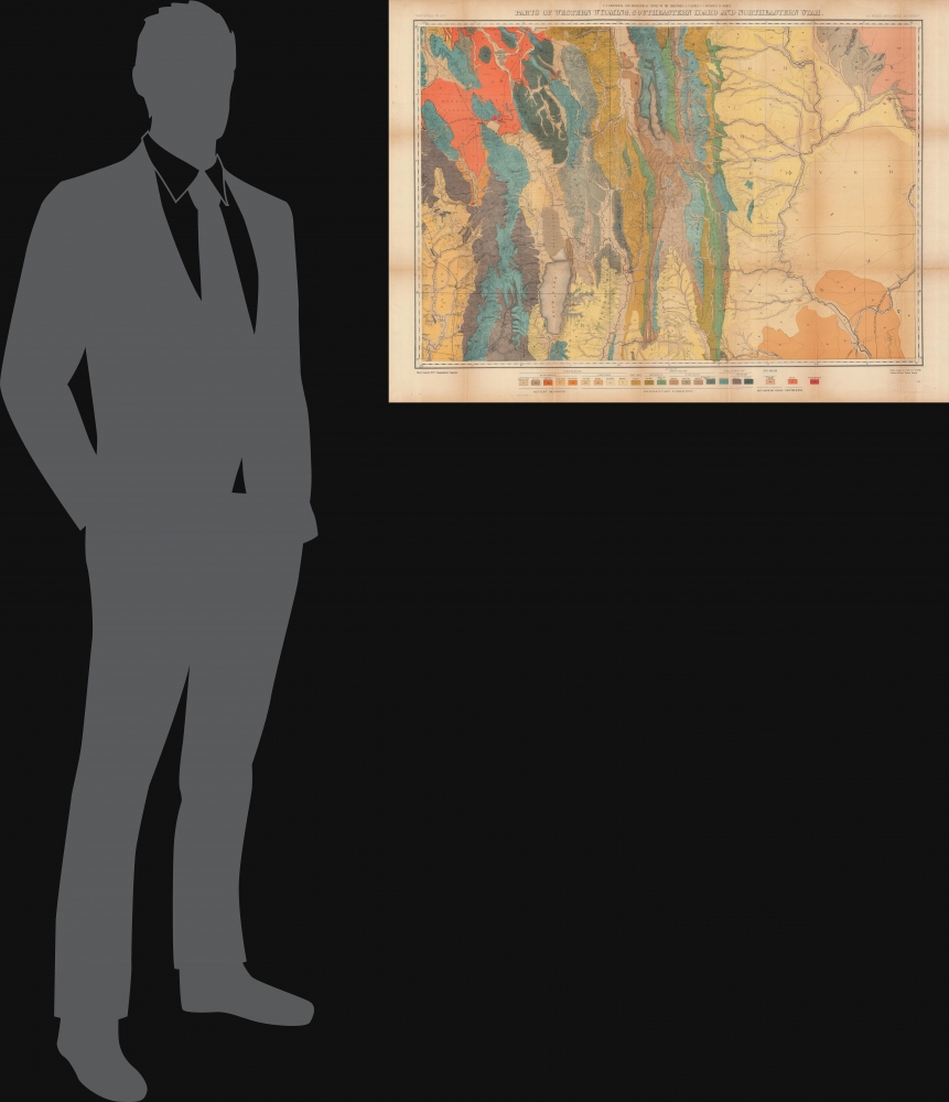
Parts of western Wyoming, southeastern Idaho and northeastern Utah.
1878 (dated) 25.5 x 34 in (64.77 x 86.36 cm) 1 : 253440
1878 (dated) 25.5 x 34 in (64.77 x 86.36 cm) 1 : 253440
Description
A brightly-colored 1878 geological map of the region around Bear Lake, on the border between Idaho, Utah, and Wyoming. It was produced by Albert Charles Peale and Henry Gannett for the U.S. Geological and Geographical Survey of the Territories (USGGST), the forerunner to the U.S. Geological Survey.
The work conducted by the survey that year played a critical role in convincing the U.S. Senate to create Yellowstone, the first U.S. National Park. The Survey worked in Colorado from 1873 through 1876 because of hostilities between white settlers and Native Americans in Wyoming. The team returned to Yellowstone in 1877 and 1878. Then, in 1879, the Hayden Survey, along with surveys led by John Wesley Powell (the Colorado River and the Grand Canyon) and Clarence King (Fortieth Parallel Survey), were merged to create the U.S. Geological Survey.
A Closer Look
The peaks of several mountain ranges and corresponding river valleys (especially the Bear, Salt, and Green Rivers) dominate the map. Brilliant colors represent different strata and types of rock, giving the map its impressive appearance. Elevations are represented by hachure, with heights of peaks noted. Rivers, creeks, lakes, roads, settlements, and other features such as hot springs are indicated. A road follows along western side of Bear Lake, with a string of towns along it, including Paris and Bloomington, while the Utah and Northern Railway (the first railroad to reach Idaho and Montana) runs parallel further to the west, on the other side of the Bear River Range.Mormon Content
This area's history in the preceding years was closely related to the Church of Jesus Christ of Latter-Day Saints. Morristown towards top-left was founded in 1863 by remnant members of the Church of the Firstborn (also known as Morrisites), a Mormon-inspired offshoot religion whose leader, Joseph Morris, was killed in a skirmish with the Utah militia in 1862. Soon afterwards, Soda Springs was founded nearby and made the seat of Oneida County, eclipsing Morristown by attracting Mormons from further south, including Brigham Young, who built a summer home there. The site of Morristown, meanwhile, dwindled and ended up under water when the Alexander Reservoir was created by the construction of the Alexander Dam (or Soda Dam) in 1925.The U.S. Geological and Geographical Survey of the Territories
The U.S. Geological and Geographical Survey of the Territories (also known as the Hayden Survey) was created under the U.S. Department of the Interior in 1870, with Ferdinand Vandeveer Hayden as its director. It operated through 1879. The first year the Survey operated in Wyoming on a budget of $25,000 with twelve assistants and eight teamsters and cooks. The following year (1871), the Survey received $40,000 and employed thirty-two individuals, including artist Thomas Moran and photographer W. H. Jackson. That year they launched from Ogden, Utah (which the Union Pacific Railroad had reached) and spent the summer in what is now Yellowstone National Park.The work conducted by the survey that year played a critical role in convincing the U.S. Senate to create Yellowstone, the first U.S. National Park. The Survey worked in Colorado from 1873 through 1876 because of hostilities between white settlers and Native Americans in Wyoming. The team returned to Yellowstone in 1877 and 1878. Then, in 1879, the Hayden Survey, along with surveys led by John Wesley Powell (the Colorado River and the Grand Canyon) and Clarence King (Fortieth Parallel Survey), were merged to create the U.S. Geological Survey.
Publication History and Census
This map was prepared by Albert Charles Peale and Henry Gannett, and produced by the USGGST. Though surveyed in 1877, the map is usually dated to 1878 as it appeared in the Twelfth Annual Report of the USGGST for the year 1878 (it is also sometimes dated to 1883 as the 1878 report was not published by the Government Printing Office until 1883). Moreover, there are two printings of the map, with the other being uncolored and lacking the information on rock formations at bottom. Due to these discrepancies over publication date, as well as cataloging variations in the title and attribution of authorship, and the co-mingling of digital and physical copies, it appears in multiple listings in the OCLC. Whether independently cataloged or as part of the full Twelfth Annual Report, the map is well represented in institutional collections.CartographerS
Ferdinand Vandeveer Hayden (September 7, 1829 - December 22, 1887) was an American geologist remembered for leading late 19th century pioneering surveying expedition in the Rocky Mountains and served as a doctor in the Union Army during the U.S. Civil War. Born in Westfield, Massachusetts, and discovered a fascination with nature and wildlife in his youth. He studied at Oberlin College and graduated in 1850, then attended the Albany Medical College and earned his degree in 1853. While at Albany, Hayden garnered the attention of Professor James Hall, then the state geologist of New York. Professor Hall convinced Hayden to join an expedition to the Nebraska Territory, where he collected fossils and studied geology. He accompanied expeditions led by Gouverneur K. Warren in 1856 and 1857 and the Raynolds Expedition of 1860 led by Captain William F. Raynolds. He served as an army surgeon during the U.S. Civil War and rose to become the chief medical officer of the Army of the Shenandoah. After the war, Hayden resumed working on geologic and geographic surveys in the Nebraska and Western Territories and was appointed geologist-in-chief of the United States Geological and Geographical Survey of the Territories in 1867. Hayden led the first federally funded geological survey into the Yellowstone Region in northwestern Wyoming in 1871 under orders from Secretary of the Interior Columbus Delano. The expedition included fifty men, including painter Thomas Moran and Civil War photographer William Henry Jackson. Hayden's report on the expedition, Preliminary Report of the United State Geological Survey of Montana and Portions of Adjacent Territories; Being a Fifth Annual Report of Progress played an instrumental role in persuading Congress to establish Yellowstone as the first U.S. National Park. More by this mapmaker...
Henry Gannett (August 24, 1846 - November 5, 1914) was an American geographer who is described as the 'Father of American topographic map making'. Born in Bath, Maine, Gannett entered Harvard at the age of twenty and received a bachelor's degree in 1869. He earned the degree of mining engineer from the Hooper Mining School in 1870. He joined the Hayden Survey in 1871, at the age of twenty-one, and continued worked for its successor, the U.S. Geological Survey until his death. Gannett was among those lobbying to centralize all government mapmaking under one agency. Before the creation of the United States Geological Survey, individual mapmakers and agencies had to compete for money from Congress to fund projects. He became chief geographer of the U.S. Geological Survey, a position he held for fifteen years. Most of the Survey's map-making methods developed during his tenure as chief geographer. Gannett also earned a reputation as an indefatigable compiler of geographic materials. His first job with the USGS was geographer of the 1880 United States Census. The completion of the census in 1882 is considered the start of true topographical work in the United States and the birth of the quadrangle. Gannet served as chief geographer on two subsequent censuses, 1890 and 1900, and was one of the founding members of the National Geographic Society. Gannett was also one of the founders of the Association of American Geographers and the Geological Society of America. Gannet organized the Board of Geographic Names, which became a permanent part of the federal government and considers geographic names in official use. Gannett served as chairman of this Board from 1894. Upon his death, the Annals of the Association of American Geographers lamented, 'in the death of Henry Gannett American Science has lost one of the pioneers who had an important share in the development of geography in this country into an organized science'. Gannett married Mary E. Chase in 1874 with whom he had two daughters and a son. Learn More...
Albert Charles Peale (April 1, 1849 - December 5, 1914) was a geologist, mineralogist, and member of the U.S. Geological and Geographical Survey of the Territories (also known as the Hayden Survey). He studied at Philadelphia's Central High School and trained to become a physician, earning a medical degree though never practicing medicine. In 1871, he joined Hayden and would spend most of the next thirty years with the Survey of the Territories and its successor, the U.S. Geological Survey. He later worked as a paleobotanist at the Smithsonian. Several natural features in Wyoming, Idaho, and Utah are named for him. Learn More...
Source
Hayden, F. V., Twelfth Annual Report of the United States Geological and Geographical Survey of the Territories: A report of progress of the exploration in Wyoming and Idaho for the year 1878, (Washington, D.C.: Government Printing Office) 1883.
Condition
Very good. Wear and toning along fold lines.
References
Rumsey 5945.000. OCLC 1060558576.