1878 Hayden Geological Map of Green River, Snake River, and Jackson Lake Region
WYIDUTGeological-hayden-1878$400.00


Title
Geological map of portions of Wyoming, Idaho and Utah.
1878 (dated) 20.5 x 36.5 in (52.07 x 92.71 cm) 1 : 506880
1878 (dated) 20.5 x 36.5 in (52.07 x 92.71 cm) 1 : 506880
Description
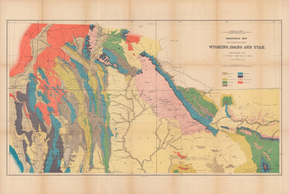
A colorful 1878 geological map of the border region between Wyoming, Idaho, and Utah produced by the U.S. Geological and Geographical Survey of the Territories (USGGST). It was one of several such maps to appear in the Twelfth Annual Report of the USGGST, representing the first detailed geological surveys undertaken in this portion of the American West.
The work conducted by the survey that year played a critical role in convincing the U.S. Senate to create Yellowstone, the first U.S. National Park. The Survey worked in Colorado from 1873 through 1876 because of hostilities between white settlers and Native Americans in Wyoming. The team returned to Yellowstone in 1877 and 1878. Then, in 1879, the Hayden Survey, along with surveys led by John Wesley Powell (the Colorado River and the Grand Canyon) and Clarence King (Fortieth Parallel Survey), were merged to create the U.S. Geological Survey.
A Closer Look
Coverage extends from the Snake River and Utah and Northern Railroad at left to the Seminoe and Rattle Snake Mountains at right, and north from the Jackson Lake region (including 'Jackson's Hole') south to Bear Lake and environs. The geological era and types of rock are indicated by bright colors, while mountains, rivers, lakes, stagecoach roads, railroads, Indian Reservations, and settlements are noted in detail.The U.S. Geological and Geographical Survey of the Territories
The USGGST (also known as the Hayden Survey) was created under the U.S. Department of the Interior in 1870, with Ferdinand Vandeveer Hayden as its director. It operated through 1879. The first year the Survey operated in Wyoming on a budget of $25,000 with twelve assistants and eight teamsters and cooks. The following year (1871), the Survey received $40,000 and employed thirty-two individuals, including artist Thomas Moran and photographer W. H. Jackson. That year they launched from Ogden, Utah (which the Union Pacific Railroad had reached) and spent the summer in what is now Yellowstone National Park.The work conducted by the survey that year played a critical role in convincing the U.S. Senate to create Yellowstone, the first U.S. National Park. The Survey worked in Colorado from 1873 through 1876 because of hostilities between white settlers and Native Americans in Wyoming. The team returned to Yellowstone in 1877 and 1878. Then, in 1879, the Hayden Survey, along with surveys led by John Wesley Powell (the Colorado River and the Grand Canyon) and Clarence King (Fortieth Parallel Survey), were merged to create the U.S. Geological Survey.
Publication History and Census
This map was prepared by Albert Charles Peale, Orestes St. John, and Frederick Miller Endlich, and produced by the USGGST. Though surveyed in 1877, the map is usually dated to 1878 as it appeared in the Twelfth Annual Report of the USGGST for the year 1878 (it is also sometimes dated to 1883 as the 1878 report was not published by the Government Printing Office until 1883). It is independently cataloged by 23 institutions worldwide, while the entire Twelfth Annual Report is well represented in institutional collections.CartographerS
Ferdinand Vandeveer Hayden (September 7, 1829 - December 22, 1887) was an American geologist remembered for leading late 19th century pioneering surveying expedition in the Rocky Mountains and served as a doctor in the Union Army during the U.S. Civil War. Born in Westfield, Massachusetts, and discovered a fascination with nature and wildlife in his youth. He studied at Oberlin College and graduated in 1850, then attended the Albany Medical College and earned his degree in 1853. While at Albany, Hayden garnered the attention of Professor James Hall, then the state geologist of New York. Professor Hall convinced Hayden to join an expedition to the Nebraska Territory, where he collected fossils and studied geology. He accompanied expeditions led by Gouverneur K. Warren in 1856 and 1857 and the Raynolds Expedition of 1860 led by Captain William F. Raynolds. He served as an army surgeon during the U.S. Civil War and rose to become the chief medical officer of the Army of the Shenandoah. After the war, Hayden resumed working on geologic and geographic surveys in the Nebraska and Western Territories and was appointed geologist-in-chief of the United States Geological and Geographical Survey of the Territories in 1867. Hayden led the first federally funded geological survey into the Yellowstone Region in northwestern Wyoming in 1871 under orders from Secretary of the Interior Columbus Delano. The expedition included fifty men, including painter Thomas Moran and Civil War photographer William Henry Jackson. Hayden's report on the expedition, Preliminary Report of the United State Geological Survey of Montana and Portions of Adjacent Territories; Being a Fifth Annual Report of Progress played an instrumental role in persuading Congress to establish Yellowstone as the first U.S. National Park. More by this mapmaker...
Frederick Miller Endlich (June 14, 1851 - July 17, 1899) was a mineralogist, chemist, and mining engineer. Born in Germany, he received a doctorate from the Universität Tübingen and emigrated to the United States of America. From 1872 to 1880, he worked at the Smithsonian Institution and participated in the U.S. Geological and Geographical Survey of the Territories. Afterwards, he served as a mining engineer consultant throughout the American West. Learn More...
Albert Charles Peale (April 1, 1849 - December 5, 1914) was a geologist, mineralogist, and member of the U.S. Geological and Geographical Survey of the Territories (also known as the Hayden Survey). He studied at Philadelphia's Central High School and trained to become a physician, earning a medical degree though never practicing medicine. In 1871, he joined Hayden and would spend most of the next thirty years with the Survey of the Territories and its successor, the U.S. Geological Survey. He later worked as a paleobotanist at the Smithsonian. Several natural features in Wyoming, Idaho, and Utah are named for him. Learn More...
Orestes Hawley St. John (1841 - 1921) was a geologist notable for his work with the U.S. Geological and Geographical Survey of the Territories (also known as the Hayden Expedition). He began his career with the Geological Survey of Illinois, with which he was intermittently associated from the 1860s until 1883. He also served as the principal geologist for the Second Geological Survey of Iowa from 1862 to 1868. Given his extensive experience, he was chosen to join the Hayden Expedition and led parties that surveyed the Wind River Mountains, portions of the Gros Ventre Range, the Wyoming Range, and the Snake River Valley. Learn More...
Julius (Julien) Bien (September 27, 1826 - December 21, 1909) was a German-Jewish lithographer and engraver based in New York City. Bien was born in Naumburg, Germany. He was educated at the Academy of Fine Arts, Cassell and at Städel's Institute, Frankfurt-am-Main. Following the suppression of the anti-autocratic German Revolutions of 1848, Bien, who participated in the pan-German movement, found himself out of favor in his home country and joined the mass German immigration to the United States. Bien can be found in New York as early as 1849. He established the New York Lithographing, Engraving & Printing Company in New York that focused on the emergent chromo-lithograph process - a method of printing color using lithographic plates. His work drew the attention of the U.S. Government Printing Office which contracted him to produce countless government maps and surveys, including the Pacific Railroad Surveys, the census, numerous coast surveys, and various maps relating to the American Civil War. Bien also issued several atlases both privately and in conjunction with a relation, Joseph Bien. At the height of his career Bien was elected president of the American Lithographers Association. After his death in 1909, Bien's firm was taken over by his son who promptly ran it into insolvency. The firm was sold to Sheldon Franklin, who, as part of the deal, retained the right to publish under the Julius Bien imprint. In addition to his work as a printer, Bien was active in the New York German Jewish community. He was director of the New York Hebrew Technical Institute, the New York Hebrew Orphan Asylum, and president of the B'nai B'rith Order. Learn More...
Source
Hayden, F. V., Twelfth Annual Report of the United States Geological and Geographical Survey of the Territories: A report of progress of the exploration in Wyoming and Idaho for the year 1878, (Washington, D.C.: Government Printing Office) 1883.
Condition
Very good. Wear and toning along fold lines. Verso repairs to one fold intersection.
References
Rumsey 5948.000. OCLC 27658853, 953570022.