1908 General Land Office Map of Yellowstone National Park
Yellowstone-berthrong-1908$950.00

Title
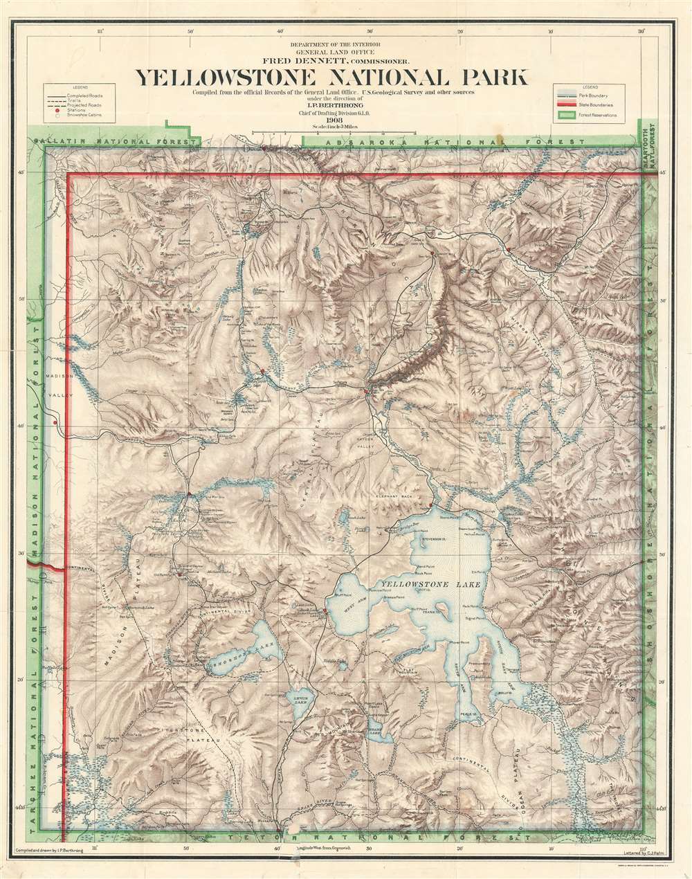
Yellowstone National Park Compiled from the official Records of the General Land Office, U.S. Geological Survey and other sources under the direction of I.P. Berhrong Chief of Drafting Division G. L. O. 1908.
1908 (dated) 25.5 x 20.25 in (64.77 x 51.435 cm) 1 : 190080
1908 (dated) 25.5 x 20.25 in (64.77 x 51.435 cm) 1 : 190080
Description
This is a 1908 General Land Office map of Yellowstone National Park, compiled and drawn by Ithamar Berthrong, who produced many important maps of the west during his tenure with the Land Office. This attractively-colored map of the Park is richly detailed, showing the vigorous topography of the area with fine shading. Sites of geysers and other important and popular features are indicated, but the emphasis on the map is on its use, and on projects under way to make it accessible to visitors. Ranger stations are shown, as is the recently-constructed Old Faithful Lodge (marked but not named. Trails and roads through the park are delineated, as are planned, improved roads. The process of improving the park for visitors had only begun in 1903, and the ongoing project is plainly visible here.
Publication History and Census
The map appears to have first been published by the General Land Office in 1907; we are aware of further editions in 1908, 1909, 1910, and 1911. OCLC shows perhaps two dozen examples all told in institutional collections, of which four are this 1908 issue. The map appears to be scarce on the market, with only a few appearing in catalogue or auction listings in the past thirty years.CartographerS
Ithamar Parsons Berthrong (February 26, 1853 - July 29, 1936) was an American surveyor, inventor, and draftsman active with the General Land Office of the U.S. Department of the Interior. Berthrong was born in Rochester, New York. He was made chief of the drafting division on March 23 of 1907. He is associated with many of the most important early 20th century maps issued by the GLO, among them, important maps of Arizona, Colorado, Wyoming, Oregon, Washington, and more. More by this mapmaker...
The General Land Office (GLO) (1812 - 1946) was an independent agency of the United States government responsible for public domain lands in the United States. Created in 1812, it took over functions previously conducted by the Department of the Treasury. The GLO oversaw the surveying, platting, and sale of public lands in the western United States. It also administered the Preemption Act of 1841, which allowed individuals who were already living on federal land to purchase up to 160 acres of land before it was offered for sale to the general public, if they met certain requirements. Following the passage of the Homestead Act in 1862, which was also administered by the GLO, claims under the Preemption Act sharply decreased. The GLO became a part of the newly-created Department of the Interior in 1849. In 1891 Grover Cleveland and Congress created 17 forest reserves, due to public concern over forest conservation, which were initially managed by the GLO, until they were transferred to the Forest Service in 1905. In 1946 the Government Land Office was merged with the United States Grazing Service to become the Bureau of Land Management. Today the Bureau of Land Management administers the roughly 246 million acres of public land remaining under federal ownership. Learn More...
Condition
Good condition. Few mends at folds, marginal mends and some reinstatement of border.
References
Not in Rumsey. OCLC 367555018.