This item has been sold, but you can get on the Waitlist to be notified if another example becomes available, or purchase a digital scan.
1896 U.S. Geological Survey Geological Map of Yellowstone National Park (4 sheets)
YellowstoneGeo-usgs-1896$150.00

Title
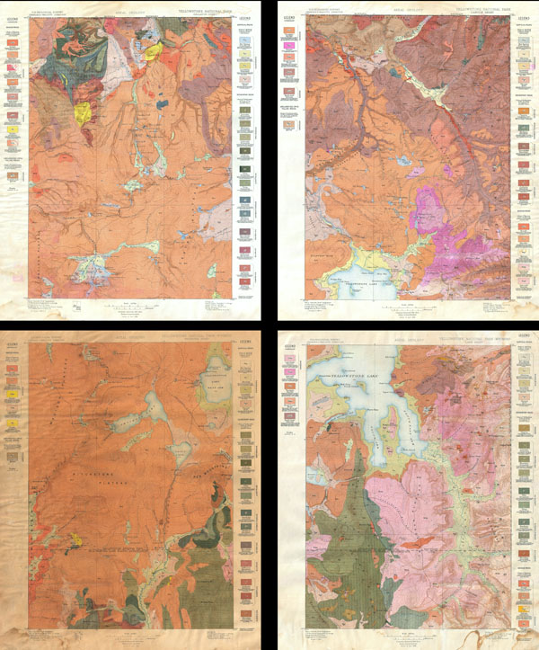
Yellowstone National Park, Gallatin Sheet. / Yellowstone National Park - Wyoming, Lake Sheet / Yellowstone National Park - Wyoming, Shoshone Sheet. / Yellowstone National Park, Canyon Sheet.
1896 (dated) 19.5 x 15 in (49.53 x 38.1 cm)
1896 (dated) 19.5 x 15 in (49.53 x 38.1 cm)
Description
This is the rare U.S. Geological Survey of Yellowstone National Park in four sheets. Depicts the entire park in considerable detail noting topography, hot springs, rivers and creeks, marshes, geysers, lakes and ponds. Also specifically notes the Continental Divide. Shaded to illustrate different types of rock and geological zones. Divided into four sheets: the Canyon Sheet, the Lake Sheet, the Gallatin Sheet and the Shoshone sheet. Published by the U.S. Geological survey based on surveys conducted between 1884 and 1885 under Henry Gannett, Chief Geographer and J. H. Renshawe, Geographer in charge of the expedition. The topography for this map is the work of Frank Tweedy, S. A. Aaplin Jr., J. H. Renshawe and W. H. Leffingwell. Triangulation was accomplished by H. S. Chase. This is the April 1896 edition. Each sheet measures 19.5 x 15 inches.
Cartographer
The Office of the Coast Survey (later the U.S. Geodetic Survey) (1807 - present), founded in 1807 by President Thomas Jefferson and Secretary of Commerce Albert Gallatin, is the oldest scientific organization in the U.S. Federal Government. Jefferson created the "Survey of the Coast," as it was then called, in response to a need for accurate navigational charts of the new nation's coasts and harbors. The first superintendent of the Coast Survey was Swiss immigrant and West Point mathematics professor Ferdinand Hassler. Under the direction of Hassler, from 1816 to 1843, the ideological and scientific foundations for the Coast Survey were established. Hassler, and the Coast Survey under him developed a reputation for uncompromising dedication to the principles of accuracy and excellence. Hassler lead the Coast Survey until his death in 1843, at which time Alexander Dallas Bache, a great-grandson of Benjamin Franklin, took the helm. Under the leadership A. D. Bache, the Coast Survey did most of its most important work. During his Superintendence, from 1843 to 1865, Bache was steadfast advocate of American science and navigation and in fact founded the American Academy of Sciences. Bache was succeeded by Benjamin Pierce who ran the Survey from 1867 to 1874. Pierce was in turn succeeded by Carlile Pollock Patterson who was Superintendent from 1874 to 1881. In 1878, under Patterson's superintendence, the U.S. Coast Survey was reorganized as the U.S. Coast and Geodetic Survey (C & GS or USGS) to accommodate topographic as well as nautical surveys. Today the Coast Survey is part of the National Oceanic and Atmospheric Administration or NOAA. More by this mapmaker...
Source
Walcott, Charles D., Geologic Atlas of the United States Yellowstone National Park Folio Wyoming. (1896 edition).
Condition
Average condition. At some point these appear to have been exposed to water. Minor water stains (visible in photo) affect corners and some water damage is apparent on verso. Shoshone sheet is significantly browned compared to other three sheets. Because of this we are offing a significant discount on what is otherwise a 500 USD set.