1904 U.S.G.S Topographic Map of Travertine Terraces, Yellowstone National Park
YellowstoneMammothTravertineT-usgs-1904-2$250.00

Title
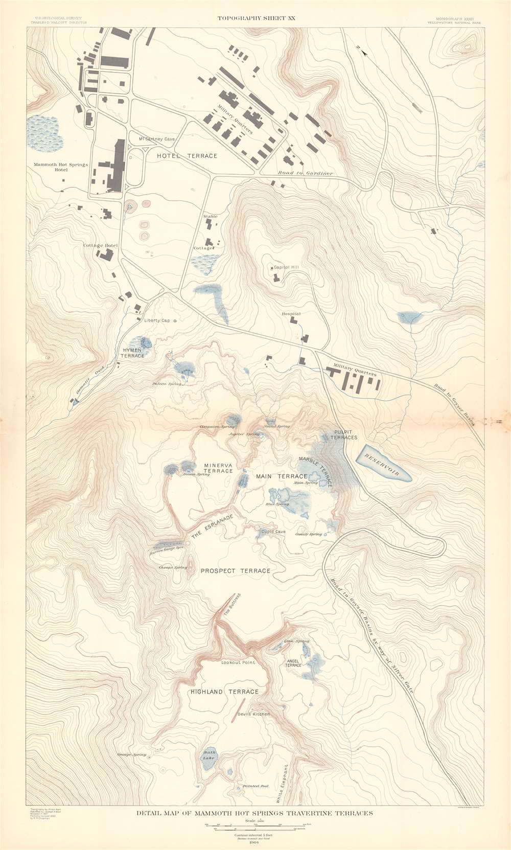
Detail Map of Mammoth Hot Springs Travertine Terraces. Topography Sheet XX.
1904 (dated) 34 x 19.5 in (86.36 x 49.53 cm) 1 : 2400
1904 (dated) 34 x 19.5 in (86.36 x 49.53 cm) 1 : 2400
Description
This is a 1904 Arnold Hague and U.S. Geological Survey topographic map of spectacular Mammoth Hot Springs Travertine Terraces of Yellowstone National Park, Wyoming. Centered on Cleopatra Spring in Minerva Terrace, the map depicts the Travertine Terraces from the Painted Pool on the White Elephant in Highland Terrace to McCartney Cave in Hotel Terrace. It also identifies Liberty Cap on Hymen Terrace. Contour lines highlight the region's unique topography with elevation noted every 500 feet. Roads and buildings are illustrated, including the Mammoth Hot Springs Hotel.
Yellowstone National Park
Yellowstone National Park, established by the U.S. Congress and signed into law by President Ulysses S. Grant on March 1, 1872, is America's first and most famous national park. The park occupies the northwestern corner of Wyoming but also includes parts of Montana and Idaho. Yellowstone is considered to be the world's first national park. Today a UNESCO World Heritage Site, the park is known for its incredible geothermal features, the most famous of which is the Old Faithful Geyser. Yellowstone's iconic geothermal activity is caused by a dormant supervolcano, the largest in North America, lying directly under the park. Yellowstone Lake, one of the largest high-elevation lakes on the continent, occupies the caldera's center. Yellowstone is also renowned for its wildlife, home to wolves, grizzly bear, elk, black bear, and America's largest wild bison herd. As one of the most popular National Parks in the United States, millions visit Yellowstone annually to experience its mud pots, geysers, wildlife, and striking scenery.Publication History and Census
This map was created under the supervision of Arnold Hague with geology by Walter Harvey Weed from survey data collected in 1889 by a team under the supervision of Frank Tweedy. It was published by the United States Geological Survey in 1904 and printed by Julius Bien. An example is part of the David Rumsey Map Collection, but it is not individually cataloged in OCLC. The atlas in which it was published is very well represented institutionally.CartographerS
The United States Geological Survey (1878 - Present), aka the U.S.G.S., is a scientific agency of the United States government, which was founded in 1879. USGS scientists study the landscape of the United States, its natural resources, and the natural hazards that threaten it. The organization has four major science disciplines: biology, geography, geology, and hydrology. It is a bureau of the United States Department of the Interior and is the department's only scientific agency. More by this mapmaker...
Arnold Hague (December 13, 1840 - May 14, 1917) was an American geologist and surveyor active in the late 18th and early 19th century. Hague was born in Boston, Massachusetts in 1840. As the son of a clergyman he was well educated and graduated from Yale University in 1863. Afterwards he traveled for Europe where he pursued further studies in geology at Gottingen, Heidelberg, and Freiberg. Upon his return to the United State in 1867 Hague was assigned to assist Clarence King in a study of the surface geology of the Comstock Lode and the amalgamation process, known as the ‘Washoe Process' practiced there. When the U.S. Geological Survey was formed in 1879 Hague became a founding member. In 1883 he was commissioned as the official geologist of Yellowstone National Park and assigned to study the parks famous geysers. Hague's report on Yellowstone, published in 1904, is perhaps his most significant work and certainly the work for which is best known today. Hague died in Washington D.C. in 1917. He was a member of the National Academy of Sciences, vice president of the International Congress of Geologists, and president of the United States Geological Society. Learn More...
Julius (Julien) Bien (September 27, 1826 - December 21, 1909) was a German-Jewish lithographer and engraver based in New York City. Bien was born in Naumburg, Germany. He was educated at the Academy of Fine Arts, Cassell and at Städel's Institute, Frankfurt-am-Main. Following the suppression of the anti-autocratic German Revolutions of 1848, Bien, who participated in the pan-German movement, found himself out of favor in his home country and joined the mass German immigration to the United States. Bien can be found in New York as early as 1849. He established the New York Lithographing, Engraving & Printing Company in New York that focused on the emergent chromo-lithograph process - a method of printing color using lithographic plates. His work drew the attention of the U.S. Government Printing Office which contracted him to produce countless government maps and surveys, including the Pacific Railroad Surveys, the census, numerous coast surveys, and various maps relating to the American Civil War. Bien also issued several atlases both privately and in conjunction with a relation, Joseph Bien. At the height of his career Bien was elected president of the American Lithographers Association. After his death in 1909, Bien's firm was taken over by his son who promptly ran it into insolvency. The firm was sold to Sheldon Franklin, who, as part of the deal, retained the right to publish under the Julius Bien imprint. In addition to his work as a printer, Bien was active in the New York German Jewish community. He was director of the New York Hebrew Technical Institute, the New York Hebrew Orphan Asylum, and president of the B'nai B'rith Order. Learn More...
Source
Hague, A., Atlas to Accompany Monograph XXXII on the Geology of the Yellowstone National Park, (Washington, USGS) 1904.
Condition
Good. Exhibits light soiling. Blank on verso.
References
Rumsey 4252.017. Philips P5115.