This item has been sold, but you can get on the Waitlist to be notified if another example becomes available, or purchase a digital scan.
1895 Fee Chromolithograph Bird's-Eye View Map of Yellowstone National Park
YellowstoneView-fee-1895$750.00

Title
Yellowstone National Park. Northern Pacific Railway.
1895 (dated) 24.25 x 18.25 in (61.595 x 46.355 cm)
1895 (dated) 24.25 x 18.25 in (61.595 x 46.355 cm)
Description
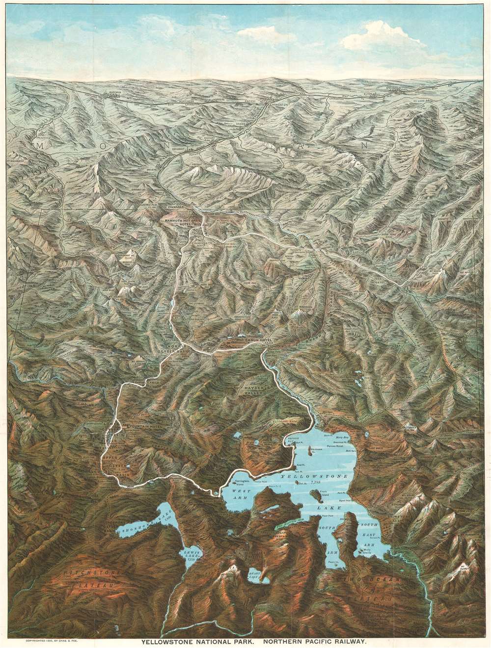
This is an 1895 Charles S. Fee chromolithograph bird's-eye view map of Yellowstone National Park, Wyoming. With Yellowstone Lake in the foreground, the view extends northward as far as Bozeman and Livingston, Montana. Fee includes impressive detail throughout, identifying mountains, plateaus, lakes, geyser basins, and hot springs. Yellowstone landmarks, such as Elephant Back, the Grand Canyon, and Old Faithful (in the Upper Geyser Basin), are labeled. The Lake Hotel, Fountain Hotel, Canon Hotel, and Mammoth Hot Springs Hotel all appear. The Yellowstone River snakes its way through the park and roads (colored white, so they stand out) wind their way from north to south. The Northern Pacific Railway runs across the top of the view and south from Livingston to Cinnabar, just outside Yellowstone.
Yellowstone National Park
Yellowstone National Park, established by the U.S. Congress and signed into law by President Ulysses S. Grant on March 1, 1872, is America's first and most famous national park. The park occupies the northwestern corner of Wyoming but also includes parts of Montana and Idaho. Yellowstone is considered to be the world's first national park. Today a UNESCO World Heritage Site, the park is known for its incredible geothermal features, the most famous of which is the Old Faithful Geyser. Yellowstone's iconic geothermal activity is caused by a dormant supervolcano, the largest in North America, lying directly under the park. Yellowstone Lake, one of the largest high-elevation lakes on the continent, occupies the caldera's center. Yellowstone is also renowned for its wildlife, home to wolves, grizzly bear, elk, black bear, and America's largest wild bison herd. As one of the most popular National Parks in the United States, millions visit Yellowstone annually to experience its mud pots, geysers, wildlife, and striking scenery.Chromolithography
Chromolithography is a color lithographic technique developed in the mid-19th century. The process involved using multiple lithographic stones, one for each color, to yield a rich composite effect. Oftentimes, the process would start with a black basecoat upon which subsequent colors were layered. Some chromolithographs used 30 or more separate lithographic stones to achieve the desired effect. Chromolithograph color could also be effectively blended for even more dramatic results. The process became extremely popular in the late 19th and early 20th centuries, when it emerged as the dominate method of color printing. The vivid color chromolithography produced made it exceptionally effective for advertising and propaganda imagery.Publication History and Census
This view-map was created by Charles S. Fee and published by the Northern Pacific Railroad in 1895. Six examples are cataloged in OCLC and are part of the institutional collections at Pennsylvania State University, the University of Missouri-St. Louis, the Colorado School of Mines, the Denver Public Library, the Montana Historical Society, and Stanford University. Scarce to the market.CartographerS
Charles Sumner Fee (September 24, 1853 - September 25, 1923) was an American railroad man active in the American Midwest and California during the latter part of the 19th and early 20th centuries. Fee was born in Laurel, Ohio. Fee began his railroad career in 1873 as general secretary to the manager of the Michigan Central Railway. In 1877 he took a position as H. E. Sargent's secretary at the Northern Pacific Railroad, which at the time had only about 400 miles of track. In 1883, he was promoted to Northern Pacific General Passenger Agent, a position he held until 1904, when he took over E. O. McCormic's position as passenger and traffic manager of the San Francisco office of the Southern Pacific Railroad. He was one of the directors of the 1915 Panama Pacific Exposition in San Francisco. Fee died in San Francisco in 1923, at the time he was still working at the Southern Pacific Railroad. More by this mapmaker...
Poole Brothers (1878 - 1968) were a Chicago based firm active in the late 19th and early 20th century with an initial focus on promotional railroad maps. Poole Brothers was founded by George Amos Poole (March 20, 1843 – September 7, 1918). In 1868, Poole, along with his uncle William H. Rand (1828 - 1915) and Andrew McNally (1836 - 1904), purchased the Chicago Tribune's job printing plant and formed the firm Rand McNally. In 1878, he left Rand McNally to form, with his brother William H. Poole, Poole Brothers, a direct competitor to Rand McNally for the lucrative railroad business. Like many of its competitors, Poole Brothers maintained an office on Chicago's Printer's Row (downtown Loop district). Their earliest known work is an 1880 map of Yellowstone National Park. In 1887, Poole Brothers, Andrew McNally, and several others formed the United Typothetae of America, a master printers association. In 1848, they were cited, along with Rand McNally and George Cram, by the Federal Trade Commission for price fixing. Their earliest known work is an 1880 map of Yellowstone National Park. Afterward they went on to produce a vast range of maps and other print products including tickets, cards, coupons, and restaurant menus. In time Poole Brothers merged with Newman-Randolph, which was then acquired by the American Can Company in the early 1960s. The American Can Company liquidated its printing concerns later in the same decade. Learn More...
Condition
Very good. Exhibits light wear along original fold lines. Verso repair to a fold separations along margin. Map of Pacific Northwest, text, and printed photographs on verso.
References
OCLC 51609632.