This item has been sold, but you can get on the Waitlist to be notified if another example becomes available, or purchase a digital scan.
1856 Chase and Smith Wall Map of York County, Maine
YorkCountyMaine-chasesmith-1856$1,250.00

Title
York County Maine.
1856 (dated) 58.5 x 58.5 in (148.59 x 148.59 cm) 1 : 61500
1856 (dated) 58.5 x 58.5 in (148.59 x 148.59 cm) 1 : 61500
Description
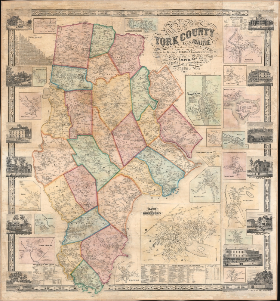
An impressive 1856 Josiah Chase Jr. wall map of York County, Maine.
A Closer Look
Coverage embraces York County, Maine's southernmost, with townships color-coded and individual homesteads identified. Twenty-one insets of York County towns include Kennebunk, Kennebunkport, Moderation, York, East Parsonfield, Saco and Biddeford, and Kittery. Thirteen views of residences and businesses are also included, among them the Alfred Court House; shipwrights at Kennebunkport; the residence of Joseph Titcomb in Kennebunk; the residence of Benjamin Dudley, Esq. in Kennebunkport; and the Saco Town House.Historical Context
In the late 19th century, York County was transforming through economic diversification and growth. The county began to shift from its traditional maritime and agricultural bases towards manufacturing and tourism. The development of railways facilitated this transition, connecting York County more effectively with larger markets and making it an accessible destination for tourists. The area's picturesque landscapes, including its rugged coastline and serene beaches, began to attract summer visitors, laying the foundation for today's summer resort economy. Meanwhile, textile mills and other manufacturing establishments started to appear, reflecting the broader industrialization of New England.Publication History and Census
This map was created by J. Chase Jr., published by J. L. Smith and Company, and copyrighted by Robert Pearsall Smith in 1856. Two examples are cataloged in OCLC: the Library of Congress and the University of Maine at Orono.Cartographer
Robert Pearsall Smith (February 1, 1827 - April 17, 1898) was an American map maker active in Philadelphia from the middle to late 19th century. Smith was born to a Quaker family in Philadelphia, all librarians and publishers. Robert Pearsall originally ran a law bookstore at 19 James Street, Philadelphia. It was not until 1846 that Smith began producing maps in collaboration with this father, John Jay Smith, and brother, Lloyd P. Smith. One year earlier, in 1845, John Jay, then librarian at the Library Company of Philadelphia and Loganian Library, acquired the American rights to the anastatic process of transfer lithography. In February of 1846 he and his two sons founded the Anastatic Office, a printing concern based on the anastatic process located at 317 Market Street, Philadelphia. The Anastatic Office produced numerous copies and reissues of historic documents and maps from the Library Company's collection before being dissolved in 1847. In the same year Robert Pearsall opened a printing establishment under his own name at 144 Chestnut Street. In 1858, he joined forced with the Swiss-American engraver Frederick Bourquin (1808 - 1897) under the imprint 'F. Bourquin and Company' (602 Chestnut Street). Smith retired suddenly and inexplicably from the printing business around 1865. Smith was also deeply religious, a lay leader in the Holiness Movement in the United States and the Higher Life Movement in Great Britain. Smith and his wife, Hannah Tatum Whitall, first crossed the Atlantic to preach in England, Germany and Switzerland in 1873. They returned in 1875, preaching in Brighton, where Smith supposedly had an affair with an American writer. In, 1888, his entire family moved to England. More by this mapmaker...
Condition
Very good. Full professional restoration.
References
OCLC 1039112630.