This item has been sold, but you can get on the Waitlist to be notified if another example becomes available, or purchase a digital scan.
1885 Yosemite Stage and Turnpike Company Map of Yosemite National Park, California
YosemiteNP-yosemitestageco-1885$225.00

Title
Yosemite Wawona Route via Mariposa Big Trees, Inspiration Point and Glacier Point.
1885 (undated) 20.75 x 26.5 in (52.705 x 67.31 cm) 1 : 316800
1885 (undated) 20.75 x 26.5 in (52.705 x 67.31 cm) 1 : 316800
Description
This is a c. 1885 Yosemite Stage and Turnpike Company map of Yosemite National Park, California.
A Closer Look
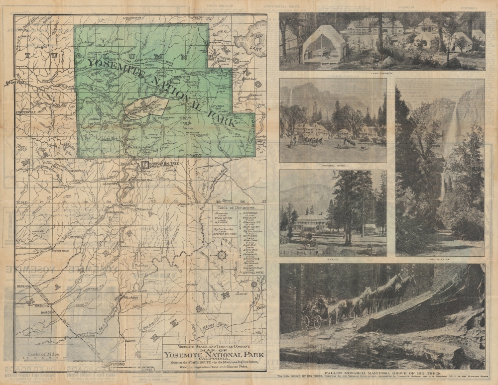
A bright green highlights Yosemite National Park. The original Yosemite Grant containing Yosemite Valley is encircled by a bold black line and not shaded green. The Sentinel Hotel, El Capitan, Inspiration Point, and Sentinel Dome are labeled within the original Grant. Peaks, rivers, valleys, and roads are illustrated throughout Yosemite. Wawona appears along the Yosemite Road on the park's southern border. The Mariposa Big Tree Grove is outlined just south of the park and the Yosemite Road is illustrated from Wawona south to Raymond (it also continues north from Wawona to Yosemite Valley). Rivers, towns, and roads in the surrounding region are illustrated as well, along with the Southern Pacific Railroad's lines. Fresno appears at bottom center. Printed photographs of Camp Yosemite, the Sentinel Hotel (with a stagecoach in front), Wawona, Yosemite Falls, and the Fallen Monarch in the Mariposa Grove of Big Trees occupy the right portion of the sheet.Verso Content
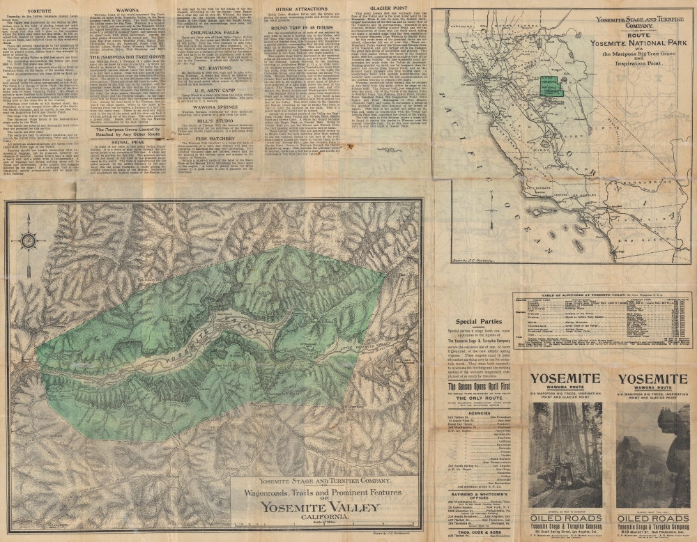
A map of the Yosemite Valley occupies over a quarter of the verso and illustrates wagon roads, trails, and other prominent features within the valley. A second map in the upper right depicts the state of California with the route to Yosemite National Park noted. Additional text provides proposed itineraries and activities.The Yosemite Stage and Turnpike Company
The Yosemite Stage and Turnpike Company was founded in 1876 by the Washburn brothers, who had recently moved to California from Vermont. They founded a hotel in the Yosemite Valley, now known as the Wawona Hotel complex. By 1879, the enterprise was so successful that the company built a toll road with stage service to the Yosemite Valley. The service initially ran from the South Pacific stop at Madera, but after a wet winter when their stagecoaches were mired in the mud, the Washburns convinced the Southern Pacific to build a spur line to Raymond. From Raymond, the stagecoaches took visitors to the Mariposa Big Trees Grove, as well as Inspiration Point (which the map states is the point from which all the famous paintings of Yosemite had been composed), and Glacier Point.Publication History and Census
This map was drawn by Julius C. Henkenius and published by Britton and Rey c. 1885. We have located catalog entries for a half dozen or so examples of a map bearing the same title, but those examples are cataloged as being published by Sunset Press, not Britton and Rey, suggesting that these are later editions.CartographerS
Julius Charles Henkenius (1843 - March 6, 1909) was a German American draftsman and civil engineer. Born in Germany, Henkenius was naturalized on April 19, 1882. He worked as the chief draftsman in the United States Survey office in San Francisco at the time of his death and had worked for the Office of the United States Surveyors-General since at least 1881. He had lived in Alameda, California, from at least 1889. He died of heart failure. More by this mapmaker...
Britton and Rey (1852 - 1906) was a lithographic firm based in San Francisco founded by Joseph Britton (1825 - 1901) and Jacques Joseph Rey (1820 - 1892). The leading firm in the area during the second half of the 19th century, Britton and Rey eventually earned the reputation of being the western Currier and Ives. They published both large-format and postcard views of California, as well as with stock certificates, stationery, and maps. Within the partnership, Rey was the artist and Britton the principal lithographer. Britton was also principally concerned with the business aspects of the firm. The firm also printed lithographs by other artists, including Thomas Almond Ayres (1816 - 1858), George Holbrook Baker (1824 - 1906), Charles Christian Nahl (1818 - 1878), and Frederick August Wenderoth (1819 - 1884). After Rey's death in 1892 and Britton's subsequent retirement, the firm passed to Rey's son, Valentine J. A. Rey, who ran the firm until at least the 1906 San Francisco earthquake and fire. A. Carlisle and Company, another San Francisco printer, acquired the remains of the Britton and Rey firm in 1916. For more information about Joseph Britton and Jacques Joseph Rey, please reference their individual biographies included in our cartographer database. Learn More...
Condition
Good. Wear along original fold lines. Verso repairs to fold separations and at fold intersections. Small areas of loss at some fold intersections. Text, Map of Yosemite Valley and Map of the Route to Yosemite National Park on verso.