
This item below is out of stock, but another example (left) is available. To view the available item, click "Details."
Details
1561 / 1564 Ruscelli Edition of Nicolo Zeno's Map of the North Atlantic
$1,400.00
1561 / 1562 Ruscelli Edition of Nicolo Zeno's Map of the North Atlantic
Zeno-ruscelli-1561-2$800.00

Title
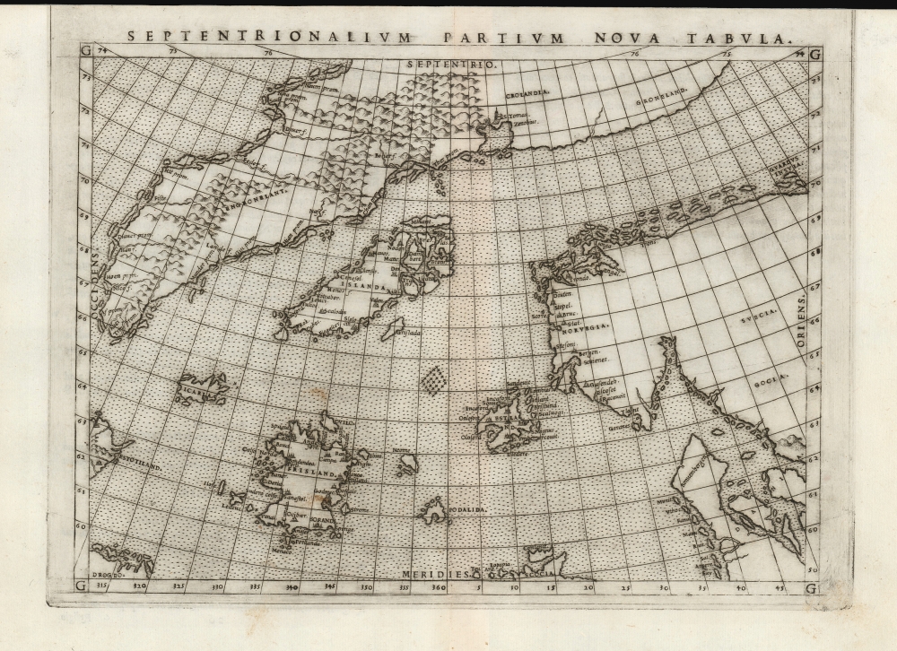
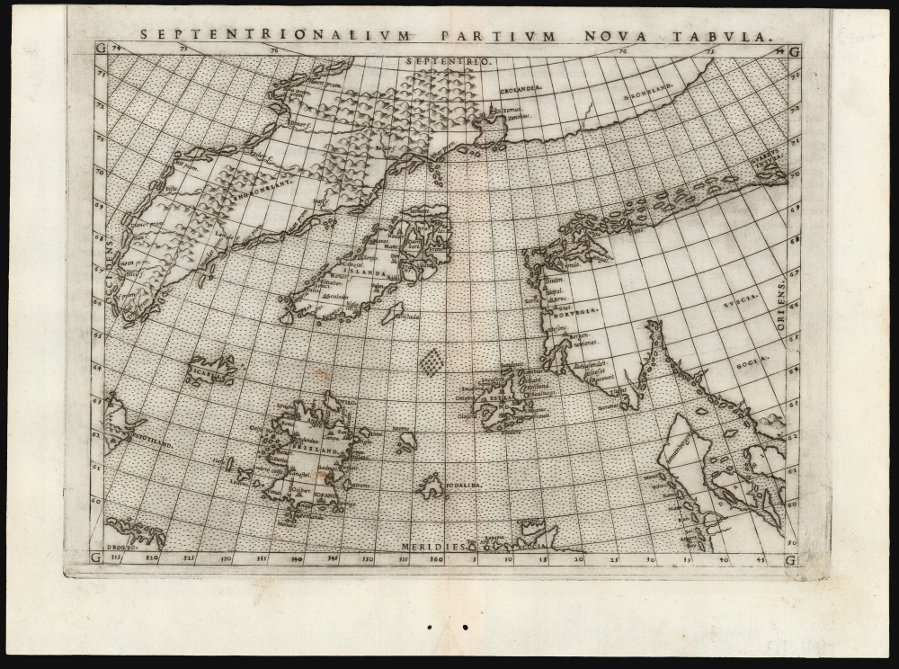
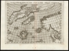
Septentrionalium Partium Nova Tabula.
1561 (undated) 7.5 x 9.5 in (19.05 x 24.13 cm) 1 : 11000000
1561 (undated) 7.5 x 9.5 in (19.05 x 24.13 cm) 1 : 11000000
Description
This is the most important map of Girolamo Ruscelli's 1561 - 1562 edition Ptolemy: the earliest acquirable iteration of Nicoló Zeno's 1558 Carta Da Navegar De Nicolo et Antonio Zeni Furono In Tramontana Lano MCCCLXXX, revealing the alleged 14th-century voyages of Zeno's ancestors, Nicoló and Antonio. Zeno's fraud, intended to enhance his political power in Venice and later embraced as to co-opt the 1492 Columbia discovery of America, was responsible for the initial appearance and subsequent tenacity of the apocryphal islands Frisland, Icaria, Drogeo, and the coastline of Estotiland, which was taken by some of Europe's finest geographers to be the coast of Labrador.
Iceland appears just left of center: its eastern coast broken into an archipelago, in a misinterpretation of the ice floes indicated on the Olaus Magnus Carta Marina and a clue to one of the mapmaker's sources. The waters between Iceland and Scotland are populated by the imaginary islands of Icaria, Estland, and Frisland (whose cities are depicted in greater detail even than Iceland). In its western extremes, the map shows the coastlines of Estotiland and Drogeo. These were interpreted to indicate Labrador and Newfoundland, respectively, and their appearance here is likely to have been of the greatest importance to the 16th-century Zeno, above and beyond the spurious islands commanding the center of the map. Frisland, Icaria, Estotiland, Deogeo, and many other locales on the map - including a monastery in Greenland that benefited from hot springs - appeared first on the 1558 production.
Zeno's Success
Although eventually exposed as a deliberate fraud, Zeno's deception was widely accepted as genuine - thanks largely to Ruscelli's embrace of the Zeno original. While the 1558 edition of Zeno's book reached a relatively small audience, its presentation by mapmaker Girolamo Ruscelli spread the Zeno geography to a broad European audience in such an authoritative context that it was accepted without question. Therefore, Zeno's map remains one of the most important maps of the 16th century, for having successfully misled the greatest geographers for over a hundred years, including not only Ruscelli but also Mercator, Ortelius, De Jode, and Ramusio. The fantasies of the Zeno Map continued to be reproduced by Wytfliet, Blaeu, and Coronelli. The map baffled not only scholarly cartographers but also practical seamen: Martin Frobisher, upon sighting the southern coast of Greenland in 1576, believed that he had seen Frisland and loyally claimed it for England.The Scope of the Map
Despite its inclusion of lands familiar to Europeans, the map's content emphasizes the remoteness of Iceland, Greenland, and the mythical Frisland. Despite the projection's distortion at the extremes, Denmark and the Norwegian coast are recognizable. At bottom center, the northern part of Scotland is named. Greenland dominates the north of the map. In a divergence from the 1558 edition, Ruscelli's map separates Greenland from Europe. The 1558 map showed an unbroken coastline between Greenland and Scandinavia, although it included a note indicating that it was unknown whether that area was sea or land. Ruscelli has included that connection, from the river shown on Greenland's eastern half to the Norwegian coast just east of Troni, but tentatively, showing that coastline with a dotted line so faint that many scholars have incorrectly assumed it to have been burnished out.Iceland appears just left of center: its eastern coast broken into an archipelago, in a misinterpretation of the ice floes indicated on the Olaus Magnus Carta Marina and a clue to one of the mapmaker's sources. The waters between Iceland and Scotland are populated by the imaginary islands of Icaria, Estland, and Frisland (whose cities are depicted in greater detail even than Iceland). In its western extremes, the map shows the coastlines of Estotiland and Drogeo. These were interpreted to indicate Labrador and Newfoundland, respectively, and their appearance here is likely to have been of the greatest importance to the 16th-century Zeno, above and beyond the spurious islands commanding the center of the map. Frisland, Icaria, Estotiland, Deogeo, and many other locales on the map - including a monastery in Greenland that benefited from hot springs - appeared first on the 1558 production.
The Party Line
This cartography has its germ in the 1558 publication by Venetian Senator and politician Nicoló Zeno the Younger of several letters and a map he attributed to his ancestors Nicoló and Antonio Zeno. According to Nicoló, the Zeno brothers traveled these waters and discovered several novel islands. The letters indicated that on a 1380 voyage, the elder Nicoló Zeno's ship was shipwrecked on the island of Frisland. There, he was taken in by King Zichmni of Frisland, who enlisted the Venetian's aid in conquering neighboring islands. Nicoló then wrote to his brother Antonio to encourage him to join those efforts. Antonio - in Venice - not only received the message but also successfully navigated to Frisland. From there, Nicoló and Antonio spent the next fourteen years leading military campaigns against Frisland's enemies. Their journeys took them to Iceland, Greenland, and various other locations here indicated. Nicoló reportedly died on Frisland; meanwhile, Antonio encountered fishermen who visited the shores of (civilized, Latin-speaking) Estotiland and Drogeo (uncivilized, cannibal-ridden). In his attempt to find these lands, Antonio 'discovered' the island of Icaria. He explored Greenland with King Zichmni; the King stayed, but Antonio left him there - returning first to Frisland and then to Venice. Centuries passed before Nicoló the Younger, who claimed to have discovered the letters and a map in his family records, presented their deeds in 1558 to a world hungry for information about the part of the world that they had visited and which their family had revealed to no one.Initial Reception
The revelation of a Venetian discovery of North American shores in the 14th century would be a public-relations coup against the famous 1492 Columbus discovery by Venice's hated rivals, the Genoese. Given the political motivations present to the younger Zeno, his presentation of 'a navigating chart which I once found that I possessed among the ancient things in our house, which… is all rotten and many years old', might have been viewed with some skepticism, had his account's audience not themselves been predominantly Venetian, and had Zeno not been a powerful Venetian politician. The 1558 account might not have spread far, but for Girolamo Ruscelli's inclusion of this map in his 1561 Ptolemy. The impact cannot be overstated: it placed the Zeno geography at the same level as not only the ancient founder of geography but also the towering Venetian cartographer Giacomo Gastaldi, whose work provided the basis for most of the maps in Ruscelli's book. Propelled in part by its reproduction in Ruscelli's Ptolemy, Zeno's map was eagerly accepted by contemporary mapmakers. The Zeno narrative found its way into both Hakluyt and Ramusio. It was accepted by Mercator, whose previously correct 1554 depiction (for instance) of the Faeroe Islands he altered for the worse in subsequent maps. Mercator's depiction of Greenland and his inclusion of Frisland, Estotiland, and Drogeo can be attributed to the Zeno map. Ortelius also embraced the Zeno cartography, which appeared in his map of the north parts of the world. It was also reproduced on the maps of De Jode, Wytfliet, Blaeu, and others. Even Coronelli, at the end of the 17th century, was forced to contend with the inability of explorers to find Zeno's lands.Further Scrutiny
The Zeno geography remained authoritative until actual exploration found it wanting. By 1661, Dutch navigators and mapmakers knew the truth of the matter. In the following centuries, geographers scrambled to explain the map's obvious flaws, the disappearance of its islands, and finally, how Zeno could have gotten it so wrong. Despite Nicoló the Younger's never having claimed that either of the Zeno brothers, or Zichmni, themselves ever visited Estotiland or Deogeo, from the 18th century on the map was taken as the (sole) proof that they had, and it is supported upon this tatter the notion of the Venetian (or indeed, Scottish) discovery of America in the 14th century. 19th-century scholars no less respected than Humboldt and Nordenskiöld looked to Zeno for its Greenland revelations, and even Humboldt wrote that he believed there were no published maps that could have provided Zeno the Younger a source for the 1558 map. Nevertheless, the 1898 work of Frederick W. Lucas - The Annals of the Voyages of the Brothers Nicolo and Antonio Zeno in the North Atlantic about the end of the Fourteenth Century and the Claim founded thereon to a Venetian Discovery of America: A Criticism and an Indictment - effectively destroyed the Zeno map's credibility by carefully enumerating the literary and cartographic sources for the entire account. Lucas (with the new tools of photographic evidence and the recent rediscovery of actual lost maps such as the 1539 Olaus Magnus Carta Marina) was able to scrutinize and compare historic maps in a way not previously possible. He was thereby able to determine very convincingly that Zeno's map was a pastiche of information drawn from other maps, including the Scandinavia maps added to 15th century Ptolemies, the 1528 Bordone Isolario, and the 1539 Olaus Magnus Carta Marina. A comparison of the Zeno map with these precursor maps makes it plain that Zeno constructed his map from others already in print and that the letters themselves were a patchwork of the discovery tales of other parts of the Americas. (Indeed, the island of Icaria should have been a dead giveaway in the 16th century, its history having been taken broadly from the ancient Greek myths of Icarus and Daedalus.) Lucas' radiantly optimistic desire was that 'it may even be hoped that the last word has been written on this great and mischievous imposture.' Unfortunately, Lucas' excellent work has long fallen out of print, while the work of his chief opposition remained in publication under the auspices of the Hakluyt Society. Thus, Zeno defenders have made such claims as King Zichmni having been the Scottish Henry Sinclair, claimed by 1980s conspiracy theorists to have brought the Knights Templar to America in the 14th century. A reading of Lucas' book - made possible by its digitization - is of the greatest value to map collectors of any area. Albeit in somewhat archaic language, Lucas' systematic and gleeful destruction of the falsehoods of prior scholarship based on his meticulous analysis of antique maps is both an entertaining read and a window into the study of these documents.Publication History and Census
This map was engraved by Giulio Sanuto for inclusion in the 1561 edition of Girolamo Ruscelli's Ptolemy, with the title Septentrionalium Partium Nova Tabula and with the placename in the lower left spelled 'DROGEO.' The maps for the 1561, 1562, and 1564 printings of the book were printed two-to-a-plate, and examples of such maps exhibit plate marks running off the top of the page, as here. For the 1574 edition, this map was entirely re-engraved, either by Sanuto or an imitator. It can be distinguished by changes in the spelling of the title ('Septenirionalium Partium Nova Tabula') and the placename in the lower left ('DEOGEO'). There are other differences between the plates in the spacing of text and placement of words in relation to the lines of longitude. Examples of this second plate would, for the 1599 editions of Ruscelli's Ptolemy, include letterpress text and pagination above the map, which was lacking in the earlier editions. Our example is a superb specimen of the first plate, with verso text corresponding to the 1562 Latin edition of Ruscelli's Ptolemy.CartographerS
Nicolò Zeno the Younger (1515–1565) was a Venetian Senator and author. He was the son of a literary man and a family powerful in Venetian politics, and was reputedly educated in science and the humanities. He was a successful hydraulic engineer, a most important field in so inundated a city as Venice. Able though he may have been, his early entrance to politics at the age of 23 was made possible via payments of 100 ducats to the Council of Ten. Following Venice's disastrous 1537-1540 war with the Ottoman Empire, Zeno wrote and published an unpublished history of the conflict notable for its invective against proponents of the war.
Zeno is mainly remembered for his 1558 publication of a map and series of letters which he claimed to have discovered in a storeroom of the family's home in Venice, purporting to describe a fourteenth century voyage by his ancestors, Nicolò and Antonio Zeno, to the north Atlantic and even to North America. Zeno's position as Senator would have discouraged question of his honesty in Venice, certainly, and the inclusion of his map in Ruscelli's successful 1561 edition of Ptolemy ensured the spread of his geographical ideas. And indeed, Zeno's map was widely accepted for over a century, influencing the maps of Ortelius, Mercator, Blaeu and others, until research (in particular that of Frederic W. Lucas, in 1898) identified both the cartographic and textual sources Zeno employed in concocting his report, demolishing its credibility. More by this mapmaker...
Girolamo Ruscelli (1500 - 1566) was an Italian polymath, humanist, editor, and cartographer active in Venice during the early 16th century. Born in Viterbo, Ruscelli lived in Aquileia, Padua, Rome and Naples before relocating to Venice, where he spent much of his life. Cartographically, Ruscelli is best known for his important revision of Ptolemy's Geographia, which was published posthumously in 1574. Ruscelli, basing his work on Gastaldi's 1548 expansion of Ptolemy, added some 37 new "Ptolemaic" maps to his Italian translation of the Geographia. Ruscelli is also listed as the editor to such important works as Boccaccio's Decameron, Petrarch's verse, Ariosto's Orlando Furioso, and various other works. In addition to his well-known cartographic work many scholars associate Ruscelli with Alexius Pedemontanus, author of the popular De' Secreti del R. D. Alessio Piemontese. This well-known work, or "Book of Secrets" was a compilation of scientific and quasi-scientific medical recipes, household advice, and technical commentary on a range of topics that included metallurgy, alchemy, dyeing, perfume making. Ruscelli, as Alexius, founded a "Academy of Secrets," a group of noblemen and humanists dedicated to unearthing "forbidden" scientific knowledge. This was the first known experimental scientific society and was later imitated by a number of other groups throughout Europe, including the Accademia dei Secreti of Naples. Learn More...
Frederic W. Lucas (July 20, 1842 - May 13,1932) was a British solicitor and author. Born in Surrey, he was schooled at Brighton College, went to Cambridge, and became a solicitor in London where he worked in a family firm. Lucas was by discipline a historian of early exploration and an Americanist. While it is not known how disciplined a collector of maps he may have been - by family accounts he collected everything - his approach to the comparative study of maps appears to have been unmatched, and greatly aided by recent developments in the photography and printing, allowing him access to works of the greatest rarity that would previously have required years of travel to scrutinize. He published three books pertinent to the study of early maps, particularly of the Americas. The first represented a study of a 1763 map of North America etched on a powder horn. It is his 1898 book, however, which should excite the interest of every map enthusiast: The Annals of the Voyages of the Brothers Nicolo and Antonio Zeno in the North Atlantic about the end of the Fourteenth Century and the Claim founded thereon to a Venetian Discovery of America: A Criticism and an Indictment. The book represents the systematic and gleeful destruction of centuries’ worth of arguments on behalf of the 1558 map and book of Venetian politician Nicolo Zeno the Younger, revealing the account to not be in error but to be a deliberate fraud. With particular care Lucas dismantled the arguments of Richard Henry Major (October 3, 1818 – June 25, 1891) curated the map collection of the British Museum from 1844 until his retirement in 1880 and whose book on the subject of the Zeno Brothers proposed not only that their voyages were genuine, but that they actually supported the idea that America was in visited by Henry Sinclair, Earl of Orkney. Lucas’ book carefully compared the information presented on the Zeno map and found it to have been a pastiche of published maps and travelogues accessible to the 16th century Zeno. Unfortunately for posterity, Lucas’ book (the work after all of an enthusiast) fell out of print, while that of Major (curator of an illustrious museum and member of the Hakluyt Society) remained in continuous publication by that society, to the detriment of a century’s scholarship and permitting the spurious Sinclair narrative to fuel tinfoil hat conspiracy theories regarding the pre-Columbian establishment of Knights Templars in North America.
His third book, The new laws of the Indies for the good treatment and preservation of the Indians, promulgated by the emperor Charles the Fifth, 1542-1543 consisting of a facsimile reprint of the original Spanish laws on the treatment of Native Americans, together with a literal translation into English. Learn More...
Source
Ruscelli, G., La Geografia di Claudio Tolomeo Alessandrino…, (Venice: Vincenzo Valgrisi) 1562.
Beginning in 1561, Girolamo Ruscelli published this important, expanded edition of Giacomo Gastaldi's 1548 Ptolemy. Its maps, engraved in Venice by Giulio Sanuto, were in the main based directly upon those in Gastaldi's 1548 work. The maps were larger format than Gastaldi's, however, and Sanuto's engraving was far clearer and more legible than those appearing in the 1548 work. There are some important additions that distinguish Ruscell's Ptolemy from Gastaldi's. Ruscelli's work contained a map of the habitable world according to Ptolemy, which the Gastaldi lacked; also, the double-hemisphere map appearing in the Ruscelli was new and did not appear in the Gastaldi. Ruscelli's modern map of England was based on the work of George Lily, rather than the Waldseemüller-derived map appearing in the Gastaldi; the Ruscelli is the earliest generally acquirable map of England based on knowledge from someone who lived there. In a fateful innovation, Ruscelli's work included Septentrionalium partium nova tabula,the first copy of Nicolo Zeno's 1558 fraud Carta da Navegar, which introduced a novel mapping of the north parts of the world, including the phantom islands of Frisland, Icaria, Drogeo and Estotiland. Had Ruscelli not copied the Zeno - which had a narrow, brief publication - this preposterous geography would have probably not taken hold. Its inclusion in Ruscelli's beautiful, authoritative and popular work would lead to the adoption of the Zeno map by Mercator, Ortelius, Plancius and their successors, baffling scholars for centuries. Ruscelli's Ptolemy had a long publication history, cementing the influence of the work. It appeared both in Italian and Latin editions, all printed in Venice, throughout the latter 16th century:
- 1561 La Geographia di Claudio Tolomeo Alessandrino, Italian. Venice, Vincenzo Valgrisi.
- 1562 Geographia Cl. Ptolemaei Alexandrini, Latin. Venice, Vincenzo Valgrisi.
- 1564 La Geographia di Claudio Tolomeo Alessandrino, Italian. Venice, Giordano Ziletti.
- 1564 Geographia Cl. Ptolemaei Alexandrini, Latin. Venice, Giordano Ziletti.
- 1574 La Geographia di Claudio Tolomeo Alessandrino, Italian. Venice, Giordano Ziletti.
- 1598 Geographia di Claudio Tolomeo Alessandrino, Italian. Venice, heirs of Melchoir Sessa.
- 1599 Geographia di Claudio Tolomeo Alessandrino, Italian. Venice, heirs of Melchoir Sessa.
Condition
Excellent. Two small wormholes in bottom margin well away from printed area, else fine with a bold strike and generous margins.
References
OCLC 941295164. Rumsey 11311.133 ( cf.1561 first plate). Burden, P., The Mapping of North America,29 (Plate 2) Ginsberg, W. Scandia: Important Early Mapsd of the Northern Regions and Maps and Charts of Norway. 18.