1796 Dalrymple / Barrow Map of Tchu-san (Zhoushan), China; Macartney Mission
Zhoushan-dalrymple-1796$500.00
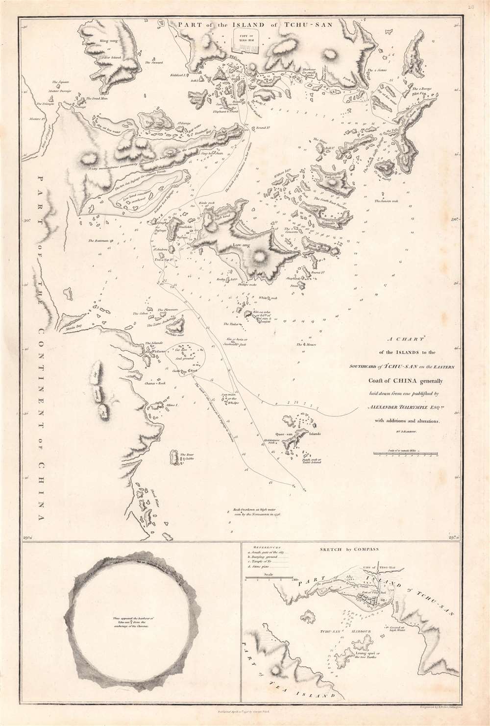

Title
A chart of the islands to the southward of Tchu-san on the eastern coast of China.
1796 (dated) 23.25 x 16.5 in (59.055 x 41.91 cm) 1 : 340000
1796 (dated) 23.25 x 16.5 in (59.055 x 41.91 cm) 1 : 340000
Description
This is a rare 1796 John Barrow map of modern day Zhoushan (舟山市; Tchu-San), China, prepared to illustrate the official report of the 1793 Macartney Embassy to China. The Embassy has been seen as a deeply consequential historical interaction between China and the British Empire which heralded the systematic crises China would face in the 19th century.
The curious sketch at bottom-left was drawn by John Barrow from the Clarence, one of the ships of the Macartney Mission. Originally a French boat, the Clarence was purchased by the mission in Batavia after one of their original ships had problems. Tracks follow the Clarence as it entered and left the Bay on its way to Dinghai.
In the Ming Dynasty, when a maritime ban was in place to dissuade widespread piracy and coastal raiding, Zhoushan was an important entrepot for trade between Chinese, Japanese, Southeast Asian, and Portuguese traders, the latter ensconced at the fortress of Shuangyu (on Liuheng Island 六橫島, here as Low-Ang, near center) until being chased off by a Ming naval expedition in 1548. At the end of the 17th century, the newly triumphant Qing Dynasty ended the maritime bans and trade was encouraged at certain ports, including Zhoushan (Dinghai). English traders, among others, stopped at Zhoushan and gained some familiarity with the local geography, producing the earliest European charts of the area. But the establishment of the Canton System of Trade in the mid-18th century confined Western traders to Canton (Guangzhou).
European traders had not forgotten Zhoushan, though, and it was a request of the failed British Macartney Mission of 1793 (discussed below) to have an island there reserved for British traders. When the First Opium War (1839 – 1842) broke out, the British moved to capture Zhoushan, which was then returned to China in exchange for Hong Kong, before being recaptured by the British later in the war (the Foreign Secretary Lord Palmerston considered Hong Kong to be of much lesser value than Zhoushan). With the rise of the treaty ports (including nearby Ningbo) and Hong Kong, Zhoushan's significance as a door to the outside world diminished.
Within China, Zhoushan is practically synonymous with fishing; historically and today, fishing is the basis of the economy and culture of the islands. Appropriately, Zhoushan is home to the largest fishery in China. In recent years, the municipality has tried to develop other industries, such as shipbuilding, as well as tourism; traditional fishing villages are particularly popular.
Led by George Macartney, earlier the Governor of Madras, the mission left Britain in September 1792 with a retinue of translators (including Chinese Catholic priests trained in Italy), painters, secretaries, scholars, and scientists. The well-equipped and impressive embassy traveled via Madeira, Tenerife, Rio de Janeiro, the Cape of Good Hope, Indonesia, and Macau, before moving up the Chinese coast (stopping at Dinghai / Zhoushan en route) and reaching Beijing on August 21, 1793. Macartney's second in command was George Leonard Staunton who served as the expedition's secretary and chronicler. Staunton's 11-year-old son, George Thomas Staunton, nominally the ambassador's page, learned Chinese during the voyage, became very adept at the language, and served as a translator for the mission alongside the Catholic priests Paolo Zhou (周保羅) and Jacobus Li Zibiao (李自標) (the younger Staunton later became chief of the East India Company's factory at Guangzhou, translated works between Chinese and English, and helped found the Royal Asiatic Society).
The Embassy was poorly managed from the beginning and, despite considerable pomp from the English perspective, appeared poor and rag-tag to the Qianlong Emperor. Partly through lack of preparation, partly through arrogance, and partly due to the emperor's distaste for the British, the Embassy failed in all its primary objectives.
Macartney's Mission highlighted cultural misunderstandings between China and the West, and has often been taken as a turning point in Chinese history – Qianlong's dismissal of foreign objects as mere toys and his insistence of the centrality of China in the world's hierarchy of kingdoms have been seen as sign of Chinese intransigence and a harbinger of China's awful course in the 19th century. At the time the Embassy visited, Qianlong had been in power for nearly sixty years and had increasingly turned over management of the empire to a small group of self-serving officials, particularly Heshen, remembered as the most corrupt official in Chinese history. In the countryside, overpopulation and famine provoked millenarian religious movements and uprisings. On the southern coast, the British East India Company began importing opium in larger and larger quantities, eventually causing a severe social and economic crisis in southern China. In retrospect, both Chinese and foreign historians of every ideological bent have seen the Macartney Mission as a missed opportunity for the Qing to recognize the tremendous changes taking place in Europe and address underlying problems that would eventually sink the empire.
A Closer Look
The map covers the area roughly composing the southern part of Hangzhou Bay to the south of Shanghai. It includes detailed navigational information for charting the many islets, rocks, and shoals of the Zhejiang coast leading to Zhoushan and the walled city of Dinghai (here as Ting-hai). In addition to transliterations of Chinese names (such as Quee-san, Tygo-san, etc.), some of the English names are translations from Chinese, such as 'Buffalo's Nose,' known in Chinese as Niubishan (牛鼻山 Buffalo Nose Mountain).The curious sketch at bottom-left was drawn by John Barrow from the Clarence, one of the ships of the Macartney Mission. Originally a French boat, the Clarence was purchased by the mission in Batavia after one of their original ships had problems. Tracks follow the Clarence as it entered and left the Bay on its way to Dinghai.
Zhoushan – China's Door to the Maritime World
The archipelago that today forms Zhoushan Municipality has a recorded history stretching well into Antiquity, and the proximity of the islands to the mainland, and particularly to the city of Ningbo (just to the west of the area shown here), made them an ideal location for fisherfolk, traders, rebels, and pirates. Its location, jutting out into the East China Sea, has historically made it a destination for foreign travelers of many stripes, including the 9th century Japanese Buddhist monk Egaku (慧锷), who founded a now-famous Buddhist pilgrimage site at Putuoshan (普陀山, here as Poo-to, at top-right).In the Ming Dynasty, when a maritime ban was in place to dissuade widespread piracy and coastal raiding, Zhoushan was an important entrepot for trade between Chinese, Japanese, Southeast Asian, and Portuguese traders, the latter ensconced at the fortress of Shuangyu (on Liuheng Island 六橫島, here as Low-Ang, near center) until being chased off by a Ming naval expedition in 1548. At the end of the 17th century, the newly triumphant Qing Dynasty ended the maritime bans and trade was encouraged at certain ports, including Zhoushan (Dinghai). English traders, among others, stopped at Zhoushan and gained some familiarity with the local geography, producing the earliest European charts of the area. But the establishment of the Canton System of Trade in the mid-18th century confined Western traders to Canton (Guangzhou).
European traders had not forgotten Zhoushan, though, and it was a request of the failed British Macartney Mission of 1793 (discussed below) to have an island there reserved for British traders. When the First Opium War (1839 – 1842) broke out, the British moved to capture Zhoushan, which was then returned to China in exchange for Hong Kong, before being recaptured by the British later in the war (the Foreign Secretary Lord Palmerston considered Hong Kong to be of much lesser value than Zhoushan). With the rise of the treaty ports (including nearby Ningbo) and Hong Kong, Zhoushan's significance as a door to the outside world diminished.
Within China, Zhoushan is practically synonymous with fishing; historically and today, fishing is the basis of the economy and culture of the islands. Appropriately, Zhoushan is home to the largest fishery in China. In recent years, the municipality has tried to develop other industries, such as shipbuilding, as well as tourism; traditional fishing villages are particularly popular.
The Macartney Mission
The Macartney Mission, or the Macartney Embassy, was a diplomatic mission by Great Britain to the Qianlong Emperor of the Qing Dynasty meant to expand British trading rights in China and establish a permanent embassy in Beijing. Thirty-five years earlier, British traders of the East India Company (EIC) were confined to trading with an officially-sanctioned set of Chinese traders in Guangzhou (Canton). Although the Canton System was profitable, the EIC found it too cumbersome and restrictive, while also feeling that a direct line to Beijing was necessary to resolve disputes (rather than working through several layers of intermediaries and bureaucrats). A mission led by Charles Cathcart had been sent to Beijing in 1787, but Cathcart died before reaching China and the embassy was abandoned.Led by George Macartney, earlier the Governor of Madras, the mission left Britain in September 1792 with a retinue of translators (including Chinese Catholic priests trained in Italy), painters, secretaries, scholars, and scientists. The well-equipped and impressive embassy traveled via Madeira, Tenerife, Rio de Janeiro, the Cape of Good Hope, Indonesia, and Macau, before moving up the Chinese coast (stopping at Dinghai / Zhoushan en route) and reaching Beijing on August 21, 1793. Macartney's second in command was George Leonard Staunton who served as the expedition's secretary and chronicler. Staunton's 11-year-old son, George Thomas Staunton, nominally the ambassador's page, learned Chinese during the voyage, became very adept at the language, and served as a translator for the mission alongside the Catholic priests Paolo Zhou (周保羅) and Jacobus Li Zibiao (李自標) (the younger Staunton later became chief of the East India Company's factory at Guangzhou, translated works between Chinese and English, and helped found the Royal Asiatic Society).
The Embassy was poorly managed from the beginning and, despite considerable pomp from the English perspective, appeared poor and rag-tag to the Qianlong Emperor. Partly through lack of preparation, partly through arrogance, and partly due to the emperor's distaste for the British, the Embassy failed in all its primary objectives.
Macartney's Mission highlighted cultural misunderstandings between China and the West, and has often been taken as a turning point in Chinese history – Qianlong's dismissal of foreign objects as mere toys and his insistence of the centrality of China in the world's hierarchy of kingdoms have been seen as sign of Chinese intransigence and a harbinger of China's awful course in the 19th century. At the time the Embassy visited, Qianlong had been in power for nearly sixty years and had increasingly turned over management of the empire to a small group of self-serving officials, particularly Heshen, remembered as the most corrupt official in Chinese history. In the countryside, overpopulation and famine provoked millenarian religious movements and uprisings. On the southern coast, the British East India Company began importing opium in larger and larger quantities, eventually causing a severe social and economic crisis in southern China. In retrospect, both Chinese and foreign historians of every ideological bent have seen the Macartney Mission as a missed opportunity for the Qing to recognize the tremendous changes taking place in Europe and address underlying problems that would eventually sink the empire.
Publication History and Census
The map was printed in 1796 to accompany Sir George Leonard Staunton's 1797 An authentic account of an embassy from the King of Great Britain to the emperor of China. It was drawn by John Barrow, based upon the cartographic work of Alexander Dalrymple (Barrow was officially the mission's comptroller, but also was an accomplished illustrator and geographer). It was engraved by Benjamin Baker and published by George Nicol. The Account appears in four institutional collections listed in OCLC, while the separate map is cataloged as being held by the National Library of Australia, the National Maritime Museum (U.K.), the Library of Congress, and the National Library of Scotland. It is scarce to the market.CartographerS
Alexander Dalrymple (July 24, 1737 - June 19, 1808) was a Scottish geographer and hydrographer active with East India Company and later as first Hydrographer to the British Admiralty. Dalrymple was born at Newhailes, near Edinburgh, Scotland, the 11th of 15 children of James Dalrymple and his wife, Christian Hamilton, the daughter of the Earl of Haddington. He joined the East India Company in 1752, at which point he was immediate sent to Madras, India. There he advocated for increased trade with the East Indies and China, negotiating a treaty with the Sultan of Sulu and visiting Canton (Guangzhou), China. He went on to develop an interest in historical voyages and navigation. In 1772, Dalrymple published his first set of charts, four of which were of the seas around Sulu. In 1779, he headed the hydrographic office of the East India Company, and that of the Admiralty in 1795. Dalrymple was instrumental in advancing the mapping of uncharted waters, particularly in the East Indies and the Pacific Ocean. He was an advocate for the existence of a large southern continent, Terra Australis, which influenced British exploration efforts. Dalrymple’s extensive work on nautical charts and navigational information significantly improved the safety and accuracy of sea voyages. His dedication to hydrography laid the groundwork for future maritime exploration. More by this mapmaker...
John Barrow (June 19, 1764 – November 23, 1848) was an English statesman, cartographer, and writer active in the late 18th and early 19th centuries. Barrow was born in the village of Dragley Beck, in Ulverston, Cumbria. His first recorded work was as a superintending clerk at a Liverpool iron foundry, but by his early 20s, transitioned to teaching mathematics at a private school in Greenwich. One of his pupils, the young son of Sir George Leonard Staunton, favored him and he was introduced to Lord George Macarteny. Barrow accompanied Macartney as a comptroller of household, on his 1792-1794, embassy to China. Having acquitted himself well, Barrow was hired by Macartney as private secretary on a political mission to the newly acquired Cape Colony, South Africa. Barrow was given the difficult task of reconciling Boer settlers with the indigenous African population. In the course of this voyage he traveled throughout the Cape Colony, coming to know that country well. There he married botanical artist Anna Maria Truter, and, in 1800, acquired a home with the intention of settling in Cape Town. Following the 1802 Peace of Amiens, the British surrendered the colony and Barrow returned to England where he was appointed Second Secretary to the Admiralty, a post he held with honor for the subsequent 40 years. In his position at the Admiralty Barrow promoted various voyages of discovery, including those of John Ross, William Edward Parry, James Clark Ross, and John Franklin. The Barrow Strait in the Canadian Arctic as well as Point Barrow and the city of Barrow in Alaska are named after him. He is reputed to have been the initial proposer of St Helena as the new place of exile for Napoleon Bonaparte following the Battle of Waterloo in 1815. He was a member of the Royal Society and the Raleigh Club, a forerunner of the Royal Geographical Society. In 1835 Sir Robert Peel conferred upon him a baronetcy. Learn More...
George Nicol (1740 - June 25, 1828) was a Scottish bookseller and publisher active in in 18th-century London. Nicol was born in Scotland, but relocated to London in 1769 to work with his uncle, the Strand bookseller David Wilson (17?? - 1777). The two eventually became full business partners, enjoying immense success. When Wilson died in 1777, Nichol took over the business in full. In 1781, Nicol was appointed official bookseller to King George III, a position he maintained until 1820. In 1787 he relocated to Pall Mall, acquiring 51 and 58 Pall Mall, one as a shop and the other as living quarters. Around 1800, his son George Nicol joined the firm, and it was renamed George and William Nicol. When the elder Nichol died in 1828, the firm continued as William Nicol until 1855. Learn More...
Benjamin Baker (1766 - June 29, 1841) was British engraver active in the late 18th and early 19th centuries. Baker was born in London, the son of instrument maker Edward Baker (1730 - 1797). As a young map he was apprenticed to Thomas Beresford, a watchmaker. This likely did not work out, as he was turned over to the engraver, mapmaker, and globemaker William Palmer (1739 - 1812). Baker rose to prominence as an engraver for the British Admiralty and British Ordnance Survey. In time he became the principal engraver for the Ordnance Survey, not only engraving himself, but overseeing the entire team of Ordnance engravers. His son, Benjamin Richard Baker (1792 - 1876) was also a mapmaker, engraver, draughtsman, lithographer, and printer. Learn More...
Condition
Very good. Some foxing and discoloration around margins.
References
OCLC 225063613, 537979940. Royal Maritime Museum, G272:2/10.