
Maps of Havana and Cuba
A panoramic tourist map of Havana.
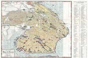
Panoramic and Monumental Map of Havana. (Plano Panoramico y Monumental de La Habana).
$450.00
Acquire
- Digital Map Information
- Suitable for large format printing
- File Size: 14.65 MB
- File Type: ZIP / TIFF
- ICC color profile embedded
- Delivered instantly via download link
This is a 1953 Rogelio L. Mirabal panoramic map of Havana, Cuba issued by the Cuban Tourist Commission, capturing the city at the height of its romantic literary period in the early fifties. The map depicts the city from Havana Bay to the Gulf of Mexico and from Rancho Boyeros International Airport to the Canal de Entrada. The Morro Castle, a fortress built at the entrance to Havana Bay, is partially illustrated in the lower right corner. Numerous buildings, monuments, and other locations throughout the city are depicted in profile, some of which, including the National Capitol building, police headquarters, Atares Castle, and Punta Castle, are identified by name. Other locations illustrated in this way are labeled numerically, and these numbers that correspond with a key situated along the map's right border, which also provides each site's grid location on the map. Neighborhoods throughout the city are labeled, as are major streets. An alphabetic street index is included along the left border. Piers along Havana's harbor are also illustrated and labeled, as are the routes of launches to Regla, Casa Blanca, and La Cabaña Fortress. (more details)