
Kellogg

Kellogg (fl. c. 1831 - 1947) designates a succession of American lithographic printing and publishing partnerships based in Hartford, Connecticut, whose output included maps, topographical views, and popular pictorial prints. Daniel Wright Kellogg (1807 - 1874), a native of Tolland, Connecticut, established D.W. Kellogg and Company in Hartford about 1831, with his younger brother Elijah Chapman Kellogg (1811 - 1881) involved in its early operations. The business opened a wholesale and retail print shop on Main Street in 1834. Daniel moved west in 1836, but his name remained in the imprint until the partnership was dissolved in July 1840, when Elijah and Edmund Burke Kellogg (1809 - 1872) continued as E.B. and E.C. Kellogg. Their cartographic work encompassed allegorical maps, including An Illustrative Map of Human Life Deduced from passages in Sacred Writ (1847), as well as landscape and town views. They also printed views drawn by other artists, including Titus H. Darrow's New Haven, from East Rock, 1853. John Chenevard Comstock joined the business in 1848; the resulting imprints were Kelloggs and Comstock through 1850 and Kellogg and Comstock in 1851. Elijah subsequently traded independently as E.C. Kellogg until Edmund rejoined him in 1855, restoring the E.B. and E.C. Kellogg imprint. The brothers' partnerships and distribution arrangements extended their business beyond Hartford, notably through a New York office established with Horace Thayer in 1846. In 1867, the business became Kellogg and Bulkeley, with Edmund's son Charles E. Kellogg participating alongside William H. Bulkeley and Frank Bulkeley. Charles withdrew in 1874, ending the Kellogg family's involvement, although its name remained attached to the firm. The successor business increasingly emphasized commercial printing and merged with Case, Lockwood and Brainard in 1947 to form Connecticut Printers, which continued until June 1990.
References: Finlay, Nancy, 'Founding Brothers: Daniel Wright Kellogg, Elijah Chapman Kellogg, and the Beginnings of Lithography in Hartford', Imprint, vol. 32, no. 2 (Autumn 2007), pp. 16 - 27. Finlay, Nancy, 'Some Evidence for the Sale and Distribution of Kellogg Prints', paper presented at Representations of Economy: Lithography in America from 1820 to 1860, Library Company of Philadelphia, October 15, 2010, pp. 4 - 5, 11 - 15, and notes 1 - 2 and 10 - 14. Adams, Doug, Research Material on Lithographs Produced by the Kellogg Lithographic Firm, 1974, Archives of American Art, Smithsonian Institution, collection AAA.adamdoug, finding aid, pp. 1 - 2.
Looking over Boston.
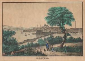
Boston.
$1,200.00
Acquire
- Digital Map Information
- Suitable for large format printing
- Full resolution TIFF file
- ICC color profile embedded
- Delivered instantly via download link
This is a c. 1862 - 1864 E. B. and E. C. Kellogg hand-colored lithographic view of Boston from Chelsea, probably adapted from William Henry Bartlett's earlier composition. It presents the city through three defining features: its crowded maritime waterfront, the State House above Beacon Hill, and the Bunker Hill Monument rising over Charlestown. A wooded foreground, occupied by a man carrying a bundle of sticks, a boy, and a dog, turns the urban prospect into a picturesque landscape suited to domestic display. The publishers' imprints point to an early 1860s issue. (more details)
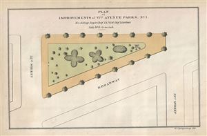
Plan of Improvements of VIth Avenue Parks, No.1.
$200.00
Acquire
- Digital Map Information
- Suitable for large format printing
- Full resolution TIFF file
- ICC color profile embedded
- Delivered instantly via download link
This is a scarce 1871 map of Greeley Square Park in New York City by Kellogg and Pilat. The map shows the plans of improvement of the park located between west 32nd St and west 33rdd St and between Broadway and Sixth Avenue. It depicts the location of trees and ... (more details)
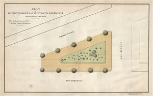
Plan of Improvements of Vith Avenue Parks, No.II.
$200.00
Acquire
- Digital Map Information
- Suitable for large format printing
- Full resolution TIFF file
- ICC color profile embedded
- Delivered instantly via download link
This is a scarce 1871 map of Herald Square in New York City by Kellogg and Pilat. The map shows the plans of improvement of the square located between west 34th st and west 35th st and between Broadway and Sixth Avenue. It depicts the location of trees and ... (more details)