This item has been sold, but you can get on the Waitlist to be notified if another example becomes available, or purchase a digital scan.
1848 House and Brown Map of Texas, California and New Mexico
TexasMexico-housebrown-1848$3,000.00

Title
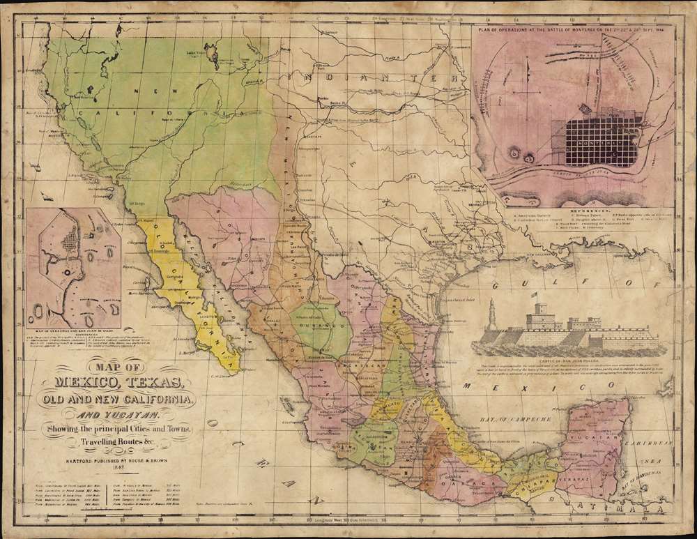
Map of Mexico, Texas, Old and New California, and Yucatan. Showing the principal Cities and Towns, Travelling Routes and c.
1848 (dated) 17 x 23.5 in (43.18 x 59.69 cm) 1 : 7300000
1848 (dated) 17 x 23.5 in (43.18 x 59.69 cm) 1 : 7300000
Description
The only known example of the 1848 edition of House and Brown's broadside map of Texas, Mexico, and Upper California, issued at the end of the Mexican-American War (1846 - 1848). The map is centered on Texas, which is presented at its largest, with its western border embracing Albuquerque and Santa Fe, and the stovepipe configuration extending its northern border to 42° N latitude. The map is elaborated by inset maps of Monterey illustrating the Battle of Monterrey (September 21 - 24, 1846) and Veracruz, Mexico. In addition, the Gulf of Mexico is occupied by a large vignette view of the fortress of San Juan de Ulúa, Veracruz. In this edition, Texas is uncolored, emphasizing that it is part of the United States, but Upper California and New Mexico are colored as Mexican intendencias, suggesting this map predates the Treaty of Guadalupe Hidalgo and must therefore have been sent to the presses sometime before February 28, 1848.
Sources
This map has been called by Carl Wheat,A shameless commercial attempt by House and Brown and the Kellogg lithographic firm to cash in on the interest in Disturnell's treaty map and Mitchell’s Mexican-American War Map of Mexico, including Yucatan and Upper California.This is, we believe, unfair. While the map clearly draws its form and some content from Mitchell's map, it adds much that the Mitchell does not. In this map, the 'Traders Route from Missouri to New Mexico' terminates in Taos. It also notes Fremont and General Kearney's Routes. Around Great Salt Lake (labeled Lake Yuta), both the American Fur Depot founded in 1832 by Antoine Robidoux (burned in 1844 by the Ute) at the future site of Salt Lake City and Uintah Fort are noted. Here, the northern border of Sonora with Upper or 'New' California correctly follows the Gila River - an omission in the Mitchell. Within south Texas, the present map offers a significantly advanced road network, naming numerous additional cities. Both maps name John Sutter's colony of New Helvetica (Sutter's Mill) and San Francisco - then little more than backwaters, but on the cusp of greatness just months before the world-famous discovery of gold at Sutter's Mill.
The Mexican-American War
The Mexican-American War was fought between Mexico and the United States over Texas from 1846 to 1848. The Republic of Texas was a short-lived nation established in March of 1836 when it ceded from Mexico. Following the independence of Mexico from Spain, the American Stephen Fuller Austin led a group of 300 Empresarios to settle Texas, near Austin, where they received a grant from the Mexican government. As more Americans moved to Texas, resentment and strife began to build between the American settlers and Mexican authorities. This and other factors ultimately led to the Texan Revolution in 1835 and the declaration of Texan independence in 1836. Texas remained an independent republic until it joined the United States 10 years later in 1846. The annexation incited Mexican authorities, who considered Texas their sovereign territory. Mexico marched against Texas and, in the aftermath, the U.S. landed forces at Veracruz and marched on Mexico City. The army, after a series of one-sided battles, captured Mexico City, forcing the Mexican government to sue for peace. In the subsequent Treaty of Guadeloupe Hidalgo, the U.S. gained most of the southwestern United States, including Texas, Arizona, New Mexico, California, Utah, and Nevada. In exchange, the U.S. paid Mexico $15 million and assumed $3.5 million in debt the U.S. claimed the Mexican government owed to American citizens.Texas Borders
The borders of the Republic of Texas were in dispute from the earliest days of the Texan Revolution. The Republic-claimed borders followed the Treaties of Velasco between the newly created Texas Republic and Mexican leader, Antonio López de Santa Anna. The treaties established an eastern boundary following the 1819 Adams-Onís Treaty between the United States and Spain, which established the Sabine River as the eastern boundary of Spanish Texas and western boundary of the Missouri Territory. The Republic's southern and western boundary with Mexico was more nuanced. Texas claimed the Rio Grande del Norte as its western and southernmost border, while Mexico argued for a boundary much further east at the Nueces River. When Texas was annexed into the United States, the agreement followed the Republic claimed boundary, thus absorbing Mexican claimed territory as far west as Santa Fe and north in a stovepipe configuration to 42° N. This escalated already existing tensions between the United States, the former Republic of Texas, and Mexico, ultimately triggering the Mexican-American War (1846 -1848).Publication History and Census
This map was printed by E.B. and E.C. Kellogg, and first published by House and Brown of Hartford, Connecticut, in 1847. The present example, issued in 1848, is the second edition, but other than the date, exhibits no cartographic changes. It does however omit the Kellogg imprint - a curious choice being as it appears on later editions. This suggests that House and Brown must have intentionally omitted it - perhaps experimenting with a different printer? Or given its rarity, perhaps this edition was a proof? A third edition was issued in 1849, of which there are two states: one with the Californian Gold Region in the Sacramento Valley highlighted and topographical updates from the Fremont Expedition; a second without the gold region, but with updated Texas boundaries and Upper California replaced by California, New Mexico, and Utah. All examples are printed on poor quality paper and most exhibit, as here, considerable wear and splotchy (although original) color. We note a further example in 1851, much revised with new topography throughout California and Utah. We have identified no other examples of this 1848 imprint.CartographerS
William Watson House (January 23, 1813 - August 7, 1882) was an American publisher active in Hartford, Connecticut, in the mid-19th century. House was born in Glastonbury, Connecticut, the son of a local farmer. He moved to Hartford when he was 15 to study bookbinding. Around 1847, along with J. Seymour Brown, he founded the publishing house of 'House and Brown'. The partnership was dissolved in 1857, but House continued to operate the imprint on his own account. Under House, the firm developed a very lucrative business shipping books to the southern states, becoming quite wealthy. This business was disrupted in 1861 with the outbreak of the American Civil War (1861 - 1865), when southern agents refused to pay their bills. With the decline of his publishing business, House took work as a tax collector for the IRS, establishing the tax department in Hartford. He later served as senior director of the First National Bank. More by this mapmaker...
J. Seymour Brown (1814 - 1893) was a Hartford based Connecticut publisher active in the mid-19th century. From 1835, he is recorded as a bookbinder in Hartford, where he mostly bound schoolbooks, a Hartford specialization. In 1841 he established a publishing and bindery firm with Sidney Drake. This business lasted until 1852. From 1847, he also partnered with William Watson House (1813 - 1882) to create the publishing firm 'Brown and House'. This firm dissolved in 1857. Following 1857, Brown is listed in Hartford directories as an 'Agent', likely a book agent working with various publishing houses. Brown was involved in the Spiritualist revival in the 1850s and is listed as the Vice President of the New England Spiritualists' Association. He was also associated with Willis Thrall, another part-time Hartford publisher, with whom he owned the 'Hartford Screw Company'. Brown must have been quite wealthy, as in 1852 he constructed a large mansion in Hartford, today preserved as the Calvin Day House (105 Spring Street). Brown died in Hartford in 1893. Learn More...
Kellogg (1836 - 1946) refers to a series of partnerships based in Hartford, Connecticut, working under different imprints active from 1836 to 1946. The firm was initially founded by Daniel Wright Kellogg (1807 - 1864), who had studied lithography in Boston. The 'D. W. Kellogg' imprint was active from 1836 - 1841. When Daniel emigrated westward in 1836, the firm was taken over by his younger brothers, Edmund Burke Kellogg (1809 - 1872) and Elijah Chapman Kellogg (1811 - 1881), who changed the imprint to 'E. B. and E. C. Kellogg'. This was the active imprint until 1848, when the brothers partnered with John C. Comstock. In a partnership that lasted until 1850 under the imprint of 'Kellogg and Comstock.' From 1851 to 1854 E. C. Kellogg worked independently under his own 'E.C. Kellogg' imprint. He again partnered with his brother in 1855, reviving the 'E. B. and E. C. Kellogg' imprint, which remained active until 1866. In 1867, Edmund and Elijah sold their share of the company to William H. Bulkeley (1840 - 1902), but a third Kellogg, Elijah's son Charles B. Kellogg, retained an interest in the firm and it continued to operate as 'Kellogg and Bulkeley' until the firm merged with Case, Lockwood and Brainard to from the still active Connecticut Printers Inc. The Kelloggs frequently worked with other printers, including Edward Ensign, Horace Thayer, and Titus H. Darrow. Learn More...
Edmund Burke Kellogg (May 27, 1809 - March 26, 1872) was an American lithographer and printer. Born in Tolland, Connecticut, Kellogg trained as a newspaper printer and was apprenticed with Samuel Green in New London, Connecticut. Kellogg joined his probers Daniel Wright Kellogg (1807 - 1874) and Elijah Chapman Kellogg (1811 - 1881) at Daniel's firm D.W. Kellogg and Company sometime in the 1830s. Around 1836, Daniel moved west, and Edmund and Elijah took over the firm. Edmund and Elijah renamed the firm E.B. and E.C. Kellogg in 1842. This firm operated until 1848, when John C. Comstock joined the brothers and the business became Kellogg and Comstock. The partnership with Comstock lasted only until 1850, and the brothers went their separate ways. Edmund and Elijah reopened E.B. and E.C. Kellogg in 1855. Elijah's son, Charles B. Kellogg, joined the firm around 1865. Edmund and Elijah sold their interest in the firm to William H. Bulkeley (1840 - 1902) in 1867. The younger Kellogg and Bulkeley partnered to form the firm Kellogg and Bulkeley. Kellogg and Bulkeley operated until 1946, when it merged with Case, Lockwood, and Brainard to form Connecticut Printers, Inc, which is still in operation today. Learn More...
Elijah Chapman Kellogg (June 13, 1811 - December 13, 1881) was an American lithographer and engraver. Born in Tolland, Connecticut, Elijah trained as an engraver under his older brother Jarvis Griggs Kellogg (1805 - 1873). Then he joined his brother Daniel Wright Kellogg's (1807 - 1874) lithography firm D.W. Kellogg and Company. Daniel moved west in 1836, which meant Elijah and his brother Edmund Burke Kellogg (1809 - 1872) took over the firm. Elijah and Edmund renamed the firm E.B. and E.C. Kellogg in 1840, and operated that business until 1848, when John C. Comstock joined the partnership. With the addition of Comstock they renamed the firm Kellogg and Comstock, but that partnership lasted only until 1850. After the partnership with Comstock fell apart, the brothers went separate ways until 1855 when they reopened E.B. and E.C. Kellogg. Elijah's sone Charles B. Kellogg joined the firm in 1865. Elijah and Edmund sold their interest in the firm to William H. Bulkeley in 1867, and the younger Kellogg and Bulkeley formed a partnership named Kellogg and Bulkeley. This firm operated until 1946 when it merged with Case, Lockwood, and Brainard to form Connecticut Printers, Inc, which is still in operation today. Learn More...
Condition
Average. Overall toning and soiling. Some repaired tears, most to margins and borders, but the largest from the top extending about 4 inches into the page. Original color.
References
Wheat, C. I., Mapping of the Transmississippi West, 1540 – 1861, #545 (1847) and #620 (1849). Day, John, Maps of Texas, 1527-1900, pp. 46-47. Garrett, J., The Mexican-American War of 1846-1848, page 414. OCLC 693612822 (1849).