
Tardieu, Pierre-Alexandre

Pierre-Alexandre Tardieu (March 2, 1756 - August 3, 1844) was a French portrait and historical engraver of the large Paris-based Tardieu family. The Tardieu family was extremely prolific, with numerous members, for over 200 years, being skilled and active engravers. Most of the Tardieu engravers simply identified themselves as 'Tardieu' or at best with their initials, so it is often extremely difficult to distinguish their individual work. Pierre-Alexandre Tardieu was the son of Pierre-Joseph Tardieu. Pierre-Alexandre was the last of the great masters of the engraving school of the 17th and 18th centuries. He worked for nearly seventy years, and was heralded for the diversity of his works. He was originally a student of his uncle Jacques-Nicolas Tardieu.
Highlights the Republic of Texas and is one of the earliest non-American maps to illustrate the Republic.
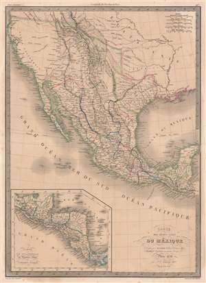
Carte des États-Unis du Méxique.
$600.00
Acquire
- Digital Map Information
- Suitable for large format printing
- DPI: 600
- File Size: 54.18 MB
- File Type: ZIP / TIFF
- ICC color profile embedded
- Delivered instantly via download link
This is an 1838 Pierre and Alexandre Lapie map of Mexico and the southwestern United States and is also one of the earliest non-American maps to include the Republic of Texas - anticipating the pending 1839 French official recognition of Texas. The Republic of Texas is bordered in yellow, highlighting its existence. Mexico is bordered in green, with its borders extending from the Yucatan to the Oregon Territory encompassing all of California and the other southwestern states. States within Mexico are labeled and bordered by thin lines of varying colors to allow for easy differentiation.
Cities and towns throughout Mexico are identified, including Mexico City, Cuernavaca, Veracruz, and Oaxaca, with Santa Fe, San Francisco, Monterey, Santa Barbara, and San Diego marked in northern Mexico, now the United States. Several Indian tribes are identified in northern Mexico, including the Apaches. A large portion of this region between the Rocky Mountains and the Pacific Coast is labeled as 'unknown'. Both the Great Salt Lake, identified as Lake Timpanogos, and Utah Lake, labeled as Lake Teguayo, are illustrated following the example of Humboldt. The apocryphal Buenaventura River is also included and is illustrated as connecting from Lake Teguayo to the Pacific Ocean, the final incarnation of the long-sought River of the West, a speculative alternative to the Northwest Passage. In the United States (as it existed in 1838) only rivers are illustrated, and a handful of Indian tribes are referenced. An inset map of Central America is situated in the lower left corner and depicts the region from the Yucatan to Chagres, Panama (labeled Colombie). (more details)
Cities and towns throughout Mexico are identified, including Mexico City, Cuernavaca, Veracruz, and Oaxaca, with Santa Fe, San Francisco, Monterey, Santa Barbara, and San Diego marked in northern Mexico, now the United States. Several Indian tribes are identified in northern Mexico, including the Apaches. A large portion of this region between the Rocky Mountains and the Pacific Coast is labeled as 'unknown'. Both the Great Salt Lake, identified as Lake Timpanogos, and Utah Lake, labeled as Lake Teguayo, are illustrated following the example of Humboldt. The apocryphal Buenaventura River is also included and is illustrated as connecting from Lake Teguayo to the Pacific Ocean, the final incarnation of the long-sought River of the West, a speculative alternative to the Northwest Passage. In the United States (as it existed in 1838) only rivers are illustrated, and a handful of Indian tribes are referenced. An inset map of Central America is situated in the lower left corner and depicts the region from the Yucatan to Chagres, Panama (labeled Colombie). (more details)
French recognition of the Republic of Texas!
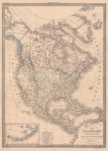
Carte de l'Amérique Septentrionale.
$700.00
Acquire
- Digital Map Information
- Suitable for large format printing
- DPI: 600
- File Size: 50.74 MB
- File Type: ZIP / TIFF
- ICC color profile embedded
- Delivered instantly via download link
This is Pierre Lapie’s 1842 map of North America highlighting the Republic of Texas. France officially recognized the nascent Republic on September 25, 1839 - before any other European power - and thus, French maps like this are some of the earliest representations of the Republic. (more details)
Includes the Republic of Texas.
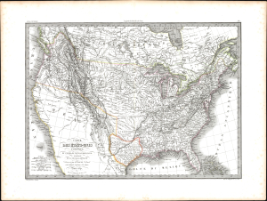
Carte des États-Unis d'Amérique, du Canada, du Nouveau Brunswick et d'une partie de la Nouvelle Bretagne.
$750.00
Acquire
- Digital Map Information
- Suitable for large format printing
- Full resolution TIFF file
- ICC color profile embedded
- Delivered instantly via download link
This is an 1841 Pierre and Alexandre Lapie map of the United States, which is one of the earliest non-American maps to include the Republic of Texas. The map depicts the region from the Pacific Ocean to the Atlantic Ocean and from 'New Britain' (Canada) to Mexico. Ephemeral geographic zones are noted, among them the Northwest Territory and the Arkansas Territory, which included the Indian Territory. The Missouri Territory encompasses all the Midwest and stretches to the Pacific Ocean. The map's color coding suggests that the borders of the United States include British Columbia. American Indian tribes, such as the Pawnee, Blackfeet, Shoshone, and Sioux, are identified. (more details)