
Arnold, Edward Greene 'Aloha Vivarttas' (sold)

Edward Greene 'Aloha Vivarttas' Arnold (September 24, 1834 - August 31, 1898) was an American marine architect, civil engineer, and inventor active in Washington D.C. and New York in the middle part of the 19th century. Arnold was born in Providence, Rhode Island, the son of Aza Arnold (1788 - 1865) and Abigail Dennis (1794 - 1877). His family was old and prestigious, having come to the United States in 1663 and settling in East Greenwich, Rhode Island. He studied architecture and engineering. Sometime in the late 1850s, the entire Arnold family, including Asa, moved to Washington D.C. to participate in the building of the new capital. In 1860, he is recorded in both the New York and the Washington D.C. Federal Censuses. In 1861 he produced, in partnership with the Colton firm, an important map of Washington D.C. After the Civil War he relocated to New York City, where he lived until 1880, when he moved to Hoboken. In New York, he successfully established himself as an architect and inventor, filing multiple patents. Sometime after the Civil War, likely in the late 1870s, Edward bizarrely changed his name to 'Aloha Vivarttas', with his wife and children also adopting the 'Vivarttas' name. Vivartta is a Hindu term from Vedic tradition meaning the 'essential material of a thing.' The unusual choice suggests that the Arnold family was associated with the Theosophical Society, a quasi-religious esoteric order rooted in mysticism tenuously connected to Hindu and Buddhist scripture. The Theosophical Society was established in New York in 1874 gaining an immediate following - roughly aligning with the name change. From this point on, 'Aloha Vivarttas' is the given name for census records and other official documentation, such as patent applications, of which he had many. He also named his children 'Vivarttas', abandoning 'Arnold' altogether. Arnold / Viarttas died in Weehawken. His son Percie A. Vivarttas (Arnold), was also a prominent architect.
A most important Civil War map of Washington D.C.
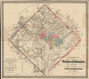
Topographical Map of the Original District of Columbia and Environs: Showing the Fortifications around the City of Washington.
sold
- Digital Map Information
- Suitable for large format printing
- File Size: 51.63 MB
- File Type: ZIP / TIFF
- ICC color profile embedded
- Delivered instantly via download link
Known as 'The Arnold Map', this is the most important Civil War era map of Washington D.C. and vicinity. This map was issued by Edward Greene 'Aloha Vivarttas' Arnold and G. W. Colton in 1862, just after the Second Battle of Bull Run. Centered on the White House, the map illustrates the 'original' ten-mile-square diamond-shaped land allocation set aside for the District of Columbia. As a cartographic piece, Arnold's map exceeded in quality all previous maps of the region, noting roads, canals, turnpikes, railroads, and mills, as well offering a meticulous presentation of topography. Significantly, it illustrates the 51 fortifications, army hospitals, and dozens of small batteries - all critical wartime reconnaissance. (more details)