
Bauman Jr., William (sold)

William Bauman Jr. (1866 - July 16, 1933) was an American draftsman. Born in Maryland, Bauman Jr. worked for the General Land Office from the 1890s through at least the mid-1920s. He married Cora Walker (March 15, 1868 - January 18, 1904) on September 12, 1899, with whom he had two children. After retiring from the General Land Office (the historical record does not tell us when he retired), he moved to Florida with his second wife, Rosa, and died in Tampa on July 16, 1933.
An Encyclopedia of Arctic Exploration.
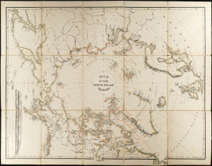
Map of the North Polar Region.
sold
- Digital Map Information
- Suitable for large format printing
- File Size: 356.13 MB
- File Type: ZIP / TIFF
- ICC color profile embedded
- Delivered instantly via download link
This 1879 William Bauman map of the North Pole surveys over 400 years of Arctic exploration. It was produced to accompany the posthumous report of Captain Charles F. Hall's final, fatal expedition to determine the fate of the British Arctic explorer, Sir John Franklin. It includes dated notations pertinent to Franklin and Hall's journeys, as well as the accomplishments of approximately 17 explorers reaching back to the 16th century, including the explorations of the Siberian coast by Adolf Erik Nordenskiöld (1832 - 1901) in his successful search for a northeast passage. (more details)
Arizona after statehood.
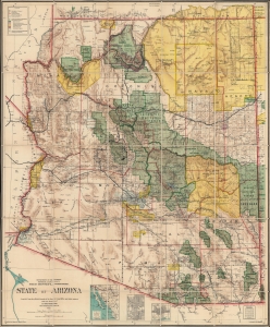
State of Arizona.
sold
- Digital Map Information
- Suitable for large format printing
- Full resolution TIFF file
- ICC color profile embedded
- Delivered instantly via download link
This is the 1912 Ithamar Berthrong and Daniel O'Hare map of Arizona - among the first official U.S. government maps Arizona as a state. (more details)