
Beauplan, Guillaume Levasseur de (sold)

Guillaume Levasseur de Beauplan (c. 1600 – 1675), sometimes as William le Vasseur de Beauplan, was a French-Polish cartographer and engineer. The details of his life are uncertain and disputed. He was likely born to a noble Huguenot family in Dieppe and served in the French army before being hired by the Polish crown to design fortifications in what is now central and eastern Ukraine. His experience in the region led to his being tasked with producing the first comprehensive maps of Ukraine, first printed in 1648. He continued to produce maps and descriptions of Ukraine, which became widely distributed throughout Europe in several languages.
Among the earliest maps of the Dnipro River.
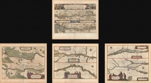
Tractus Borysthenis, Vulgo Dniepr er Niepr dicti.
sold
- Digital Map Information
- Suitable for large format printing
- Full resolution TIFF file
- ICC color profile embedded
- Delivered instantly via download link
A beautiful 1662 original-color set of Joan Blaeu maps of the Dnipro (Dnieper) River, the Ukrainian frontier of the Polish-Lithuanian Commonwealth. At the time, the region was undergoing a radical rearrangement, with Poland-Lithuania ejected as the major outside power and replaced by Tsarist Russia. (more details)