
Bergelin, L. (sold)

L. Bergelin (fl. c. 1930 - c. 1972) was a French cartographer active during the mid-20th century. He produced school wall maps, world maps, and city plans, notably of Paris. From 1838, he also worked on the Peugeot road atlas beginning.
French voyages of discovery from the 15th through the 19th century.
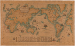
Voyages des Découvertes et d'Explorations des Marins Français depuis le XVe. siècle.
sold
- Digital Map Information
- Suitable for large format printing
- File Size: 197.55 MB
- File Type: ZIP / TIFF
- ICC color profile embedded
- Delivered instantly via download link
This is a 1930 L. Bergelin pictorial map of the world celebrating French voyages of discovery from 1402 to 1840. This map appeared at the end of the Années folles, a post-World War I period of rich social, artistic, and cultural innovation centered in Paris. It coincided with a resurgence of French national pride, much of which was expressed in novel new forms of art that combined advances in printing, the rise of propaganda imagery, and egalitarian social values. (more details)