
Buchanan, Nathaniel Claiborne (sold)

Nathaniel Claiborne Buchanan (c. 1885 - 1969) was a civil engineer active in Florida in the early 20th century. Details on Buchanan's life are somewhat scant. He was either born in Kentucky or born in Missouri and moved to Kentucky at a very young age. In 1910, he married Nina Butt of Springfield, Ohio, with whom he had four children. After marriage, Buchanan lived with his family in Scioto County, Ohio. From 1925, he was in Fort Pierce, Florida. He had training as a civil engineer and surveyor, but his only known cartographic work is a 1925 cadastral map of Fort Pierce. By 1940 Buchanan was working for the federal government. He may have also worked for the Florida State Road Department office in DeLand in the late 1940s.
Peak of the Florida Real Estate Boom.
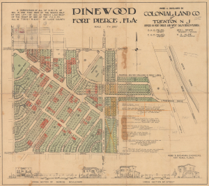
Pinewood Fort Pierce, Fla.
sold
- Digital Map Information
- Suitable for large format printing
- Full resolution TIFF file
- ICC color profile embedded
- Delivered instantly via download link
This is a 1925 cadastral map by Elmer Robb and Nathaniel C. Buchanan of a planned housing development in Fort Pierce, Florida, drawn for the development's financiers, the Colonial Land Company of Trenton, New Jersey. It was prepared during the height of the Florida Real Estate Boom of the 1920s and represents both the potential benefits and the pitfalls of the era's heady atmosphere. (more details)