
Carta (sold)

Carta (1958 - Present; כרטא) is an Israeli publisher of maps and atlases. Also known as 'Carta-Jerusalem' and 'Carta, The Israel Map and Publishing Company, Ltd.', the firm's primary focus is biblical subjects. One of the principal cartographic publishers in Israel, the firm publishes Israel's national atlas alongside motorist road maps. The firm is also known for its historical atlases, and is the licensed publisher of the Hebrew edition of the Guinness Book of World Records. Carta was founded by Emanuel Hausman (עמנואל האוזמן) and Amnon Soferman (אמנון סופרמן).
Visualizing the Indochina Wars in Israel.
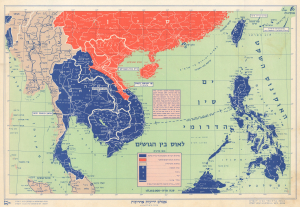
This is a c. 1960 map of Southeast Asia produced by the Israeli cartographic firm Carta for Ben-Zion Luria's Aṭlas Yedi'ot Aharonot. It highlights the Cold War ideological struggles in the region, particularly the Laotian Civil War (1959 - 1975). (more details)
Israel's Growing Travel and Tourism Industry.
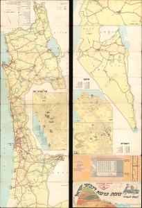
מפת כרטא לכבישי ישראל לנופש ולמטייל / [Carta Map of Israel Roads for Vacationers and Travelers].
sold
A colorful 1966 road map of Israel, prepared by the firm Carta, based in Jerusalem. It reflects the development of Israel's road network, domestic tourism, and consumer economy in the decades after statehood. (more details)
Safe and secure sightseeing after the Six-Day War.
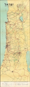
A scarce 1969 Zionist road map of Israel, produced by the Jerusalem firm Carta. Designed like a strip map, mimicking the elongated shape of Israel, the map provides information for motorists and travelers while also reflecting (and endorsing) the post-1967 / Six Day War borders of Israel. (more details)
Israel's technological and economic center.
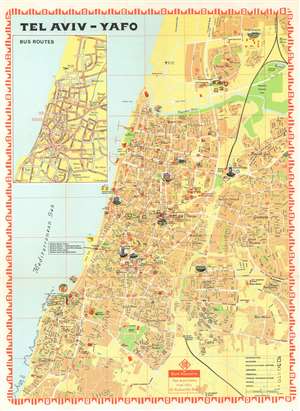
This is a 1974 Carta pictorial city plan or map of Tel Aviv, Israel. Depicting the city from Tel Aviv University to Givat Aliya, streets throughout the city are illustrated and labeled. Pictorial vignettes highlight buildings around the city, including Tel Aviv University, the F. Mann Auditorium, Laski Planetarium, and Shalom Mayer Tower. Museums, libraries, cultural centers, and hotels are identified as well. Red diamond shapes mark branches of the Bank Hapoalim throughout the city. An inset highlighting the city's many bus routes occupies the upper left quadrant. (more details)