
Child, George (sold)

George Child (born 1706, fl. 1737-1753) was an English engraver, based in London. The son of a gardener, he was given a charitable apprenticeship as a goldsmith in 1720 (not an uncommon early training among engravers.) He produced maps for the English edition of du Halde’s ‘description the empire of China and Chinese-Tartary’ and Thomas Astley’s ‘New General Collection of voyages and travels,’ among other works. He was also known for his landscapes and views.
First Accurate English Map of Tibet.
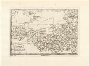
A Map of Great Tibet, drawn from that made by Lama Mathematicians in 1717.
sold
- Digital Map Information
- Suitable for large format printing
- Full resolution TIFF file
- ICC color profile embedded
- Delivered instantly via download link
This is the earliest English map of Tibet, engraved for Braddock Mead's A New General Collection of Voyages and Travels, published under his pseudonym 'John Green' by Thomas Astley in 1747. It is one of the few maps of the region to rely (ultimately) on local sources - although the mapmaker's claim that the map was 'drawn from that made by Lama Mathematicians' does not include the chain of Jesuit missionaries and French cartographers linking the 'Lama Mathematicians' to the 'English engraver'. The map covers an area from northern India (Delhi is shown) to encompass the Gobi Desert and as far as Kashgar. The map includes Lake Kokonor in the Qinghai Province of China, and embraces what is now the Xinjiang Uyghur Autonomous Region. The Himalaya Mountains of Tibet appear pictorially, but the map is rich in place names and rivers, including several rivers disappearing into the endoheiric basins of the Gobi. (more details)