
China Geographical Model Manufactory (sold)

China Geographical Model Manufactory (fl. c. 1950 - c. 1985) was a map publishing and geographical modeling firm based on Nathan Road in Kowloon, Hong Kong, in the middle part of the 20th century. The firm was active as early as 1940, but produced the bulk of their maps in the 1960s and 70s. They are known for publishing multiple maps and some of the writings of the geographer Liang Jisen (1920 - 20??).
Charming map of Hong Kong.
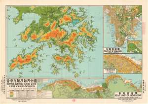
Hong Kong and The New Territories. / Road Map of Kowloon. / Victoria City. / Road Map of Hong Kong.
sold
This is a 1977 China Geographical Model Manufactory map of Hong Kong and the New Territories. The map depicting the entire region from China to Po Toi Island and from Tai Shan Bay to Mirs Bay occupies over half the sheet and provides incredible detail. Cities and towns are labeled in both Romanized Chinese and Chinese characters, along with mountain ranges, peaks, and passes labeled in the same manner. Other locations, such as rivers, reservoirs, bays, harbors, and coves are treated similarly. The region's topography is illustrated using color with dashed lines providing a boundary of sorts between the different elevations. A key, situated in the lower left corner, provides information concerning the various notations used and measurements used to differentiate topography. Three smaller maps frame the map of Hong Kong and the New Territories to its right and below it. (more details)