
Converse, Sherman (sold)
Sherman Converse (April 17, 1790 – December 10, 1873) was an American printer, publisher, and bookseller active in New Haven, Connecticut, in the early 19th century. Converse was born in Thompson, Connecticut. He studied at Monson Academy and was the first from that school to attend Yale College, from which he graduated in 1813. On March 4 of 1817 he acquired the Connecticut Journal, which he published until 1826. He also published the American Journal of Science and Arts (1820 – 1826), the Christian Spectator (1821 – 1825), Swift's Digest of Connecticut Laws, (1822 – 1823), and the first edition of Noah Webster's Dictionary (1828). He was additionally the official printer for Yale College from 1819 – 1825. His cartographic work is limited, but he did partner with fellow Yale graduate Jedidiah Morse (1761 – 1826) and his brother Richard Morse (1795 – 1868) to publish the 1823 New Universal Gazetteer. He also published an important anti-piracy broadside and map with N and S.S. Jocelyn in 1825. He sold the interest in most of his Connecticut enterprises in 1826 and relocated to New York City, establishing there a book and publishing company. From 1838 to 1844 lived in Quebec to be closer to his son, George Sherman Converse (1828 - 1895), who was studying there. In 1850, he acquired a severe rheumatic disorder which left him an invalid for the remainder of this days. He lived with his son in Boston Highlands, Massachusetts from 1863 until his death in 1873.
Rare Broadside Map chronicling the last resurgence in piracy in the West Indies.
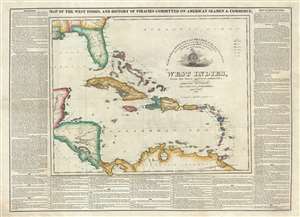
Map of the West Indies, and the History of Piracies Committed on American Seamen and Commerce. / To the Gallant Officers and Seamen of the American Navy, the Protectors of our Commerce in the West India Seas this Map Is Respectfully Inscribed by the Publishers. / West Indies, from the latest and best authorities.
sold
- Digital Map Information
- Suitable for large format printing
- DPI: 300
- File Size: 20.03 MB
- File Type: ZIP / TIFF
- ICC color profile embedded
- Delivered instantly via download link
A remarkable, separately issued, and extremely rare 1825 broadside map by Nathaniel and Simeon Smith Jocelyn of New Haven, Connecticut, responding to the last great outbreak of West Indian piracy between 1817 and 1825. It responds with gratitude to the defending ... (more details)