
Cooper and Stone (sold)

Cooper and Stone (fl. c. 1865 - 1867) was an American lithographic and engraving firm based in New York City. The firm was actively only briefly, with their earliest work dating to 1865, and their latest to 1867. They engraved an unsuccessful printing of the Declaration of Independence, a several maps for John Bute Holmes, and a map of the United States.
One of the few early maps to note the 18th century African American Cemetary between Duane and Reade Streets.
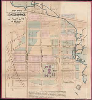
Map of Property Lying on each Side pf Broadway formerly known as the Calk Hook accurately made from Old Deeds Maps and Other Reliable Sources by J. B. Holmes, C.E. City Surveyor.
sold
- Digital Map Information
- Suitable for large format printing
- File Size: 25.85 MB
- File Type: ZIP / TIFF
- ICC color profile embedded
- Delivered instantly via download link
This is of John Bute Holmes's 1865 map of Tribeca, New York City. This is one of the earliest specific maps of the Tribeca area and the best all-around map of the area to the west of the Collect Pond (now the Federal Building and Collect Pond Park), showing all feeder streams and some topography. It also includes one of the earliest specific mentions of the African American Burial Ground located just south of Duane Street. In modern terms, the map covers the region from Howard and Canal Street south to Reade Street, and from Hudson Street to Federal Plaza. The city Hospital Plaza, located between Worth and Duane Street, is noted but these buildings have long since disappeared. (more details)