
Crawford, Charles G. (sold)

Charles G. Crawford (c. 1830 - 1907) was a printer active in New York, most prominently as part of the partnership Wynkoop (sometimes as Wyncoop), Hallenbeck, Crawford. Beginning in stationary and then moving into other fields of printing, including map printing, Crawford was associated for much of his early career with the Martin B. Brown Company. Despite his employment and partnerships, he is noted as printed on multiple late 19th and early 20th century folding maps, particularly those of railroads in the southeastern United States.
The 'Plant System' and early Railroad access to Tampa.
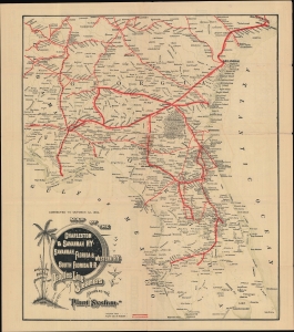
Map of the Charleston and Savannah RY. Savannah, Florida and Western RY. South Florida R.R. and all the routes operated by the peoples line of steamers known as the 'plant system.'
sold
- Digital Map Information
- Suitable for large format printing
- Full resolution TIFF file
- ICC color profile embedded
- Delivered instantly via download link
An 1884 folding map of a portion of the southeastern United States, printed by C. G. Crawford and published by Thomas Cook and Son, highlighting railroad infrastructure. More specifically, it focuses on the 'Plant System,' a series of railroads acquired by business magnate and architect of Tampa Bay, Henry B. Plant. (more details)