
Crocker, Henry Smith
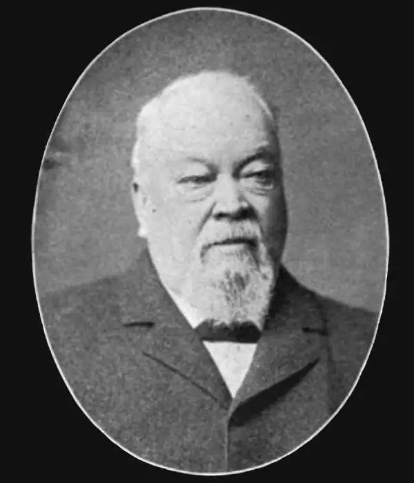
Henry Smith Crocker (January 31, 1832 - July 18, 1904) was an American printer, publisher, and railroad investor active in northern California in the middle to late 19th century. Crocker followed the Gold Rush to California, settling in Sacramento in the 1850s. He established his printing concern, H. S. Crocker, in 1856. Apparently his first office was little more than a tent with a small sign. Crocker relocated to San Francisco in 1871. He became extremely wealthy almost overnight by leveraging his ties to the Central Pacific Railroad, which is brother, Charles Crocker (1822 - 1888) founded. In 1885, Crocker constructed a large five-story printing factory, powered by his own private steam plant, then the largest and most sophisticated printing concern on the west coast. Crocker's prosperity continued and by the time he died in 1904, he was the head of a large and wealthy family. Although Crocker passed on, his company, H.S. Crocker, continued to operate and remains active to this day.
Oakland just before its industrial bo
om.
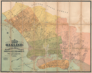
Map of Oakland and Vicinity. Alameda, Berkeley, Fruitvale, and Piedmont.
$3,000.00
Acquire
- Digital Map Information
- Suitable for large format printing
- Full resolution TIFF file
- ICC color profile embedded
- Delivered instantly via download link
This is a c. 1892 William J. Dingee city plan or map of Oakland, California, and the surrounding East Bay area. Published just before Oakland experienced a decades-long boom following the Panic of 1893 in which the city became in industrial center, streets are illustrated and labeled throughout Oakland, Berkeley, Albany (incorporated in 1908), Emeryville (incorporated in 1896), Piedmont, Alameda, and Brooklyn Township. (more details)
Train and steamship from San Francisco to New York.
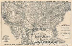
Correct Map of the Railway and Steamship Lines Operated by the Southern Pacific Company.
$650.00
Acquire
- Digital Map Information
- Suitable for large format printing
- Full resolution TIFF file
- ICC color profile embedded
- Delivered instantly via download link
This is an 1893 H. S. Crocker and Southern Pacific railroad map of the United States, promoting transcontinental rail travel. Bold lines trace Southern Pacific's routes through the southern United States, throughout California, north along the west coast to Portland, Oregon, and east to Ogden, Utah, where it connected with the Union Pacific. Towns serviced along Southern Pacific's routes are identified. While Southern Pacific's rails did not make it all the way to New York, dashed lines highlight steamship connections between New Orleans and New York, as well as Cedar Key and Punta Gorda, Florida. The rest of the nation's railroad network appears as well, underscoring the incredible ability to travel almost anywhere. (more details)
The Gold Rush in San Francisco.

San Francisco in July 1849 from Present Site of S.F. Stock Exchange.
$2,000.00
Acquire
- Digital Map Information
- Suitable for large format printing
- File Size: 43.53 MB
- File Type: ZIP / TIFF
- ICC color profile embedded
- Delivered instantly via download link
A fine 1894 chromolithograph George Henry Burgess view of San Francisco depicting the city in 1849, at the height of the California Gold Rush. Burgess drew this view based on sketches drawn from life in 1849, shortly after his arrival in San Francisco. He compiled these into a painting in 1891. It was transferred to lithographic stone, as here, in 1894. The view looks westward along Montgomery Street with Telegraph Hill prominent in the distance. A temporary camp of newly arrived 49ers fills the foreground, with two mounted Californios riding out of town at left. New construction and warehouses occupy the center, with the busy harbor at right bringing in waves of 49ers. This is essentially today's Financial District. There is a key to the map in the lower left, identifying all prominent locations throughout the growing city. (more details)
Sonoma Wine Region.
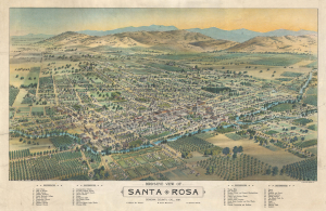
Bird's-Eye View of Santa Rosa Sonoma County, Cal, 1897.
$3,000.00
Acquire
- Digital Map Information
- Suitable for large format printing
- File Size: 122.9 MB
- File Type: ZIP / TIFF
- ICC color profile embedded
- Delivered instantly via download link
A striking 1898 H. S. Crocker chromolithograph bird's-eye view map of Santa Rosa, Sonoma County, California. This is one of the earliest images to reference winemaking in Sonoma County. (more details)