
Veer, Gerhardo de (sold) (Gerhardo de Veer, Gerard de Veer)

Gerrit de Veer (c. 1560 - 1625) was a Dutch mariner, Arctic chronicler, and map compiler associated with Amsterdam and the late 16th-century search for a Northeast Passage to Asia. Born probably in Amsterdam around 1570, he was the son of the Amsterdam historian Ellert de Veer (1540 - 1599) and studied navigation under Robert le Canu. His principal cartographic contribution was the illustrated account of three Dutch Arctic expeditions, Waerachtighe beschryvinghe van drie seylagien, published at Amsterdam in 1598. Although his narrative covered the voyages of 1594, 1595, and 1596 - 1597, de Veer personally accompanied only the second and third expeditions, sailing with Willem Barentsz (c. 1550 - 1597). The maps and plans accompanying his account documented the approaches to Novaya Zemlya, Yugorsky Strait, the northern Russian coast, and the survivors' return route toward Kola. These publications incorporated Barentsz's observations rather than representing wholly independent surveys by de Veer; the chart of Novaya Zemlya and adjacent coasts was engraved by Baptista van Doetecum. During the final expedition, de Veer survived the winter of 1596 - 1597 in a wooden shelter on northeastern Novaya Zemlya after the expedition's ship became trapped in ice. The crew subsequently departed in two open boats, and Barentsz died during their return journey. De Veer reached Kola with the survivors and returned to Amsterdam in 1597. His account, issued in several languages, preserved both geographical information and a detailed eyewitness record of the expedition. Little is securely documented about his later career; his exact death date and place remain unknown, although a letter from his former navigation teacher indicates he died before 1627.
AKA: Gerhardo de Veer, Gerard de Veer
A seminal map in the search for a Northeast Passage to Asia.
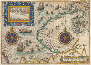
Tabula terrae Nouae Zemblae in qua fretum sinusq Waigats item ord littorialis Tartariae atq Russiae, ad urgem usq Kildeinam ….Authore Gerhardo De Veer.
sold
- Digital Map Information
- Suitable for large format printing
- DPI: 300
- File Size: 3.54 MB
- File Type: ZIP / TIFF
- ICC color profile embedded
- Delivered instantly via download link
A highly important map regarding the early search for a Northeast Passage. This remarkable map was drawn in 1601 by Theodore de Bry to describe the ill fated third voyage of the Dutch explorer William Barentsz in search of the Northeast Passage. The map depicts ... (more details)