
Dye, John H. (sold)

John H. Dye (September 9, 1833 - 19??) was a Philadelphia based draughtsman, government official, surveyor, and mapmaker active in the middle part of the 19th century. Dye was born in Kensington, Pennsylvania, to which his parents William and Christiana Dye migrated after leaving Rhode Island. Dye studied civil engineering under James P. Davis, his uncle, and took a position under Strickland Niece, chief engineer of Philadelphia. In 1865 Dye was appointed to create and manage the Registry Bureau of the Philadelphia Survey Department, a position which he held for 31 years. The bureau, under Dye's direction compiled and sold Philadelphia city and district plans for both official and public use, these included civic improvement, legal matters, land purchase and sale, cemetery management, and the construction of the city's sewer system. Dye served as a Union officer in the American Civil War. He was also active in his local Masonic Lodge, where he attained the 32nd degree of the Scottish Rite. Later, in 1885 he was elected Chair of the Engineers Club of Philadelphia. Die was active until at least 1896. The date and place of his death is unknown.
One of only three known examples, this map marks a major milestone in the urban mapping of Philadelphia, and is one of the first to show Fairmount Park's design.
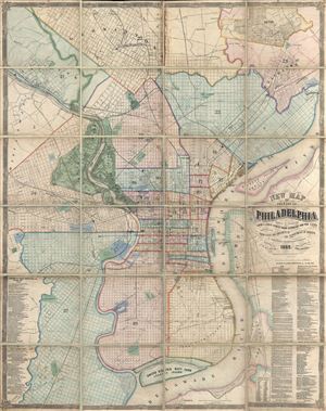
New Map of the City of Philadelphia, reduced by Photography from a large survey made expressly for the City and corrected from Plans and Draughts in the Department of Surveys, by John. H. Dye, Draughtsman and Surveyor.
sold
- Digital Map Information
- Suitable for large format printing
- File Size: 104.62 MB
- File Type: ZIP / TIFF
- ICC color profile embedded
- Delivered instantly via download link
An exceptional 1869 folding wall map of Philadelphia, Pennsylvania by John H. Dye and Henry J. Toudy. This map covers the urban center of Philadelphia along both sides the Delaware and Lehigh Rivers from roughly Germantown to Red Bank and from Haddington to ... (more details)