
Freyhold, Edward (sold)

Edward Freyhold (May 12 1824 - November 29 1892, born Eduard Otto Gotthilf Julius von Freyhold) was a German-born American cartographer, topographer and draughtsman. Nothing is known about his education and training, but his long association with fellow German immigrant Julius Bein suggests that from an early age he worked with that map publisher, perhaps as an apprentice. He served in the Pennsylvania Infantry from 1861 to 1866, and his skills as a draughtsman and mapmaker were for decades placed at the service of his adopted homeland. Freyhold became a prominent topographer and draughtsman whose work can be found on numerous maps of the West for the government and the railroads, appearing in print between 1853 and 1879. Map scholar Carl Wheat rhapsodized about his work:
Edwin (sic) Freyhold… was an unrivaled expert in this type of work. His penned originals are almost unbelievably delicate, and must be examined with a powerful magnifying glass to be appreciated... Freyhold was later the author of a beautiful map of the Transmississippi West published in 1868. It contains all the material he could locate resulting from explorations and surveys made subsequent to those used by Warren. No other maps of this region, even those of the present day, seem superior to these two great maps in workmanship. ... A Freyhold manuscript map, however, is... something of great beauty.
Scarce, Superbly Detailed Map of the Northwestern Territories and States: First Detailed Map Naming the Wyoming Terrirory
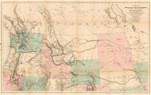
General Map of the North Pacific States and Territories Belonging to the United States and of British Columbia, Extending from Lake Superior to the Pacific Ocean and Between Latitude 39 degrees and 53 degrees North. Exhibiting Mail Routes, Gold Mines, and Including the Most Recent Surveys of the Topographical Bureau. Prepared by Captain John Mullan. ... Drawn by Edward Freyhold, T.E. Lithographed by J. Bien, 24 Vesey, St. N.Y.
sold
- Digital Map Information
- Suitable for large format printing
- File Size: 44.63 MB
- File Type: ZIP / TIFF
- ICC color profile embedded
- Delivered instantly via download link
This the 1865 Mullan - Freyhold map of the American Northwest. It shows the territories of Washington, Idaho, Montana, Wyoming, Dakota and Nebraska, and the State of Oregon in completion, and portions of California, Minnesota, Iowa, Kansas, Colorado, Utah and Nevada. The lithographed map - with hand wash color to distinguish the territories from one another - is beautifully executed and detailed. Carl Wheat esteemed this 'very fine' map so well that he chose it for the frontispiece of the fifth volume of Mapping the Transmississippi West. In discussing Freyhold, in particular, Wheat rhapsodizes:
Edwin (sic) Freyhold, who seems to have been responsible for the actual drawing of the topography, was an unrivaled expert in this type of work. His penned originals are almost unbelievably delicate, and must be examined with a powerful magnifying glass to be appreciated.Indeed, the map's details are superbly drafted and lithographed, with clear, legible typography and beautifully hachured mountains. The map, and the guide accompanying it, was intended to aid and encourage hopeful emigrants to the new territories of the northwest, particularly prospectors. The map relies heavily on data arising from Mullan's tenure as superintendent of construction for the northern military wagon road running from Walla Walla to Fort Benton on the upper Milk River, and indeed Wheat specifically praises the detail of its trails: Mullan's road is shown in its several variants, including Mullan' proposed (and rejected) route to Walla-Walla via Fort Laramie. Another route following the Yellowstone River west and crossing the mountains via Beaver Head Valley is indicated to the south of the Mullan road. Well-established U.S. Mail routes are shown in the southern part of the map. (more details)