
Gehüchte, Augustin van de (sold)

Augustin van de Gehüchte (fl. c. 1841 - 1860) was a Belgian surveyor and civil engineer active in Guatemala during the middle part of the 19th century. Little is known of Gehüchte's early years. He was most likely born in Belgium. His cartographic skills suggests military training. In 1841, he was sent to Belgium as part of the Compagnie Belge, a short lived Belgian colonial venture in Guatemala (noted on this map). After Guatemalan independence under Rafael Carrera Turcios (1814 - 1865), Gehüchte, as the country's only skilled surveyor and mapmaker, became instrumental in the development of the country, surveying roads, private land exchanges, and national borders.
The first official map of Guatemala! A cornoerstone piece for Central American 'Decolonization'!
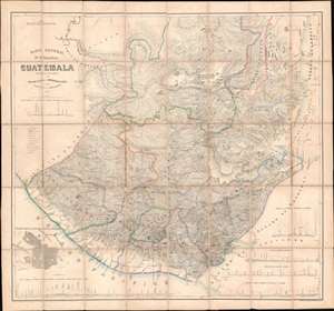
Mapa General de la Republic de Guatemala.
sold
- Digital Map Information
- Suitable for large format printing
- File Size: 79.73 MB
- File Type: ZIP / TIFF
- ICC color profile embedded
- Delivered instantly via download link
A seminal production, this 1959 map by Maximilian von Sonnenstern and August van de Gehüchte is the first official map of Guatemala and a key document associated with Guatemalan independence. The map was commissioned by first president of Guatemala, Rafael Carrera Turcios (1814 - 1865), and is the first broadly accurate meticulously detailed map of that country. The enduring legacy of this map includes its role in establishing and legitimizing Guatemala, as well as its significant evidentiary rule in subsequent Guatemalan boundary disputes and negotiations. In addition, this is the first to accurately map Guatemala's many important Mayan ruins. (more details)