
Holle, Lienhart (sold)

Lienhart Holle (? - 1492) was a German printer, living and working in Ulm. He is most noted for his 1482 Ptolemy, the first edition of Geographia printed north of the Alps. Little is known of his life. He appears in the historical record in 1478 as a formschneider and woodcut dealer, among other things printing playing cards. He would then become the third book printer in Ulm, producing some outstanding works of the incunable period, most notably his edition of Ptolemy. Masterpiece though this was, it ruined him financially within two years of its publication. The elaborate designs of his books made them extravagantly expensive to produce, and he could only raise the capital by borrowing it, mortgaging his printing materials to a Venetian patron, Justus de Albano. As with many early printed works, a broad market failed to materialize, and Holle was unable to pay his debts. De Albano seized the blocks and typeset for nonpayment, and Holle was forced to flee Ulm in 1484. He is thought to have attempted a return to the city in later years but there is no record of him that appears after 1492.
The Most Beautiful 15th Century Map of the World.
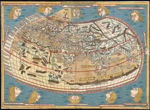
[Untitled map of the World].
sold
- Digital Map Information
- Suitable for large format printing
- DPI: 600
- File Size: 18.86 MB
- File Type: ZIP / TIFF
- ICC color profile embedded
- Delivered instantly via download link
This is a beautiful example, in rich original color, of the world map of the 1486 Ulm Ptolemy: regarded as the most beautiful, printed world map of the 15th century. The present example is one of the finest to appear on the market in recent years. It appeared in the first edition of Ptolemy printed north of the Alps, and as such it provided the foundation for the revolution in geographical knowledge that occurred in the opening years of the 16th century. The 'world' as depicted here is mainly the Oikumene, the inhabited world as it was known to 2nd century Romans. It covers the 'Old World' from the islands of the Atlantic Ocean (both real and legendary) to Indochina, and from the Arctic to the Tropic of Capricorn. But this was also the first printed world map to depart from a purely Ptolemaic model, offering more contemporaneous knowledge: the early depiction of Scandinavia and Iceland. (more details)