
Huntington, Francis Junius

Francis Junius Huntington (December 3, 1802 - February 5, 1878) was an American publisher of books and later music. Born in Suffield, Connecticut, Huntington was the son of Hezekiah Huntington, who fought in the American Revolutionary War (1775 - 1783), worked as a prominent attorney in Connecticut after the war, and was appointed District Attorney for Connecticut by President Thomas Jefferson in 1806. Francis Huntington grew up in Hartford, Connecticut. He entered the publishing world in Hartford at a young age and soon found success in his chosen field as a bookseller, printer, and publisher. Atlases, geography books, and textbooks were among the many works he published. He moved to New York City in 1862 where he began publishing musical books. He died in New York in 1878. He married Stella Bradley Bull on September 1, 1833, with whom he had seven children, three of which died in childhood.
Inspiration for H P. Lovecraft!
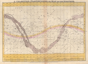
A Celestial Planisphere, or Map of the Heavens.
$350.00
Acquire
- Digital Map Information
- Suitable for large format printing
- DPI: 600
- File Size: 40 MB
- File Type: ZIP / TIFF
- ICC color profile embedded
- Delivered instantly via download link
This is a rare 1833 Elijah Burritt hand-colored map of the night sky. Centered on the Ecliptic, this map identifies zones associated with major constellations. The Milky Way is shaded. A scale exhibiting the Sun's place in the ecliptic at various times of the year appears below the map proper. This map, like all of Burritt's charts, is based on the celestial cartographic work of Ignace-Gaston Pardies (1635 - 1673) and Johann Gabriel Doppelmayr (1677 - 1750). (more details)
Lovecraft inspiration!
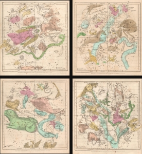
January February March. / April May June. / July August September. / October November December.
$900.00
Acquire
- Digital Map Information
- Suitable for large format printing
- Full resolution TIFF file
- ICC color profile embedded
- Delivered instantly via download link
This is an 1835 set of maps by Elijah Burritt depicting the night sky throughout the year. Each sheet features the stars and constellations in the night sky over a quarter of the year. On each of the charts, the constellations are drawn in detail and include depictions of the Zodiacal figures the stars were believed to represent. (more details)
Lovecraft inspiration!
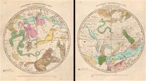
Northern Circumpolar Map for each Month in the Year. Southern Circumpolar Map for each Month in the Year.
$500.00
Acquire
- Digital Map Information
- Suitable for large format printing
- Full resolution TIFF file
- ICC color profile embedded
- Delivered instantly via download link
This is a beautiful hand-colored set of the 1835 Elijah Burritt northern and southern circumpolar celestial maps. This pair illustrates the night sky and constellations of both the northern hemisphere and southern hemisphere respectively. Constellations are drawn in detail and include depictions of the zodiacal figures (more details)
The relative size and distance of the planets in the Solar System.
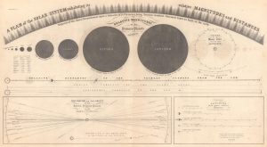
A Plan of the Solar System exhibiting its relative Magnitudes and Distances.
$200.00
Acquire
- Digital Map Information
- Suitable for large format printing
- File Size: 45.04 MB
- File Type: ZIP / TIFF
- ICC color profile embedded
- Delivered instantly via download link
This is an 1856 Elijah Burritt celestial chart of the Solar System. The central chart illustrates the relative magnitude of the planets, providing an understanding of the size of the primary planets in relation to one another, with sizes relative to the Earth provided as well. The arc of large and small triangles illustrates a part of the Sun on the same scale as the other planets! A chart below illustrates the primary planets' relative size and distances from the Sun. Two sub charts occupy the bottom third of the sheet and detail the orbital inclination of several primary planets to the plane of the Ecliptic and the distances of the satellites from their several primaries. (more details)
Rangeley Lakes Region.
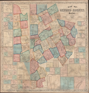
Map of Oxford County Maine.
$2,750.00
Acquire
- Digital Map Information
- Suitable for large format printing
- File Size: 500.18 MB
- File Type: ZIP / TIFF
- ICC color profile embedded
- Delivered instantly via download link
A superb example of H. F. Walling's 1858 wall map of Oxford County Maine. Composed of much of Maine's western border, the map embraces parts of the beautiful Rangeley Lakes Region, including Mooselookmeguntic Lake and the adjacent Richardson Lakes. (more details)