
Imprimerie J. Brinkmann (sold)

Imprimerie J. Brinkmann (1857 - 1940; 1946 - 1953) was a publishing house in Mulhouse, France. We have been unable to trace the founder. The publishing house was very active during World War I, publishing posters and announcements for the town of Mulhouse. After World War I, Brinkmann published a few unit histories for French infantry battalions. According to records in the Bibliothèque nationale de France, the Imprimerie Brinkmann did not publish during World War II and the German occupation of France. However, we have encountered a German World War II route map of the French campaign that ends in Mulhouse that bears the imprint 'J. Brinkmann - Mülhausen'. We have been unable to trace its source, but believe it to have been printed in a unit history published by Brinkmann for a German unit.
Rare German Unit Route Map issued during WWII.
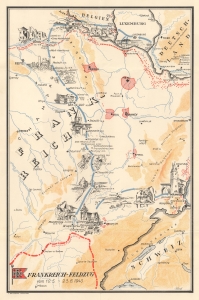
Frankreich-Feldzug vom 10.5 - 23.6.1940.
sold
- Digital Map Information
- Suitable for large format printing
- File Size: 9.15 MB
- File Type: ZIP / TIFF
- ICC color profile embedded
- Delivered instantly via download link
An extremely rare find, this is a c. 1941 German World War II route map of France illustrating a German unit's movements during the 1940 Battle of France. German World War II route maps are much less prominent than comparable maps made for American and British units. Here, dates when the unit entered French cities and villages in June and July 1940 are noted, creating a narrative of the unit's movements. (more details)