
Köke, F. (sold)

F. Köke (fl. c. 1855 – 1900), not to be confused with the economist Jens F. Köke, was a Vienna-based lithographer who produced maps and prints in several languages that circulated throughout the Austro-Hungarian Empire. No additional information is available about this individual(s).
Croatia, as part of the Austro-Hungarian Empire.
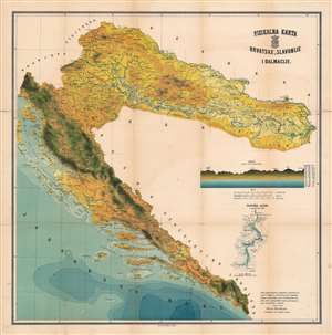
Fisikalna Karta Hrvatske, Slavonije, e Dalmacije / [Physical Map of Croatia, Slavonia, and Dalmatia].
sold
- Digital Map Information
- Suitable for large format printing
- File Size: 77.29 MB
- File Type: ZIP / TIFF
- ICC color profile embedded
- Delivered instantly via download link
This is a very rare c. 1900 map by Karlo Herdliczka and F. Köke of Croatia, or, at that time, the Kingdom of Croatia-Slavonia and the Kingdom of Dalmatia, both of which were subordinate to the Austro-Hungarian Empire. A physical map, it highlights topography and other elements of physical geography, especially waterways. (more details)